Zack
Forum Replies Created
-
AuthorReplies
-
Zack
ParticipantI have heard of folks riding the North Central Trail from the end of the Baltimore Light Rail to Indian Rock Campground near York, PA. They took MARC/Amtrak and Baltimore Light Rail to the trailhead and then returned the next day. I have ridden the North Central as a day trip and I wish it had trailside campsites, it was very remote and quiet in most places.
May 18, 2021 at 10:59 pm in reply to: legal basis of "Use Ped Signal" signs in Alexandria? public outreach? #1114317ParticipantHi Peter, I start riding on LPI for years and no one ever honked at me for that. I have not heard of any issues on Nextdoor related to this.
Try it out and see what you think!
Participant@DCAKen 210530 wrote:
Zack, are you working with the MWAA to put signage in at the airport directing people how to get to the bikeshare station?
Yes, we are working with them on it.
ParticipantHi Yule, unfortunately, we experienced a multi-year procurement delay thanks to our state DOT and that is why National Airport and several other stations were delayed for as long as they were.
While we would have loved to install the station closer to the terminal, as you noted, we cannot just bulldoze our way through, especially on land which is not owned by the County. Also, there is not an intuitive way to bike from the Mt Vernon Trail to the terminal anywhere else on the property.
Over the years, we try to move stations closer to the Metro entrances like we have done at East Falls Church Metro. We have two more on the calendar for installation in the next few weeks, one at Clarendon Metro and one at Rossyln Metro.
Regarding Arlington National Cemetery, we have identified a station location and hope to have more news on that site soon.
April 20, 2021 at 1:15 pm in reply to: Seeing non-CaBi dockless bikes using CaBi docks (seen at Roosevelt Island), Thoughts #1114183ParticipantHi Yule, I help manage bikeshare and scootershare for the County so thank you for sharing this photo. NPS does not allow dockless e-bike and e-scootershare parking on their property but I will check to see why these bikes fell through the cracks.
We are replacing Roosevelt Island’s equipment with a slightly larger station (17 docks) sometime in the next few months.
Participant@Judd 207956 wrote:
Has anyone experienced a ghost train on Slater’s Lane before? I was headed to the MVT this morning and the railroad crossing lights lit up and the arms came down for about 2 minutes. No train came through. As far as I know this piece of track was to bring coal to the power plant and hasn’t been used since the power plant shut down.
[ATTACH=CONFIG]24106[/ATTACH]
Twice, I have seen CSX park its track inspection equipment down this track but stop short of Slaters Ln. I think they use it when the line is less busy but occasionally store equipment during the day.
Participant@Judd 203026 wrote:
If there was the possibility of one major trail improvement on the Mount Vernon Trail near the airport, what would you like to see? Below are items that are contained in various NPS reports.
1. Improve the junction of Mount Vernon Trail and Four Mile Run Trail. A traffic circle was proposed as a solution in the National Capital Paved Trails report and the Mount Vernon Trail Corridor Safety study.
2. Straightening, widening and repaving of the trail from Four Mile Run northward. The Trail Safety study identified the curves and pavement conditions at the south end of the airport has a contributor to a number of crashes.
3. Improved crossing of the ramp from the airport to the Parkway (it’s that one where trail users have a stop sign, but cars often yield, but sometimes they don’t)
4. Gravelly Point bypass trail. There’s a concept to create a trail on the west side of Gravelly Point to allow through traffic to avoid the large amount of plane watchers and picnickers.
5. Something else?For number 3, I would like that ramp closed completely. It is not safe for people driving since there is no merge zone and the north exit is safer and faster for people driving. It was closed during trail improvements and the airport still functioned.
Participant@Starduster 201988 wrote:
When I went by on my #sizzlingsummercentury Saturday, it was removed/claimed…
Glad to hear it, thanks for posting it!
July 16, 2020 at 2:51 am in reply to: Four new CaBi stations to be installed in the City of Alexandria this summer #1106195Participant@chris_s 201868 wrote:
Probably better light for the station’s Solar Panel on the north side also.
For some developer-funded stations, the bikeshare station site is identified in their site plan. The conditions are spelled in out in a paragraph in the dsup. Beauregard & Berkeley, and Eisenhower & Ike both had sites already picked out in the site plan and in Eisenhower & Ike’s case, a concrete pad was partially built. Mt Vernon Trail & S Washington did not have a location identified in the site plan (it was generally funded by the 1199 S Washington St developer) so it could go across the street. As noted, solar access as well as access for the rebalancing van are other considerations for site selection too.
ParticipantI think someone I know commutes that way. I private messaged you his email.
ParticipantThis is the law regarding police officers and exemptions from traffic rules. Unless they had their sirens activated too (the law uses “and”), they were in violation.
https://law.lis.virginia.gov/vacode/title46.2/chapter8/section46.2-920/Participant@ursus 186955 wrote:
And that pothole has gotten bigger since October when you wrote this.
Yeah, I noticed that too. They had some illegal construction last May 21 that left the hole, they dug it with their equipment, and have not bothered to fix it properly. They probably need to rip out the whole stretch to repave it as it is not really designed for vehicles.
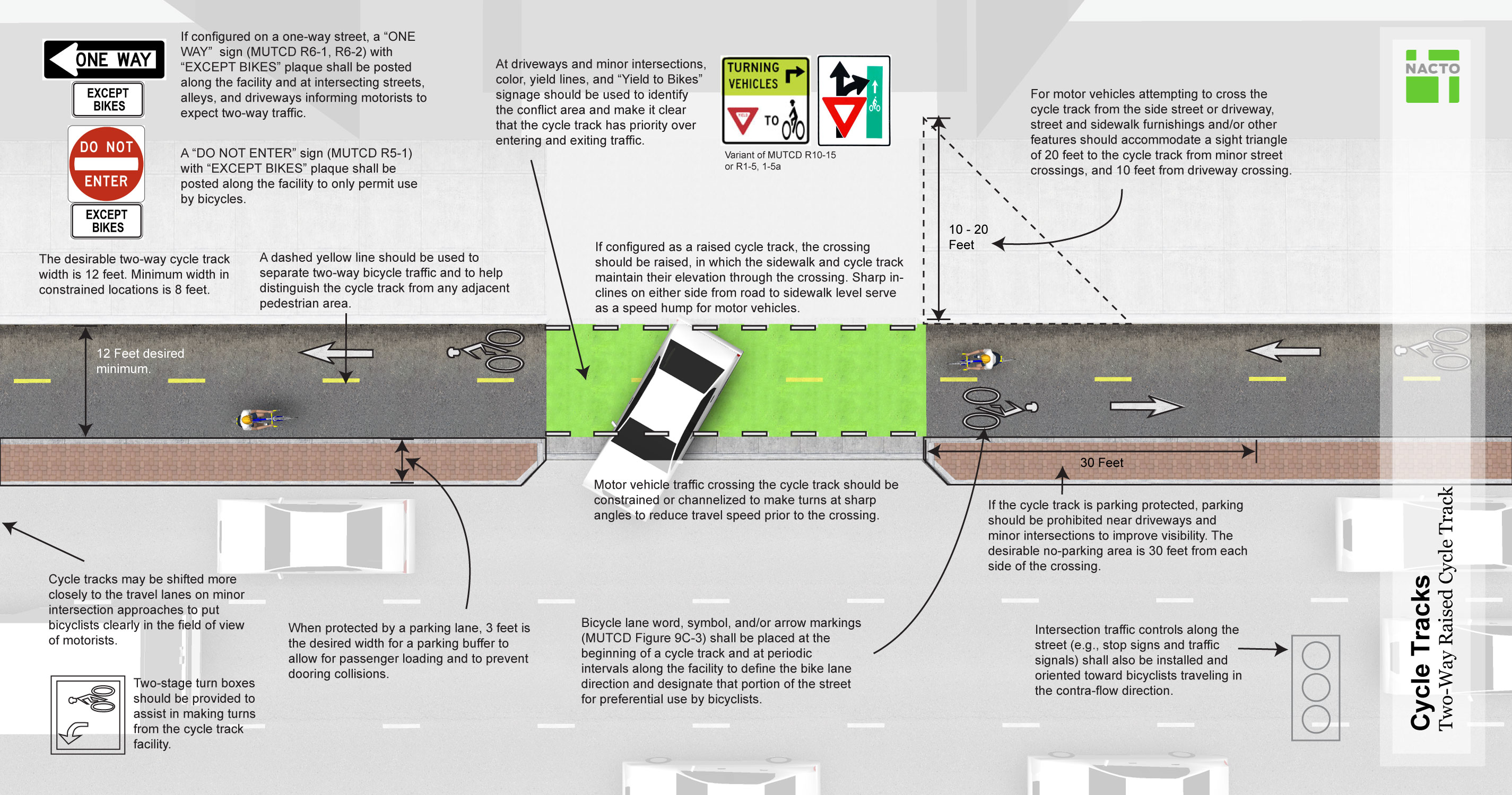
ParticipantLooking at the NACTO guidance, it does not appear that the Wharf cycletrack is compliant. The conflict zones should be green and while parking may be officially set back 30′ from the driveway crossings, illegal parking often occurs, so some kind of barrier is necessary.
[ATTACH=CONFIG]18467[/ATTACH]
[ATTACH=CONFIG]18468[/ATTACH]
 Participant
@JanaeBixby 181818 wrote:
Anyone notice the new “slow” and “stop” lettering accompanied by a white solid line (like that on the road where a car gets to a 4-way intersection) AT EVERY INTERSECTION along the bike route infront of the wharf?
Am I the only one who thinks that including these lettered-signals on the bike path puts the onus on the cyclist to prevent accidents where cars pull into and outof the wharf rather than requiring cars to yield when cyclists/pedestrians have the walk signal or where there is no walk signal/light? If a car hits you they can claim you had a stop, and they did not. Oh, and for each of those intersections where a car is coming out between building exiting the wharf, there is no solid large white line telling them where they need to stop before proceeding to cross the pedestrian and bike paths.
Seems a little unfair to the bikers. Makes me want to use Maine Ave. just to avoid having to stop at each intersection. Who am I kidding….. I’M NOT STOPPING (unless I have the red light)!
Seems like they are making it less and less conventient to use the designated bike path by the wharf each week. They also need to repaint the “cyclist” or “bike” icon on the ground to signal to pedestrians the intent of the path. That seems much more noticble than the small signs posted on poles. There used to be pictures of bikes on the ground if I remember correctly but they have since washed away.
Who do we contact about these things??!??!!!??
The public outreach person for the Wharf is Elinor Bacon, ebacon@erbacondevelopment.com. Have they fixed the pothole caused by illegal construction crew at the Wharf yet?
I saw that lettering too, I have never seen any guidance suggesting this. In fact, newer guidance does not suggest trail users “stop” as a precaution, those trail stop signs were meant as a warning.
I don’t know why they do not have marked crosswalks and white stop bars although that would not stop most people anyways. They have dedicated police officers for the Wharf, I wish they would do some block the box enforcement.
Participant@Emm 181625 wrote:
This morning while crossing E. Basin to get over to Maine Ave I had a good encounter with a DC Circulator driver. I signaled to turn right while biking up to the crosswalk. At this point the bus driver began slowing, and then got into the middle of both lanes and stopped at the crosswalk. The driver not only noticed my signal in advance of me getting to the crosswalk and reacted to it by stopping, he also was kind enough to know that seeing around him was difficult, so he blocked traffic until I crossed. This might be the best encounter with a bus I’ve ever had.
To be honest at that intersection I find DC Ciculator buses are sometimes the ONLY drivers who stop for me. They’re not perfect, but at least 2/3rds of them are good which is significantly better than other drivers and area bus systems…
Yeah, I have noticed the same thing, they are pretty good at that! Meanwhile, WMATA …
-
AuthorReplies