n18
Forum Replies Created
-
AuthorPosts
-
n18
ParticipantFrom today’s update, VA governor said “We hope to enter phase 1 next Friday, the 15th of May”, but he also said that it will be based on seeing declining numbers over a two week period. We are still at 500 to 700 new cases per day:
https://www.vdh.virginia.gov/coronavirus/
ParticipantVA governor extended business shutdown until May 14 but said he expects to begin rolling back restrictions after that. Expect phase 1 of reopening to start Friday May 15th. News conferences are made on Mondays, Wednesdays, and Fridays only.
https://www.washingtonpost.com/dc-md-va/2020/05/04/coronavirus-dc-maryland-virginia-live-updates/
ParticipantHere are public records that show maps with property boundary, and the owner of the property, just in case you want to see if a trail/path is on private or public land:
Arlington County
City of Alexandria
Fairfax CountyYou need to zoom in real close to see property boundary, and have a lot of patience. Click on a property to view details. Alexandria maps show a big box when click on something, to see details about a property, click on the dropdown that says “Tax map”, and select “Parcel ID”.
Participant@Steve O 200513 wrote:
It’s just a sign? What’s behind it?
The sign, shown here at the center of this StreetView(it’s too small to see), is posted as you enter Hargrove CT. I don’t know why someone posting a no trespassing sign on what seems to be a public road, but public records shows that the houses there are part of a home owner association, perhaps a “gated” community. It’s off road to say the least, and I don’t think that overgrown vegetation were trimmed recently.
ParticipantI just tried to see if the path I suggested is passable, but it appears that it’s not. On the East side there is a no trespassing sign, and it appears that the west side is inaccessible. The East side access is probably for VDOT/Utility companies, and I saw in places heavy vegetation that would block anyone from coming through. Here is an alternative path I tried, but there is one killer hill when going west.
I have used the “side” path on the North side of Lee HWY. It’s slow, but manageable.
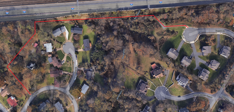
ParticipantFrom Google maps, it seems that there is a secret path connecting the neighborhood to the west of Cedar Lane to Nutely, from Hargrove CT to Mears ST, but I could be wrong. Here is the area in question, and here is a SteetView showing that one entrance is paved. It could be for the houses that are there, so it may not be accessible.
Here is the path I am talking about(in RED):
 ParticipantParticipant
Reader digest version: “On the basis of these results[of the simulation] the scientist advises that for walking[,] the distance of people moving in the same direction in 1 line should be at least 4–5 meter[12 to 15 Feet], for running and slow biking it should be 10 meters[30 Feet/10 Yards] and for hard biking at least 20 meters[60 Feet/20 Yards]. Also, when passing someone it is advised to already be in different lane at a considerable distance e.g. 20 meters for biking.”
ParticipantVA governor “threatened” today of closing parks and trails because of reports of abusers who don’t maintain physical distance. He said they will review what happens over the weekend to see if people gather in crowds, or don’t leave enough distance.
In other news, a time traveler said to me today that next Monday the governor closed all parks and trails in VA, siting crowded conditions despite the stay-at-home order.
What can you do to change it: deliberately go over the grass next to every walker/runner even if you have 6′ clearance(assuming you can), so they become more aware and distance themselves from each other.
ParticipantSome parks have basketball courts, even soccer fields, so closing parking lots discourages large gathering. All parks indoor facilities have been previously closed one week+ ago. I know there are areas where that doesn’t make any sense.
Also, from VA stay-at-home executive order(PDF), there is an exception to “Engaging in outdoor activity, including exercise, provided individuals comply with social distancing requirements”, so it’s allowed. The purpose of closing parking lots is discouragement, not prohibition.
Sunday/Monday the W&OD in Vienna was busy with walkers and cyclists, almost to the same level in this time of the year.
March 27, 2020 at 5:02 pm in reply to: Covid-caused question: can you replace batteries in blinkies? #1105529ParticipantDollar Tree sells CR2032 batteries. 2 for $1, but I see newer packaging to 1 for $1, but it seems they reverted to 2 for $1. They also sell 4Pack Alkaline batteries(AA and AAA) for $1.
March 25, 2020 at 3:03 pm in reply to: Big Fairfax Loop:WO&D from Airport toHerndon,Cross-Country to Occoquan/Mt.Vernon/airp #1105491ParticipantHere is another alternative on the west side. You just use Fairfax Country Parkway Trail, which was repaved in the last year or two. It’s flat or downhill mostly.
March 25, 2020 at 2:52 pm in reply to: Big Fairfax Loop:WO&D from Airport toHerndon,Cross-Country to Occoquan/Mt.Vernon/airp #1105490Participant@Char Miller 199615 wrote:
That is what I was wondering — if the Cross Country Trail part was too rough for a road bike. I take it that it is too difficult to ride with a road bike. That is a shame.
It was too rough to ride with a hybrid with front and seat suspension. Some example: every 10 feet there is a 90 degree turn to a steep or a rocky 10 feet, for horses to jump to, or hikers, and the list go on. There is a CCT marker to tell you where the trail is, but there are too many paths cleared by people to their houses and they look in a better shape than the trail, so I followed them and ended up going in circles. Here is an example short video:
https://www.youtube.com/watch?v=Dd2vM37NNdo&t=120
He is going downhill mostly, but imagine going the other way.
-
AuthorPosts