Cedar Lane Bridge closure?
Our Community › Forums › Where to ride? › Cedar Lane Bridge closure?
- This topic has 15 replies, 9 voices, and was last updated 4 years, 6 months ago by
huskerdont.
-
AuthorPosts
-
April 27, 2020 at 2:27 pm #1105715
 Steve OParticipant
Unfortunately, the two nearest crossings are either Gallows or Nutley.
Anyone with a MTB and a sense of adventure want to see if it’s possible to go under here?
[ATTACH=CONFIG]21473[/ATTACH]
April 27, 2020 at 2:43 pm #1105646Tania
ParticipantWell, crap. That’s on my pandemic walking route although wider sidewalks (eventually) will be appreciated.
As far as the cycling detour, I wouldn’t bike on Dorr Ave or Merrilee Ave (Merrilee Dr is ok) – both roads are covered with broken glass due to the recycling-truck-whatever-it-is on the corner across from Mr Tire. (Trust me, I live here and walk those two roads almost daily)
I’d probably take Prosperity – low traffic especially now and it’s two lanes in each direction so you can take the whole lane.
The western side of the path along Gallows is busy. The eastern side is narrow and less traveled. But it’s also made even more narrow by construction. Gallows is also two lanes but still has a lot of traffic and the speed limit is a joke. Do-able but maybe hustle.
April 27, 2020 at 3:37 pm #1105765scoot
ParticipantGallows is the obvious alternative to replace most trips currently using Cedar. But if your origin and/or destination are already a bit west of the Cedar bridge (e.g. riding from Villa Lee Park to Whole Foods), you might choose the western route. If so, consider crossing at Vaden. It’s not much further, and it avoids the worst aspects of the Nutley crossing (freeway ramps and poor sidewalk).
April 27, 2020 at 4:55 pm #1105774bikesnick
ParticipantApril 27, 2020 at 7:59 pm #1105775 bentbike33Participant
@bikesnick 200394 wrote:
The bridge over 66 on Vaden is being replaced. It was closed in October 2019 for 10 months.
And the official Vaden Rd ped/bike detour is the Vienna Metro station pedestrian bridge. Be sure to walk your bike.
") April 28, 2020 at 12:21 am #1105758
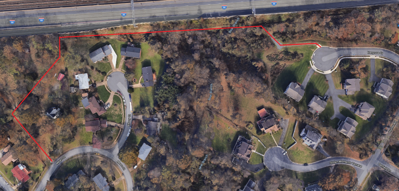
April 28, 2020 at 12:21 am #1105758n18
ParticipantFrom Google maps, it seems that there is a secret path connecting the neighborhood to the west of Cedar Lane to Nutely, from Hargrove CT to Mears ST, but I could be wrong. Here is the area in question, and here is a SteetView showing that one entrance is paved. It could be for the houses that are there, so it may not be accessible.
Here is the path I am talking about(in RED):
 April 29, 2020 at 2:09 pm #1105780
ts986
ParticipantLoving all these suggestions- I will have to experiment this weekend and see what seems like the safest.
May 2, 2020 at 7:43 pm #1105794ParticipantI just tried to see if the path I suggested is passable, but it appears that it’s not. On the East side there is a no trespassing sign, and it appears that the west side is inaccessible. The East side access is probably for VDOT/Utility companies, and I saw in places heavy vegetation that would block anyone from coming through. Here is an alternative path I tried, but there is one killer hill when going west.
I have used the “side” path on the North side of Lee HWY. It’s slow, but manageable.
May 3, 2020 at 4:34 am #1105801Steve OParticipant@n18 200500 wrote:
I just tried to see if the path I suggested is passable, but it appears that it’s not. On the East side there is a no trespassing sign,
It’s just a sign? What’s behind it?
May 3, 2020 at 2:01 pm #1105806Participant@Steve O 200513 wrote:
It’s just a sign? What’s behind it?
The sign, shown here at the center of this StreetView(it’s too small to see), is posted as you enter Hargrove CT. I don’t know why someone posting a no trespassing sign on what seems to be a public road, but public records shows that the houses there are part of a home owner association, perhaps a “gated” community. It’s off road to say the least, and I don’t think that overgrown vegetation were trimmed recently.
May 3, 2020 at 3:15 pm #1105807ParticipantHere are public records that show maps with property boundary, and the owner of the property, just in case you want to see if a trail/path is on private or public land:
Arlington County
City of Alexandria
Fairfax CountyYou need to zoom in real close to see property boundary, and have a lot of patience. Click on a property to view details. Alexandria maps show a big box when click on something, to see details about a property, click on the dropdown that says “Tax map”, and select “Parcel ID”.
May 7, 2020 at 9:01 pm #1105802ltierstein
ParticipantVaden is currently also closed for construction (5/7/20). Coming from the west I got across by walking my bike through the metro concourse.
December 21, 2020 at 7:57 pm #1107235ParticipantCedar Lane Bridge to open in two days(December 23, 2020):
http://outside.transform66.org/about_the_project/project_sections/cedar_lane.asp
It would have a shared-use path on the east side(17.5′) and a sidewalk on the west side(6.5′).
December 22, 2020 at 6:06 pm #1107262bentbike33Participant@n18 203143 wrote:
Cedar Lane Bridge to open in two days(December 23, 2020):
http://outside.transform66.org/about_the_project/project_sections/cedar_lane.asp
It would have a shared-use path on the east side(17.5′) and a sidewalk on the west side(6.5′).
Sigh. I will miss the flashing red light where Cottage crosses Cedar. That light won’t change for a bike and the east-bound pedestrian beg button is hard to reach.
The old Cedar Road was very narrow on either side of the bridge with no sidewalks north of I-66. What does the shared-use path connect to? Or does it just dump you back onto Cedar at each end?
December 28, 2020 at 1:31 pm #1107391huskerdont
Participant@bentbike33 203173 wrote:
Sigh. I will miss the flashing red light where Cottage crosses Cedar. That light won’t change for a bike and the east-bound pedestrian beg button is hard to reach.
I will miss that light as well–Fairfax has way too many lights that won’t change for a cyclist.
I will also miss bombing down Cedar from Gallows/Electric with the reduced traffic that made it feel not as harried.
Not sure if anyone remembers this, but back when they rebuilt the bridge over Scott’s Run, Georgetown Pike was closed to thru traffic for a while, and you could walk or ride on parts of it in bliss. Cedar was not quite that free, but some days, I’d ride from Electric to Cottage and encounter just a few cars.
-
AuthorPosts
- You must be logged in to reply to this topic.