chris_s
Forum Replies Created
-
AuthorPosts
-
 chris_sParticipant
Protected Bike Lanes being striped on N Veitch St today connecting Courthouse to Mom’s Organic Market / Custis Trail.
https://twitter.com/ArlingtonDES/status/1047131241009561601
chris_sParticipant@TwoWheelsDC 181300 wrote:
Just signed up! Looks like I’ll have to yank the battery from my Radwagon, so I guess we’ll find out how good of a non-e cargo bike it is…
This reminds me – I live about a mile from the ride start.
If anyone wants to leave stuff securely locked up at my house, you’re welcome to. Like if folks want to e-bike from their house to mine and then leave their battery securely at my house for instance. Let me know.
chris_sParticipant@LhasaCM 181307 wrote:
Question that probably falls under the “more trouble than it’s worth”: does the data coming from DC specifically delineate cases like G or I Streets NE where there’s a contraflow bike lane with a sharrow in the main travel lane? Right now, they show just as “bike lane” on the map, similar to how the printed map is.
Actually it does. DC is the only jurisdiction that is good about doing this. If someone has a suggested for a intuitive way to show it, I have the information to do so.
I also know in Arlington “bike lane” vs “buffered bike lane” but I’m not currently showing that distinction either.
chris_sParticipant@infinitebuffalo 181302 wrote:
Looks like some DC stuff is missing, too. At a glance, new sharrows on Kennedy St NW, bike lanes on Grant & Sherman Circles, new lanes near DC United stadium…
To some extent there’s just always going to be a lag. It’s not anybody’s priority to update their GIS the moment new bike infrastructure gets striped. I added Arlington’s Quincy Street lanes myself and noticed the Wilson Blvd extension isn’t in there yet. Mostly I’m looking for some obvious massive problem like “all of Fairfax County’s bike lanes are missing”
") chris_sParticipant
chris_sParticipantUgh. I have also reached out to Fairfax County who appears to have stopped providing bike lane info in their bike routes GIS layer.
chris_sParticipant@Judd 181290 wrote:
Do you have details on the hearing? I’m interested in attending and contacting my electeds beforehand.
You can speak in-person at the meeting by showing up and filling out a speaker slip, first-come, first-served. You must submit your speaker slip before the item is heard. Don’t be late. You can direct advance comments to both countyboard@arlingtonva.us (your electeds) and also to mobility@arlingtonva.us (staff).
Here is the staff report, which states the draft policy.
chris_sParticipantTwo things:
1) The main dcbikemap.com has been updated with working turn-by-turn directions.
2) I’ve pulled fresh cuts of data from the jurisdictions for a new version of dcbikemap. Anybody willing to scroll around and do some spot checking? I’ve got an e-mail in to Alexandria because their data is wildly out of date.Draft new version: http://dcbikemap.com/2.html
chris_sParticipantThe policy was pulled from the consent agenda and will receive a public hearing on Tuesday at 6:30pm.
chris_sParticipantArlington’s Shared Mobility Pilot (for dockless bikes & scooters) is on the Board’s “consent agenda” (for non-controversial items) this Saturday. Pilot would last 9 months, would charge each provider $8000 per mode and would limit all providers to 200 vehicles per mode with the possibility of asking for increases in 50 vehicle increments as long as they can show each vehicles is being used at least 3 times per day, with a hard limit of 350 vehicles per mode.
For reference, Bird currently has 500+ scooters in Arlington and is seeing 4 to 5 trips per scooter per day.
chris_sParticipantThe most recent schedule I’ve seen:
NEPA Completion FY 2018-2019
Design FY 2019-2021
Notice to Proceed (Design-Build) FY 2020
Construction Completion FY 2022The other important news since the website was updated is “The addition of a grade-separated trail crossing under the I-395 Southbound on and off ramp”
September 5, 2018 at 3:27 pm in reply to: Four Mile Run (FMR) trail debris under W Glebe Road #1089347chris_sParticipantThere’s a sticky thread at the top of this forum with how to report issues on various trails.
Arlington Trails: trails@arlingtonva.us or 703-228-6524
chris_sParticipantI have this same rack and like it a lot.
chris_sParticipant@dbb 180547 wrote:
It wouldn’t seem logical that the Corps of Engineers or the Federal Highway Administration
(the agency that was posited as the construction agent for the roadway). would be charged with the responsibility for identifying the design criteria for the realigned Columbia Pike. That leaves VDOT or Arlington County, so there may be opportunities for additional engagement.My take: Arlington County is designing the street & streetscape. The Army is deciding how much right-of-way they get to work with.
Option A: Try to get Arlington to re-allocate the space given to them by the Army.
Option B: Try to get the Army to give Arlington more space so they can devote more to bike/ped without having to re-allocate.
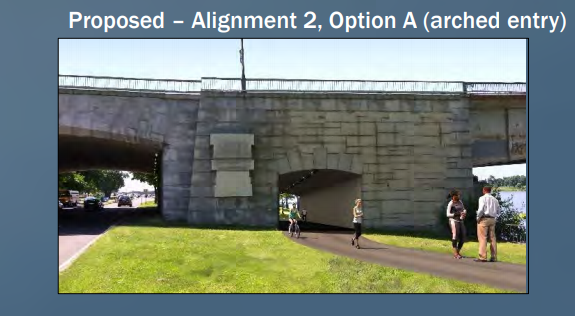
Option C: Bothchris_sParticipant@DCAKen 179983 wrote:
I was wondering if that section across from the Kennedy Center was being prepared for a trail detour for the construction of the overpass between the REACH and the Rock Creek trail
Could also be for the proposed trail realignment under TR bridge, but I don’t think that’s close enough to construction yet.
 chris_sParticipant
Yay media coverage!
The comments are…pretty predictably terrible and make it extremely obvious the extent to which most commenters read the article before commenting (not at all).
-
AuthorPosts