chris_s
Forum Replies Created
-
AuthorPosts
-
 chris_sParticipant
@dasgeh 190583 wrote:
Methinks a pie ride along the Pike is in order…
A ride from Acme Pies to Livin the Pie Life would be a great example for our decision makers of how terrible some areas still are for biking in Arlington.
Columbia Pike >> Glebe Rd. *blech*
chris_sParticipantFor what it’s worth, Arlnow’s editor tweeted that Arlington FD says they were NOT hit by a motor vehicle and that they’re in stable condition with non-life-threatening injuries.
https://twitter.com/howisthatlegal/status/1123279022497177601
chris_sParticipantLooks raised to me.
 chris_sParticipant
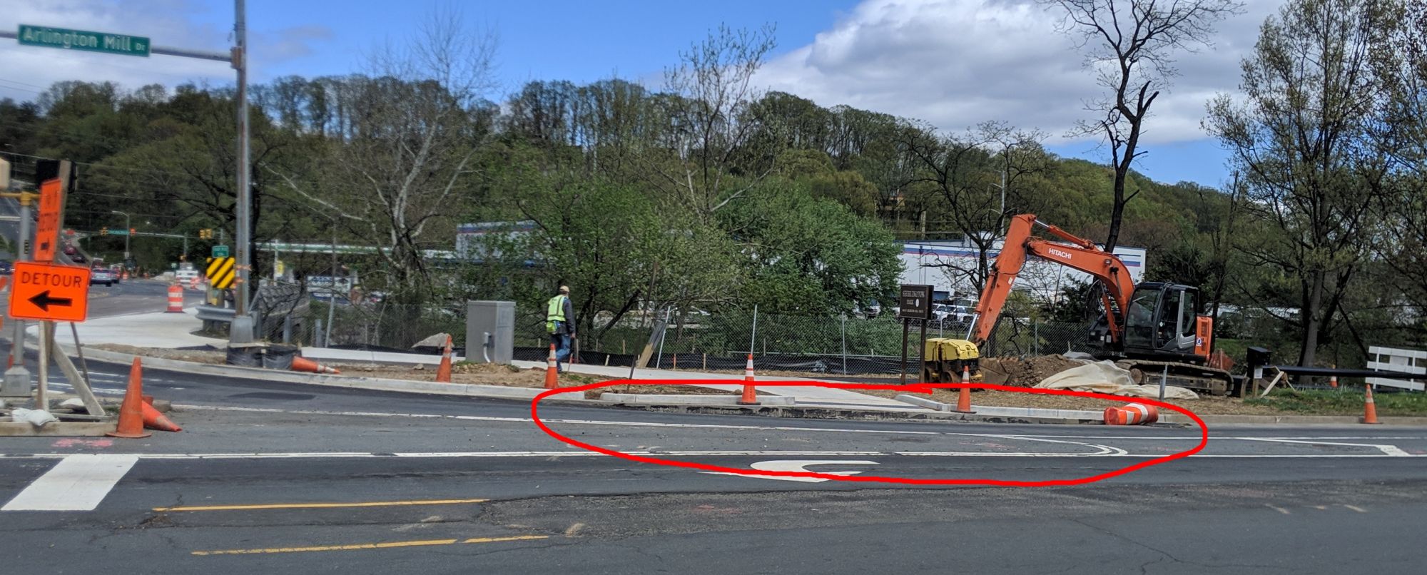
@zsionakides 189881 wrote:
I didn’t get photos, but it looks like the crossing of the slip lane on Arlington Mill Drive to the refuge area will be at road grade and not a raised crosswalk like shown in the project documents.
I expect that the raised crosswalk will be built the same time that the new refuge island is built (the next construction phase).
April 18, 2019 at 2:01 pm in reply to: County Board to Consider Bicycle Element Update for Approval on April 23 #1097782chris_sParticipant@Henry 189819 wrote:
All public comment goes first, for all agenda items, before the Board begins consideration of agenda items.
You sure? I am relatively certain that this is NOT the case here. In my experience this is only when covering consent agenda items that have been pulled for a hearing.
chris_sParticipant@Starduster 189802 wrote:
If we petition to make the “ANC” section of the Pike single lane with bike lane, will we be crossing swords with the Army’s plans, which seem to be locked in to “4 lanes the whole way”?
My read on the situation which I alluded to long ago in this thread:
The Army is deciding how much space to give the County.
The County is deciding how to allocate it.To get more space for bikes, we should be both lobbying the Army to give Arlington County more space and lobbying the County to better allocate that space.
chris_sParticipant@ltierstein 189743 wrote:
I’m sure this intersection has been the subject of previous threads, but this close call happened to me earlier this week.
I was bicycling toward Pentagon City on the wide sidewalk on the north side of Columbia Pike (this is being called/treated like a bike/ped path) just before where Washington Blvd crosses the pike. It was around 7 AM on a weekday. I got to the corner where the exit ramp from southbound Washington Blvd hits Columbia Pike. I checked the ramp, nothing was coming, I had the green light, so I started to cross. In the time it took me to get 2 feet into the road, a car coming down the ramp almost ran into me. I guess he looked to his left, didn’t see any oncoming traffic, and decided to make a right-turn-on-red. Luckily, I was going slowly (and riding defensively) and was able to stop before I hit the side of his car. AARGH. That intersection should be marked “No Turn on Red.”
You’re singing my song.
The existing interchange with Washington Blvd is extremely stressful and dangerous. Those riding in the road must not only contend with speeding traffic, but also with the right-turn only lane onto Washington Blvd at certain times of day. Those using the short piece of 10′ sidepath must contend with high speed traffic exiting onto Washington Blvd and cars turning right on red across the sidepath not expecting to have to look for cyclists.
A comprehensive safety review of the Washington Blvd / Columbia Pike interchange for cyclist and pedestrian safety in the next year. This interchange has been the site of numerous bicycle and pedestrian crashes since it was “improved” by VDOT several years ago. Timeline: within a year.
chris_sParticipant@dasgeh 189479 wrote:
If you really want to cut out hills, and don’t mind the extra distance or riding on 10th, you could do Rte 50 Trail (north/west side*) –> 10th –> Fairfax
* We really need better names for our trails.
I thought we’d all agreed to call the South/East trail the Fort Cass Trail.
chris_sParticipantThe online survey is up now if you would like to share your feedback.
Here are some thoughts from Sustainable Mobility for Arlington County, if you have other thoughts please share them so we can all crib ideas from each other.
1) 19th Street needs protected bike lanes in both directions from Ft Myer Drive to Lynn St. The Rosslyn Sector Plan calls for a new connection to the Mt Vernon Trail at the far east end of 19th Street. It is vital that a first-class bike facility exist on 19th Street to get people to and from that new trail connection.
2) Wilson Blvd needs protected bike lanes from Oak St to Arlington Ridge Road. This is the main East-West route through Rosslyn and an extremely stressful street to bike on. Additionally, significant pick-up and drop-off occurs which would lead to frequent conflicts for unprotected bike lanes.
3) If Ft Myer Drive and Lynn street’s protected bike lanes are, as proposed, at sidewalk level then the design must be bold and clear that this area is for bikes. It must be unmistakable and obvious using multiple visual and tactile indicators so as to avoid pedestrian conflicts.
4) Any planning for this area, including this study, must reinforce that either grade separation or re-routing I-66 traffic entirely, are the ultimate fix for the Intersection of Doom.
5) The ultimate design should feature “protected intersection” designs anywhere a protected bike lane intersects with another bicycle facility.
Project Page with background information
Meeting Display Boards
Ft Myer Drive concept renderings, including what the sidewalk-level 1-way PBL might look like
TAKE THIS SURVEYDeadline: April 3rd
chris_sParticipantTonight’s meeting will present a new concept plan, quite different from Concept #1 which was presented last October. Final drawings of Concept #2 aren’t out yet, but early drafts of this concept are significantly worse for biking than Concept #1 was. Things to watch out for:
1) Does it provide a low-stress bike route for the entirety of 19th Street? The Rosslyn Sector Plan calls for a new connection to the Mt Vernon Trail at the far east end of 19th Street. It is vital that a first-class bike facility exist on 19th Street moving forward to get people to and from that new trail connection. Concept #1 had a protected bike lane in both directions between Lynn and Ft Meyer with unprotected bike lanes east of Lynn.
2) Does it provide a low-stress bike route for the entirety of Wilson Blvd? Concept #1 dropped down to a SHARROW for eastbound Wilson Blvd between Nash and Lynn Street (with a great protected bike lane westbound). Does Concept #1 fix this problem? or make it worse?
3) Will the new designs resulted in a usable facility? Early drafts of Concept #2 switched from street-level, curb-protected bike lanes to sidewalk-level bike lanes. Many local residents have had bad experiences with sidewalk level cycling facilities along Maine Ave and elsewhere in DC. What are we gaining by moving to sidewalk-level facilities? How does the County intend to design them to prevent bike/pedestrian conflicts?chris_sParticipantWashington Blvd Trail Phase 2 is now appearing in Google Maps and being used for routing.
chris_sParticipant@dasgeh 187855 wrote:
Wait, I don’t seem to be able to attach PDFs. Thoughts?
If you e-mail them to me I can put them up on my server and post the links here.
January 23, 2019 at 2:51 am in reply to: Where are Freezing Saddles Participants Riding? Find out here. #1094589chris_sParticipant@Nadine 186301 wrote:
How do you make it work? Mine isn’t right – it doesn’t show anything on the Arlington loop and the w&od, and I’m not the only one who has hardly been off of those! Also it doesn’t move. Am I supposed to do something after the link pops up?
You’re just supposed to pick a team (or ALL) and pick a timeframe (day, week or all-time). It will then load the data (this might take a bit, especially for all teams). Once it loads it all, you can hit animate to watch it draw over time.
chris_sParticipant@Tania 183940 wrote:
“As Feuchtner mentioned, however, he hopes that the success of the split lanes will cause the changes to spread east and west of the City, making the improvements uniform rather than unique.”
Emphasis mine.
It’s a well-supported hope. NOVAParks has a feasibility study in-hand that covers Broad Street to George Mason Drive.
[ATTACH=CONFIG]18672[/ATTACH]
December 13, 2018 at 2:56 am in reply to: Arlnow.com article on the MTP Bike Element Update #1092203chris_sParticipant@DismalScientist 183742 wrote:
I certainly hope that the buffering of northbound bike lanes on McKinley from Wilson to the Custis only involve paint. Buffering with parked cars or flexiposts on a downhill when one can coast at the speed of traffic is dangerous.
Your hope has been realized.
-
AuthorPosts