Pentagon "desire path"
Our Community › Forums › General Discussion › Pentagon "desire path"
- This topic has 44 replies, 20 voices, and was last updated 1 year, 9 months ago by
 Judd.
Judd.
-
AuthorPosts
-
June 11, 2015 at 2:27 pm #1031881
Terpfan
Participant@Birdstrike 117830 wrote:
Yeah, the 25 mph speed limit is usually vigorously enforced on BCD. I can verify from experience…

It’s also a great way to skip traffic on the GWMP when you’re driving. I don’t think a lot of people realize how to use the road, which perhaps is for the best.
June 12, 2015 at 6:00 pm #1031978PotomacCyclist
ParticipantMajor crash on 395 at Boundary Channel this morning, involving three vehicles.
Elsewhere, two pedestrians were killed in car incidents in the greater DC area (DC and Gaithersburg) on Thursday.
June 12, 2015 at 8:32 pm #1032002Participant@PotomacCyclist 117947 wrote:
Major crash on 395 at Boundary Channel this morning, involving three vehicles.
Elsewhere, two pedestrians were killed in car incidents in the greater DC area (DC and Gaithersburg) on Thursday.
Yah, I was just mentioning the one on the ‘my evening commute’ thread. I literally rode through the intersection probably 10 minutes before it happened as it’s on my way home. Kind of surprising it’s a fatality since it’s a really speed limit there (25mph I think) and they have a speed camera nearby. But people on Calvert will run the red.
From what my coworker said, it was on Calvert right near Wisconsin. And one of those delivery-type trucks (he thought maybe Pea Pod) was there, which he presumed had hit the person.
Of course, as we all know, only cyclists are dangerous on DC roads….
June 12, 2015 at 9:01 pm #1032011ParticipantPlus a taxi flipped over and off the road near National Airport and an SUV driver rear-ended a tractor-trailer in Ballston. All this happened in the past 24-36 hours.
http://www.arlnow.com/2015/06/12/suv-runs-into-forklift-on-back-of-truck-in-ballston/
http://www.arlnow.com/2015/06/12/photos-taxi-overturns-at-reagan-national-airport/
June 23, 2015 at 11:48 pm #1032811ParticipantFrom the interchange meeting: MVT connection is a priority.
September 10, 2023 at 7:31 pm #1126839CaseyKane50
Participant@lordofthemark 57085 wrote:
So in a fit of exploration, I attempted to ride up the “desire path” or “scofflaw trail” that connects the end of the side trail from the MVT just south of the humpback bridge, to Boundary Channel Drive by the Pentagon parking lot.
It was a few inches wide (I was worried about poison ivy from the encroaching vegetation – maybe this is better in winter?) relatively steep grade in parts, and sloped off to the right. I ended up walking my bike for most of it, and only got back on for the “good” part, the ride on the grass along Boundary Channel.
A. Who uses this? Mountain bikers looking for a quick adventure?
B. What is the point of the stub end paved trail? Was there at one point a plan to extend that to Boundary Channel? Is there still?
LOTM, your more than 10 year wait is almost over. As of Friday, the new trail connecting to the Mount Vernon Trail at the Humpback Bridge is nearly ready for you to ride.

Path going towards Boundary Channel

Path blocked northbound towards the MVT
Same barricade, but looking towards Boundary Channel
Exit before the Humpback Bridge on the MVT towards Boundary Channel
September 10, 2023 at 10:39 pm #1126840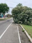 JustinWParticipant
While I’m sad that the thrill factor takes a hit with the development of the rest of this trail, it is better to see this and acknowledge the path’s use. It sucks when “good trails go bad” by stopping inexplicably. Any presumed increase in traffic on that trail (once it opens) may upset the homeless folks that often camp near the trail currently.
September 11, 2023 at 1:07 pm #1126841huskerdont
ParticipantI wonder if they’ll remove the abandoned moped that’s been there for months? And the downed tree.
This was one unnamed old man’s nature break spot, but I will prefer the completed trail for sure.
September 11, 2023 at 7:26 pm #1126846 lordofthemarkParticipant
@CaseyKane50 226142 wrote:
LOTM, your more than 10 year wait is almost over. As of Friday, the new trail connecting to the Mount Vernon Trail at the Humpback Bridge is nearly ready for you to ride.
Path going towards Boundary Channel
Path blocked northbound towards the MVT
Same barricade, but looking towards Boundary ChannelExit before the Humpback Bridge on the MVT towards Boundary Channel
And this, my friends, is why all the posts on here need to be preserved forever, at least in some kind of archive.
Thanks for the pictures Casey. As is my approach to the i66 trail, I have enough places I have yet to explore, for new infra I will wait till its officially open (usually).
I do pass the end of this regularly and quite eager to see it used.
September 11, 2023 at 7:57 pm #1126847JustinWParticipantWell, it is *open enough* that you can test it out……
") The new trail is extra wide, super smooth and really nice. It’ll be better when fences are down and dirt is replaced by grass, etc, but right now it is a lovely experience.September 12, 2023 at 5:07 pm #1126850lordofthemarkParticipant
The new trail is extra wide, super smooth and really nice. It’ll be better when fences are down and dirt is replaced by grass, etc, but right now it is a lovely experience.September 12, 2023 at 5:07 pm #1126850lordofthemarkParticipant@lordofthemark 117441 wrote:
Actually the lead agency is DDOT, since the Long Bridge is actually in DC, though I expect most public dollars will be federal (not sure if CSX will be pitching in anything) The street car connection is dead, I think – they could reserve a transit only lane for buses or they could add general travel lanes, or just save money and make it railroad plus bike/ped only.
While we are necromancing this thread, interesting that this last idea is what is actually to be implemented. But I was wrong about the lead agency, it’s the Virginia Passenger Rail Authority.
September 12, 2023 at 6:07 pm #1126852 arlcxriderParticipant
DDOT was the lead agency, but no longer. (They slow-walked it for nine years through the DEIS process.)
September 13, 2023 at 2:02 pm #1126856 chris_sParticipant
@lordofthemark 226154 wrote:
While we are necromancing this thread, interesting that this last idea is what is actually to be implemented. But I was wrong about the lead agency, it’s the Virginia Passenger Rail Authority.
In your defense, VPRA didn’t exist in 2015
September 14, 2023 at 3:45 am #1126859JuddParticipant@huskerdont 226144 wrote:
I wonder if they’ll remove the abandoned moped that’s been there for months? And the downed tree.
This was one unnamed old man’s nature break spot, but I will prefer the completed trail for sure.
Moped and tree are gone. NPS cleared out a massive amount of honeysuckle overgrowing the trail this summer. They even managed to back a chipper shredder down the trail and through the tunnel. The trail edge has some debris that needs to be removed and a couple of bumps and there’s some regrowth of the honeysuckle to cut again.
-
AuthorPosts
- You must be logged in to reply to this topic.