Four Mile Run Trail Closure Along South Glebe — Options
- This topic has 86 replies, 34 voices, and was last updated 8 years, 7 months ago by
.
-
Topic
-
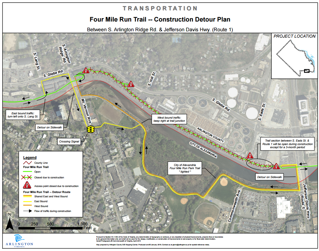
In December Dasgeh reported that Arlington County is planning to close the Four Mile Run Trail for up to a year (starting this summer, I believe) for stream restoration work. [ See this thread: http://bikearlingtonforum.com/showthread.php?9638-December-2015-ABAC-Meeting
The County staff is apparently planning to re-route cyclists across the Mt Vernon bridge to the Alexandria version of the Four Mile Run Trail as a detour. This news hit me very hard because that portion of the trail is a crucial part of my daily commute, and I am not comfortable tangling with S. Glebe Road traffic. So, I set about to see what the alternatives might be. Here is what I have discovered so far.
Aside from the bridge itself, the detour is not bad. The Alexandria trail is mostly newly paved (albeit with an abrupt return to very worn pavement near the end going east.) It is very well lit at night and is, if anything, more flat that then the Arlington segment behind the sewage plant. It IS longer as it is not a direct line.
Going east, once one reaches the end of the Alexandria trail, one can cross back over Four Mile Run on the sidewalk along US 1 (Jefferson Davis Highway). One will be going against auto traffic, but the sidewalk is wide so that should not be too much of a problem. For me, this will mean crossing S. Glebe again and then riding the S. Glebe Road sidewalk back up to S. Eads Street. For those wanting to continue east to the MVT, I am not sure if the county intends to close that part of the FMR trail as well… or what alternatives are suggested.
Westbound the routine would be the same. For me it will involve a ride east on the sidewalk along S. Glebe to US 1, crossing the bridge and then west on the Alexandria FMR trail.
There was some concern expressed about safety on the Alexandria side. I personally do not feel that unsafe there. It mostly passes through open space. There are some houses in one part in the distance but nothing is really that close to the trail. As stated, it is well lit and, if there is ample foot and cycle traffic, one should not worry too much. There may be more people hanging out in the summer, but I suspect there will be more cyclists and pedestrians too. In the winter the wide open spaces and ample lighting prevent anybody from popping out of nowhere.
The detour will take extra time. (I estimate up to 10 more minutes for me, because of the longer course, crossing the creek twice and waiting for the stoplight at S. Glebe and US 1.) Moreover, the Mt. Vernon Avenue bridge is not equipped for bicycles. The best option is probably to use the east side so as to avoid crossing Mt. Vernon Avenue. But the narrow sidewalk is similar to crossing Four Mile Run at the Shirlington Road bridge, only longer. I foresee heavy cycle and foot traffic going both ways on a narrow bit of concrete not suitable for passing. I may end up dismounting and walking over this gap.
If the county was serious about preserving the cycle commuting route a pedestrian/cyclist bridge parallel to the current automobile bridge would be ideal. It need not be fancy (like the one proposed downstream). A simple bridge like the ones that now cross the creek at Shirlington (near the new brewery) and at Barcoft Park would work. The land on both sides appears to already be public (owned respectively by the Arlington and Alexandria.) I suspect that there is no time to get through the wetlands permitting process or money to get this up in the appropriate timeframe. But it would eliminate a very serious situation at the current bridge.
More in a separate posting about other alternatives.


- You must be logged in to reply to this topic.