JimF22003
Forum Replies Created
-
AuthorPosts
-
JimF22003
ParticipantI actually have ridden to that point a couple of times, and I never can find where the trail picks up after that. What’s the secret?
Participant@hozn 92678 wrote:
The infamous Coxey Brown (http://www.strava.com/segments/667971) gains 991ft in 1.9 miles. Or Hamburg Road (http://www.strava.com/segments/620165) is 1037ft in 3.2 miles.
I found these routes the first time by googling a route named “OMGWTF”. Then I rode it.
OMGWTF!
ParticipantThere won’t BE a next time…
ParticipantThere’s some good steep stuff between the ridge on Mt Weather and the river. Really steep. You can make a decent loop of it. Something like this (either direction is good):
http://ridewithgps.com/routes/5647568
ParticipantI’ve ridden that road frequently, especially between Little Washington and Sperryville. Not horrible on a bike, but I wouldn’t want a car passing me at 93 MPH. Depending on which way you go, the roads are very rollery also. If you’re going fast enough you could probably launch yourself a la Steve McQueen in Bullitt.
Participant@bobco85 91807 wrote:
It’s strange thinking that less than a year ago (last October) I did my first century (mostly along the W&OD/Arlington Loop)
That was my “first time” as well
") Participant
Participant@bobco85 91788 wrote:
Last Saturday I was in Harrisonburg for the Shenandoah Valley Bicycle Festival.
Hey, me too. I did the 100. Pretty good day for a bike ride. That last slog in on Mountain Valley Road is something, innit? Good luck with the 100 next year.
July 29, 2014 at 2:17 pm in reply to: Noob to cycling, need advice, Annandale to Tysons Corner #1006882ParticipantHere’s the route I take from Annandale to Tysons, including the extension to Spring Hill Road I sometimes take when I go to the Honda dealership:
http://ridewithgps.com/routes/5466270
I see a few regulars on this route from time to time, notably Sir Dirt.
A couple of annotations, because some of this is only rideable on a bike, not on a car:
1) About 8.5, cut through the back of the office building instead of staying on Gallows where the bike lane peters out
2) About 8.8, go under the parking structure beside the Olive Garden to get to the frontage road along Rt 7.This is actually where I work, but sometimes I take the rest of the route to Spring Hill
3) 9.4 crossing Chain Bridge Road. Take the cross walk on the West side of International Drive onto Pinnacle. This is closed to cars, but is perfect for bikes, and keeps you off Int’l
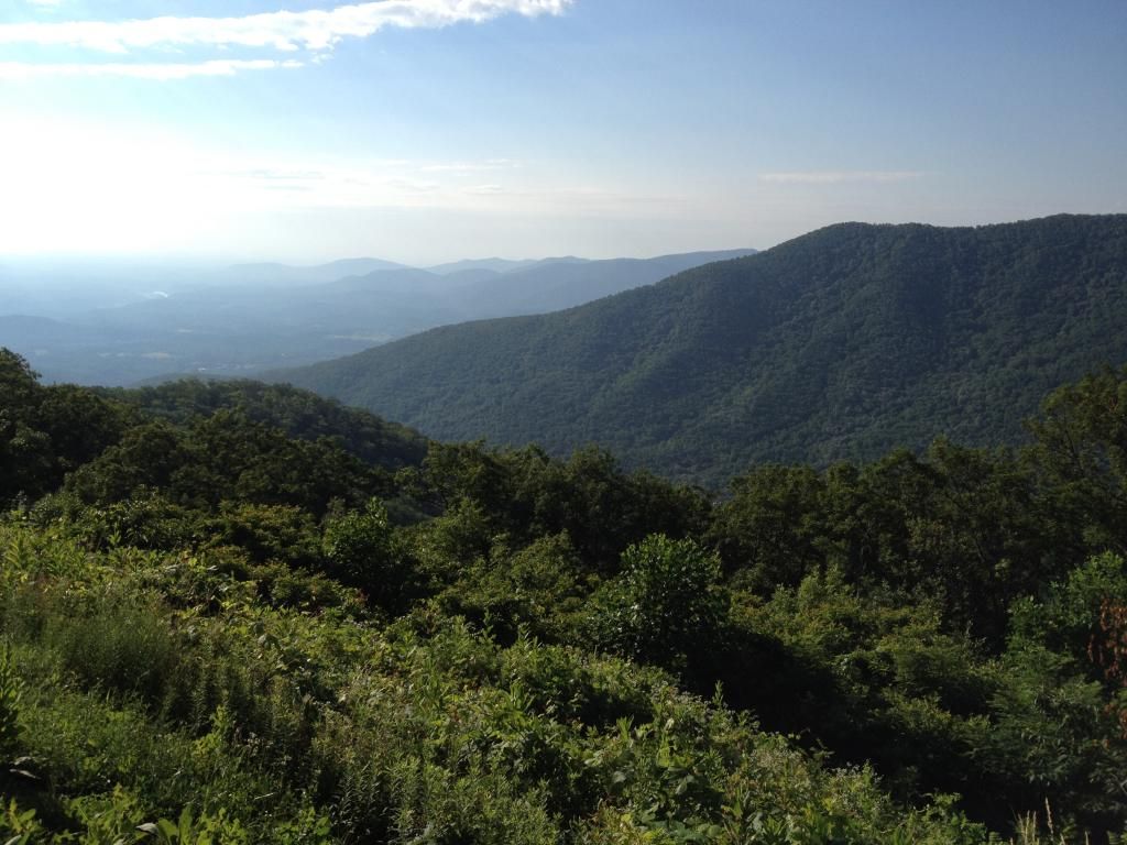
ParticipantSunday I picked up where I left off from Friday’s ride, from Peaks of Otter down south past Roanoke Mountain. These two pics are from a spot where the parkway runs right along the top of the “ridge” of the Blue Ridge. The first pic is looking West into the Shenandoah Valley. The second pic is looking East to the piedmont area between Lynchburg and Roanoke:

 Participant
The Blue Ridge Parkway is now practically in my backyard, from my new 2nd home in Lexington. Here’s the view from the Terrapin Mt Overlook on the Thunder Ridge climb:
 Participant
@bobco85 89352 wrote:
In addition to my mileage goal, during spring I came up with a new goal for the year: to do the 100 mile ride for the Shenandoah Valley Bicycle Festival. It takes place on July 26 and is very hilly. I have only done the 50 mile ride a few times, so this is going to be the hardest bike ride I’ve ever attempted, but I will do my best. Here’s hoping that my goals will be achieved!
I’ve done this one 3 or 4 times. Haven’t decided on this one yet. You should do fine, with your mileage and your previous experience. There’s a really nice long 1-2% downhill stretch that goes on for several miles into Fulks Run, that is my favorite part of that ride. Good luck!
Participant@sjclaeys 88485 wrote:
I’ll have some more pictures from this weekend’s ride near Wintergreen, but here is a start from Saturday’s ride up to the Blue Ridge Parkway. Here is that day’s route: http://ridewithgps.com/routes/5052829.
[/quote]
Oh man, we must have just missed each other. I came up the opposite way from Vesuvius on Saturday (and came up from the Wintergreen side on Sunday.) Small world!
Saturday: http://connect.garmin.com/modern/activity/520634558
Sunday: http://connect.garmin.com/modern/activity/521378574I’m too lazy to take pics though
 June 16, 2014 at 7:32 pm in reply to: W. Post article: Airlines change gears on passengers flying with bikes #1004205Participant
I have the large Thule hardshell case in excellent condition if you’re interested. Only used once. Send me a PM if you like.
Participant@ctankcycles 88293 wrote:
Thanks, it was a great time with perfect weather. We passed through Goshen near the end of the third day (http://app.strava.com/activities/145159748) and continued west on Maury River Rd which becomes Mountain Valley Rd (route 42/39). The next day (http://app.strava.com/activities/145159746) we continued west on Mountain Valley and then made a right on McClung Rd (629) which turns into Deerfield Rd. We were only on Deerfield for 6 miles before picking up Indian Draft (678). Indian Draft follows the Bullpasture River much of the way and was a great road with lots of nice rollers and almost no traffic. There’s also almost no water between Millboro and McDowell, about a 30 mile stretch. We ended up stopping into a Virginia State Fish Hatchery and the guy there was super nice and let us fill our bottles. In the future I’d take a small water filter for situations like this. Eventually Indian Draft turns into Bullpasture River Rd, which took us into McDowell where we hit the Stonewall Grocery (Stonewall Jackson is a local hero for winning a battle there), and then headed east on Highland Turnpike and eventually Hanky Mountain Hwy. This was probably one of the more challenging sections with two very steep, switchbacked climbs and a lot more traffic (including trucks) than we had for most of the trip.
Sounds wonderful. I’m just getting to know the roads up in that area, so that helps a bunch. You might be interested in the Mountain Mama century ride that starts in Monterey, over in that general area.
ParticipantSounds like you had a great time! What was your route out of Goshen? Last weekend I rode in that area, going up Marble Valley and Deerfield Valley through Deerfield, up to west of Staunton. It was some incredible, peaceful, secluded scenery. I’m in the process of buying a house in Lexington. Next time you come through you can camp in my back yard
-
AuthorPosts


