chris_s
Forum Replies Created
-
AuthorPosts
-
March 15, 2018 at 2:01 pm in reply to: TAKE ACTION: Arlington Capital Improvement Plan Survey #1085497
 chris_sParticipant
Last chance! Survey closes tomorrow!
chris_sParticipant@elbows 175225 wrote:
I’ve lived as regular cyclist within a block of Walter Reed (WR) for over 10 years and I fail to see what the big improvement is with this expense. What am I missing? You can already cross WR at the light. I cross WR on foot several nights a week after 9pm and driver stoppage in those crosswalks is better than at most, in my opinion.
It’s part of trying to complete the 12 St Bike Boulevard to the point of it actually being useful. Not enough pedestrians and cyclists currently cross Walter Reed at 12th Street to “warrant” a signal there. There’s a light at 11th, but 11th Street east of Walter Reed is one-way. This project would paint a contraflow bike lane on that block of 11th St and upgrade the signal to support a cyclist being able to roll up in that contraflow lane and push a button to be able to get a green signal to cross Walter Reed. This essentially moves the Bike Blvd from 12 the 11th from Highland eastward. This works out ok because of the current difficulties the County has had extending the Blvd eastward given the poor grid connectivity over there. The County has had little luck getting Arlington Village to grant them an easement to continue the 12th St Bike Boulevard through their property between Cleveland and Barton or between Barton and Wayne. Instead the Blvd will likely (at least for now) be officially signed onto the alley behind Celtic House and a new alley that will be created behind Rappahanock when the revelopment project there goes through. Combine that with the new connection being built by the Wellington between Rolfe and Scott and we’re down to one piece still to go (in light blue on the map below) to actually provide a route that will get you to the proposed Hoffman Boston Connector that would go along the edge of the Country Club to get you under 395 without having to ride on the Pike or the Pike sidewalk.
[ATTACH=CONFIG]17177[/ATTACH]
@elbows 175225 wrote:
Personally, I think a better improvement would be to quit requiring pedestrian actuation at the traffic lights at Pike/WR and Pike/Barton which both see heavy pedestrian usage.
However, the County is updating its automatic pedestrian signal policy and once it has completed this process it will re-evaluate the automatic signals at specific intersections.
I agree! Transportation Commission has been pushing for the County to have an actual adopted signal policy and until it can do a public process to create one, to improve its internal policy.
February 16, 2018 at 3:46 pm in reply to: Any discussion of a bike lane on George Mason around Leesburg Pike? #1084121chris_sParticipantFairfax County Bike Plan appears to show bike lanes south of 7, sharrows north of 7.
chris_sParticipantThe deadline to take the online survey and make comments is FRIDAY. Get to it!
chris_sParticipant@Kathrynestockinger 173727 wrote:
Can you bike through Fort Myer?
I am new to commuting via bike to work and I am looking for a good alternative to riding on Columbia Pike. I searched on google and came across a form allowing bike commuters to access Fort Myer. I filled out the form and had my husband, who works for the DoD, sign it as my sponsor. However, when I took the form in today, they told me that it was old and that bikers no longer have access to base unless they have a reason to be on base. Does anyone have experience with this?
I’ve confirmed through my contacts at Ft Myer that cyclists with a sponsor are still being issued AIE passes, even if it’s just to pass through the fort. She said they had even issued one today. She would like assistance figuring out where the disconnect is and who is giving out incorrect information. Were you told this at the “gate” or the “visitors center”?
Feel free to follow up via forum direct message if you’d prefer.
February 1, 2018 at 4:54 pm in reply to: Arlington County Parks & Recreation assessing pavement conditions during February #1083391chris_sParticipant@Erin Potter 173975 wrote:
“Arlington County Department of Parks and Recreation plans to evaluate the condition of asphalt pavement on off-street trails during the month of February 2018.
Yay!!!
Only 10 years after the policy was adopted in the Bicycle Element of the Master Transportation Plan:
Incorporate County trail repaving/repair into a regular maintenance cycle similar to that used for County streets including periodic pavement quality assessments.chris_sParticipant@huskerdont 173950 wrote:
…I do want to mention My Local Homebrew Shop as an alternative to our Amazonion and big-box overlords.
Also worth checking out The Brew Shop on Wilson Blvd between Rosslyn & Courthouse.
chris_sParticipantDid you miss the meeting? FEAR NOT.
Weigh in with this County Online Survey on the project. In addition to answering the guided questions, I encourage you to make ample use of the free-form comments box at the end to hammer home some of the points raised below, or earlier in the thread, or whatever else speaks to you.
– As Arlington’s first 2-way PBL of any significant size, residents will judge all future PBLs on this one. It should not be overly narrow. Please expand to 12′ wherever possible. Automotive turn lanes do not need to be 11′ wide.
– Allowing right turns across a two-way facility is potentially very dangerous. Please do not do this, or at least provide a leading bicycle interval with a dedicated bicycle signal to give cyclists a chance to get out where they are visible to turning cars.
– Please provide dedicated queuing spaces for cyclists waiting for the appropriate signal to enter or exit the protected bike lane.chris_sParticipantTo spark discussion, here is a monster dump of my (and some other folks) questions and comments:
Comment headings are ordered from West to East along the corridor and each heading includes comments about the intersection + any section of street between that intersection and the next intersection to the east.
Overall
a. Where driveways, parking garage entrances, etc cross the PBL should have signage and green paint, speed humps.
b. PBL should be extended to 12’ wide rather than 10’ wherever possible. Per NACTO, this is the desired with for two-way cycle tracks. This is a better use of space than unnecessarily wide 11’ turn lanes for automobiles. As Arlington’s first 2-way PBL, residents will judge all future PBLs on this one. It should not be overly narrow.
c. Bike Signals at all intersections? Placement?
d. Right turns on red prohibited across the PBL?
e. Leading Bicycle Intervals?
f. What are the median Plantings where it is just shown as green? Grass? Shrubs? Other?Joyce Street
a. This design fails to fill the ½ block gap on Joyce Street to connect the Northbound Joyce Street Bike Lane to Army Navy Drive.
b. Does not appear to fully solve the problem of transitioning bikes from the Joyce Street “Shared Use Paths” under 395 to the Joyce Street Bike Lanes and the new PBL. Perhaps better to have a fully depressed curb on NE and NW corner of Army Navy / Joyce?
c. Yay Floating Bus Stop. Will it have a shelter? How wide is median?
d. How are westbound cyclists expected to transition from the two-way PBL to the more conventional one-way pair of bike lanes west of Joyce? How can we make it clear and comfortable?Mall Entrance
a. Does Traffic Analysis truly warrant double left turn lanes here?
b. Will permissive lefts from those left turn lanes be allowed? Or only on green arrow?
c. Curb Cut for Mall parking garage entrance and exit is extremely wide. Can existing median between entrance lanes and exit lanes be extended to provide a true pedestrian refuge? Can entrance lanes be only 2 lanes wide when crossing the sidewalk & the PBL and the widen out to 4 immediately after?
d. Entrance/Exit consolidation east of the main mall entrance is a big improvement.
e. Need median to prevent left turnsHayes Street
a. Create “right turn lane” for eastbound PBL riders so they can turn right on Red at Hayes without getting stuck behind cyclists waiting at the light to proceed straight. There appears to be sufficient space in the median buffer of the PBL to make this happen.
b. How do cyclists coming up the Hayes St bike lanes turn left into the PBL? Is there additional design work we can do to facilitate this movement?
c. Concerned that trees planted in median buffer so close to intersection will obscure right-turning drivers’ view of cyclists. Hope that’s just “concept design art” and not actual proposed tree placement.
d. With the Hayes bus stop being removed, where is the next closest bus stop?Fern Street
a. Fern is supposed to be the main bicycle entrance to the Pentagon, according to their Master Plan. How can we better accommodate the bicycle turning movements from the PBL onto Fern heading toward the Pentagon?
i. Can a “right turn lane” be created for Westbound PBL riders to wait in so that they aren’t blocking Westbound riders who are proceeding straight while waiting for the signal to change?
ii. Can a “2 stage left turn box” be created for Eastbound PBL riders to wait when they are attempting to turn left toward the Pentagon?Eads
a. How much curb-to-curb space on Eads are these new curb lines leaving? Can it accommodate an extension of the Eads Street PBLs to Army Navy or would we need to move the curbs again later to accommodate that? What is the current plan for Eads between 12th and Army Navy Drive after PenPlace redevelopment?
b. Will the north end of Eads at least be re-striped to at least get the northbound bike lane all the way to Army Navy? It currently disappears 1/3 of a block back.
c. Create “right turn lane” for eastbound PBL riders so they can turn right on Red at Eads without getting stuck behind cyclists waiting at the light to proceed straight. There appears to be sufficient space in the median buffer of the PBL to make this happen.
d. Is parking being moved from the South Side to the North Side east of Eads due to sight lines?
e. Can median be continued between PBL and Parking to prevent encroachment into the bike lanes? How wide is the buffer currently shown between the parking lane and the PBL?
f. Do the south-side parking spaces between in front of the DoubleTree block sight lines for drivers trying to see oncoming bike and car traffic?
g. Need to put median back in across from doubletree alley to prevent left turns. This movement is prevented by a median currently.12th St S
a. Ban left onto Army Navy from Eastbound 12th
b. Army Navy Drive Crosswalk at 12th Street should be a raised crossing.chris_sParticipant@dasgeh 172782 wrote:
On the East end, why have a median? Won’t that make the street feel wider and encourage speeding? And, if we didn’t have the median and shifted the lanes over, wouldn’t we get more usable space on the edges of the right of way
I believe the research leans more the other way – that medians are better at making the lane feel narrow, causing drivers to slow down and be more cautious than just narrowing with paint.
Also we need that median to prevent left turns into and out of these driveways – that’s a very dangerous movement across a 2-way PBL.chris_sParticipanthttps://www.arlnow.com/2018/01/23/police-charge-three-teenagers-in-four-mile-run-trail-stabbing/
Police have charged three Alexandria, VA juveniles for their involvement in a stabbing on the Four Mile Run Trail on Monday evening. The suspects, ages 16 and 17, were each charged with Aggravated Malicious Wounding, Conspiracy to Commit Aggravated Malicious Wounding and Gang Participation.
At approximately 4:50 p.m. on January 22, police were dispatched to the 3400 block of S. Glebe Road for the report of a stabbing. Arriving officers located one male victim suffering from multiple stab wounds and immediately began performing life saving measures. The victim was transported by Alexandria Fire Medics to George Washington University Hospital with serious but non-life threatening injuries.
The investigation determined that the male victim was walking on the trail when he was approached by the suspects. Following a verbal altercation, the suspects assaulted the victim before fleeing the area. Arriving officers established a perimeter and located three suspects matching the descriptions provided by witnesses.
The investigation into this incident is ongoing. Anyone with information about this investigation is asked to contact Detective Henretty of the Arlington County Police Department’s Gang Unit at 703-228-4110 or Mhenretty@arlingtonva.us. Information may also be provided anonymously through the Arlington County Crime Solvers hotline at 1-866-411-TIPS (8477).
chris_sParticipant@consularrider 172727 wrote:
To be fair, the Alcova Heights “stated” opposition is to the taking of private land via easement and or eminent domain which would be needed for a trail to connect sections of S Oakland St. From the map it does not appear that would be necessary to follow the GSA Option 1 along the NFATC boundry line.
“via private or federal property.”
They’re against all of the options, especially Option 1 because those 6th Street homeowners have co-opted federal property and built gardens and sheds and stuff beyond their own property line.
The neighbors turned out to their meeting. Bike & walk folks didn’t turn out to ours. This is likely a dead issue.
chris_sParticipant@Henry 172612 wrote:
Is there a proposal on the table, or is this just the start of the discussion? Also, did Alcova Heights take a formal position as a civic association?
I thought we were talking about 3rd St S >> Quincy @ 6th St S (Trail 2 in the below graphic) but it sounds like what’s being discussed is 3rd St S >> Oakland at 6th St S (Trail 1 in the blow graphic). Looking forward to learning more tonight.
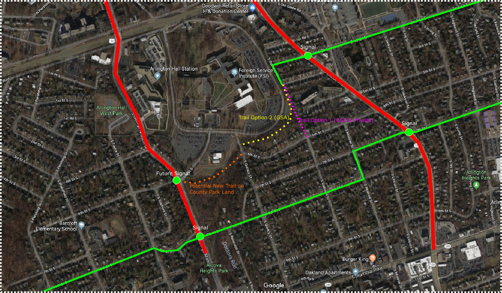
Alcova Heights Meeting report out (from the AHCA pres):
We had a very well attended (and long) meeting Thursday evening. We spent about 2 1/2 hours on the Foreign Affairs Training Center. County staff updated us on their plans to get GSA to extend their existing agreement allowing the West Parcel (the area on the other side of George Mason) to continue to be used as a park. Having a long term agreement will allow the County to invest in upgrading the facilities there. We also discussed GSA’s plans to move the security fence around the State child care center. Their proposed fence will cut through the sledding hill. We’ve known this for some time and we’ve repeatedly asked GSA not to cut off the sledding hilll – to no avail. We asked the County again Thursday night to help us save the hill.
Most of the discussion revolved around the easement that the County is pursuing so that it could build a trail at some point in time to connect 3rd Street with 6th Street at Oakland Street. After a lengthy question and answer session with County staff and a discussion period after County staff left, a motion was made that Alcova Heights oppose obtaining an easement that would allow a path to be built. The motion (below) passed with 31 in favor and 16 opposed. I will be drafting an email to send to the County Board and will share what I send.
MOTION: To express the views of the Alcova Heights Citizens’ Association that we are opposed to any property easements or eminent domain to establish a path or road connecting 3th and 6th Streets via private or federal property.
chris_sParticipantTonight!
-
AuthorPosts