Post your ride pics
Our Community › Forums › Pictures & Videos › Post your ride pics
- This topic has 3,838 replies, 162 voices, and was last updated 1 year, 7 months ago by
 Henry.
-
CreatorTopic
-
March 25, 2013 at 10:39 am #913045
dcv
ParticipantShare sights from your rides here
-
CreatorTopic
-
AuthorReplies
-
November 6, 2013 at 2:42 am #985319
bobco85
ParticipantI went up to New York City this past weekend to cheer on my sister who ran in the NY Marathon. On Sunday morning while my sister was making her way to the start in Staten Island (I was going to cheer her on when she got between the 17 and 18 mile mark in Manhattan), I took a few hours and rode on a CitiBike along the East River Greenway to Battery Park and then along the Hudson River Greenway. Weather was in the 40s (F), overcast, and windy.
[ATTACH=CONFIG]4012[/ATTACH]
Oh no, the totalitarian state has taken over with their oppressive blue bikes![ATTACH=CONFIG]4013[/ATTACH]
Pano of Williamsburg Bridge over the East River[ATTACH=CONFIG]4014[/ATTACH]
This is what happens when there are no flex post bollards…[ATTACH=CONFIG]4015[/ATTACH]
…and this is what happens when there are flex post bollards[ATTACH=CONFIG]4016[/ATTACH]
Manhattan BridgeNovember 6, 2013 at 2:50 am #985321Participant[ATTACH=CONFIG]4017[/ATTACH]
This section had a divided bikeway, one direction on either side of the pillars (note the jogger going against traffic)[ATTACH=CONFIG]4018[/ATTACH]
Pano of the Brooklyn Bridge with the Manhattan Bridge and Brooklyn in the distance[ATTACH=CONFIG]4019[/ATTACH]
The Hudson River Greenway (looking north at Freedom Tower) featured separated 2-way paths, the right for cyclists/rollerbladers and the left for pedestrians[ATTACH=CONFIG]4020[/ATTACH]
farther north on the Hudson River Greenway; bike stoplights being used, and you can see the separate path for pedestrians[ATTACH=CONFIG]4021[/ATTACH]
the mostly overcast sky helped make the fall colors really stand outNovember 6, 2013 at 3:47 am #985331mstone
ParticipantYou know the EPA is doing its job when people go for scenic rides along the East River
November 6, 2013 at 12:18 pm #985337November 6, 2013 at 2:51 pm #985353dasgeh
Participant@bobco85 68512 wrote:
I took a few hours and rode on a CitiBike along the East River Greenway to Battery Park and then along the Hudson River Greenway.
Thanks so much for posting these! I used to live in StuyTown, so I took that route a LOT. Great trip down memory lane…
November 9, 2013 at 9:11 pm #985614Rod Smith
ParticipantProteus Farm Team

In the Patuxent Research Reserve

Our fearless ride leader, known to you as Greenbelt
 November 10, 2013 at 7:33 pm #985630Participant
Hooked. Rookie mountain biker Mike on a bike he recently purchased used for $150. More recently he’s purchased (and anxiously waiting delivery of) a fat bike costing over 15 times that price!
 November 10, 2013 at 9:17 pm #985631
JimF22003
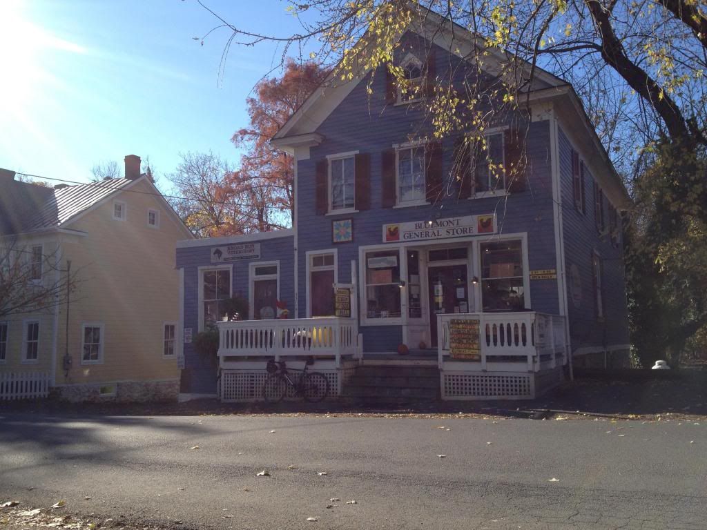
ParticipantFirst rest stop on a 100 mile ride on Saturday, from Leesburg, out Snickersville Pike, to the Shenandoah, out to Front Royal, and back via Rectortown and Purcellville. This is beautiful downtown Bluemont at the base of the ridge of the Blue Ridge Mountains:
 November 10, 2013 at 10:06 pm #985633
Jason B
Participant^^^^
Sounds like a great ride. If you can, post the strava. Although that general store has a wonderful charm and delicious little ham sandwiches, it usually means a hellish climb up Mt Weather.November 10, 2013 at 11:07 pm #985635ParticipantNot Strava, but here’s from Garmin Connect. Instead of taking the 601 route past Mt Weather I went down to the river and followed 606. It’s very pretty, but has some pretty steep stuff too:
http://connect.garmin.com/activity/402040085
November 11, 2013 at 1:32 am #985637ParticipantLoyalty Road, Waterford, VA
 November 11, 2013 at 2:06 am #985638
rpiretti
ParticipantNovember 11, 2013 at 11:08 am #985644Dirt
Participant
Yeah….. Sheridan was a jerk, to put it mildly, but his statue is quite comfy.November 12, 2013 at 3:26 am #985703ParticipantI took Veterans’ Day off from work and decided to follow as much of the DC diamond as I could in a clockwise direction, stopping by many of the still-intact boundary stones on the way. The total distance I traveled was 58.7 miles, and that includes getting to/from the diamond. For the most part, mapping the route was fun, using Western, Eastern, and Southern Avenues for much of the MD border and part of King Street for the VA border. That said, the section where I ended up going on Kenilworth Road was not desirable at all, even if there was a sign on the 3 lane “let’s go as fast as possible” road that said “Bicycles may use full lane.”
I was surprised there are so many stones intact considering that I’ve passed by a few of them many, many times without even knowing their significance.
(EDIT: Forgot to add this line) Here’s the ride on Strava: http://www.strava.com/activities/94573339
The site I used for reference in creating a good route to hit as many boundary stones as possible (and for more information on their history): http://www.boundarystones.org
I would recommend the full ride to anyone who 1) likes scavenger hunts, 2) is comfortable riding with traffic on 35-40 mph speed limits for a few sections of road, and 3) has the stamina for the many hills you will climb on this trip. You could also take smaller sections of this as well.
[ATTACH=CONFIG]4046[/ATTACH]
Map showing my route and boundary stones visited[ATTACH=CONFIG]4047[/ATTACH]
Taking a break at the hard-to-find (seriously it’s 100 feet off in the woods from the corner of Southern and Eastern Avenues) East Cornerstone[ATTACH=CONFIG]4048[/ATTACH]
The 4 cornerstones arranged as a compass (note: the South cornerstone is covered, so for the pic I had to reach my arm past a grate to get a clear shot)[ATTACH=CONFIG]4049[/ATTACH]
VA boundary stones (left to right, top row: SW-8, SW-9, SW-1, bottom row: SW-5, SW-6, SW-7)[ATTACH=CONFIG]4050[/ATTACH]
MD boundary stones (left to right, top row: NW-6, NW-9, NE-2, NE-3, bottom row: NE-4, SE-1, SE-2, SE-7)November 12, 2013 at 1:10 pm #985709Participant@hozn 68262 wrote:
Yeah, I agree with dcv. I ride it on my cross bike with 700×32 tires (tubeless helps avoid pinch flats). It certainly is faster / more care-free on my single speed 29er (especially some of the more technical new trails in Lake Fairfax), but there is nothing better than riding single track on the way to work — and the mtb would really make a slog of the other 14 miles.
Ok, buddy and I did a portion of the CCT out near Great falls for the first time, about 25 miles total. It was a great run, but I would have to say, the mountain bike made it a blast. Although I can see it being faster on a cross, picking your lines, the mtb allowed me to say, “f’ the lines” and just crank with little thought. My mtb is an old classic beater, and it beat on some trails. I am definitely doing that again.
Thanks for posting that ride and advice! -
AuthorReplies
 this morning’s view.


- You must be logged in to reply to this topic.