Data and techie stuff thread for BAFS 2016
Our Community › Forums › Freezing Saddles Winter Riding Competition › Data and techie stuff thread for BAFS 2016
- This topic has 133 replies, 34 voices, and was last updated 9 years, 3 months ago by
hozn.
-
AuthorPosts
-
February 3, 2016 at 8:07 pm #1047079
 chris_sParticipant
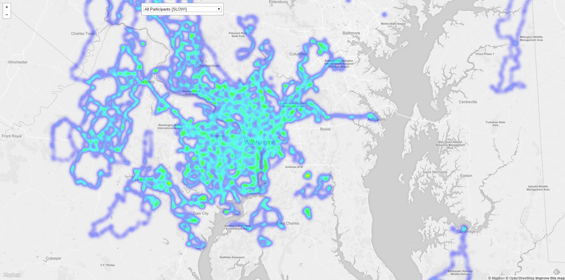
Sneak Preview for those who bother to follow this thread:
It’s a slow proof of concept right now, and it will only be updated sporadically…but it’s pretty cool.
An “all participants” heatmap is going to have to wait for performance improvements.
February 3, 2016 at 8:09 pm #1047081February 3, 2016 at 9:33 pm #1047089elwbikes
ParticipantWow, Chris S! That is spectacular!!! It will make my “around the world” and “around the country” pointless prize winners much easier to spot!!! Thank you!!!
February 3, 2016 at 10:04 pm #1047091chris_sParticipantAn alternate heatmap view built on different tech that I’m playing around with: http://dcbikemap.com/heat/leaflet.html
February 4, 2016 at 2:20 pm #1047117vvill
Participant@chris_s 134199 wrote:
An alternate heatmap view built on different tech that I’m playing around with: http://dcbikemap.com/heat/leaflet.html
This one’s even better!
Great to see my team has ridden around so much of the DC area, not to mention in Pittsburgh, MA, FL, OR, CA. Really interesting to see all the team distributions and how some of the local teams have stayed west of the river compared to others.
February 4, 2016 at 2:40 pm #1047119 jrenautParticipant
I’m planning to go out the W&OD today because my team’s heatmap shows me that none of us have yet.
February 4, 2016 at 4:34 pm #1047142chris_sParticipant@vvill 134226 wrote:
This one’s even better!
Leaflet seems faster to me and I like how I can make the basemap fade more into the background to really highlight the actual heat map.
Does anyone else have an opinion on the relative merits of the two versions?
February 4, 2016 at 4:51 pm #1047146Subby
ParticipantBoth are great but the second one looks cooler.
February 4, 2016 at 5:28 pm #1047154chris_sParticipantWow.
We get around.
Stay tuned.
February 4, 2016 at 5:35 pm #1047157Vicegrip
ParticipantVery cool stuff. Thank you for the time spent.
February 11, 2016 at 2:55 am #1047623 JuddParticipant
Hey hozn,
What Strava segment is used to determine whether a Hains Point lap is completed on the leaderboards? Team 13 and Team 3 are battling it out for most HP laps. We think it might be the Gate to Gate segment, but we’re not sure. There’s lots of places that one can start and finish a lap at HP and we want to make sure that we’re not losing laps by starting or finishing in the wrong place.
Thans for the help!
February 11, 2016 at 1:58 pm #1047606Participant@Judd 134769 wrote:
Hey hozn,
What Strava segment is used to determine whether a Hains Point lap is completed on the leaderboards? Team 13 and Team 3 are battling it out for most HP laps. We think it might be the Gate to Gate segment, but we’re not sure. There’s lots of places that one can start and finish a lap at HP and we want to make sure that we’re not losing laps by starting or finishing in the wrong place.
Thans for the help!
It is gate to gate.
https://www.strava.com/segments/1081507February 11, 2016 at 3:14 pm #1047619jwetzel
Participant@vvill 134822 wrote:
It is gate to gate.
https://www.strava.com/segments/1081507[ATTACH=CONFIG]10936[/ATTACH]
February 11, 2016 at 5:09 pm #1047757hozn
Participant@vvill 134822 wrote:
It is gate to gate.
https://www.strava.com/segments/1081507Yes — thanks vvill for running that to ground; I had forgotten which one it was, but it’s obviously in the code/html.
February 11, 2016 at 9:12 pm #1047746JuddParticipantI vote to disqualify all laps from Team 3 that are only gate to gate and not full laps. The honorable Team 13 never skips out on completing the lap by riding down Buckeye.
-
AuthorPosts
- You must be logged in to reply to this topic.