Support the Trail Bridge over Lee Highway
Our Community › Forums › General Discussion › Support the Trail Bridge over Lee Highway
- This topic has 88 replies, 29 voices, and was last updated 6 years, 8 months ago by
 Judd.
Judd.
-
AuthorPosts
-
January 25, 2017 at 8:06 pm #1064710
bobco85
ParticipantI found what appears to be the letter that was sent to the County Board from the Arlington – East Falls Church Civic Association. It was posted in a comment on ArlNow https://www.arlnow.com/2017/01/25/county-board-to-vote-on-backing-i-66-widening-projects-goals/ . The letter is long, but reading it should give a better idea of what the civic association’s goals are for their community if not at least some food for thought.
Subject: VDOT Proposed Overhead Bike & Pedestrian Bridge – Lee Highway
The Arlington – East Falls Church Civic Association and citizens petition VDOT, Arlington County, Northern Virginia Regional Parks and the City of Falls Church to immediately pause the proposed VDOT overhead bridge crossing over Lee Highway near I-66. This VDOT project, if not paused, will create problems for holistic future pedestrian and cyclist transit development in the area, as well as create negative impacts on the surrounding neighborhood in a way that a more thoughtful design would not. Although we need a trail crossing, we need a plan that considers more than solely the VDOT controlled right of way. Pause this project so the neighborhood and the surrounding areas can fully consider the problems we are trying to address (both present and future).
1. Improved Safety Measures & Improved Bicycle and Pedestrian Network in the Vicinity-The present state of the W&OD trail is dangerous. Cyclists face serious hazards as they make their way to the W&OD trail navigating through busy neighborhood blocks already inundated with cut through traffic (cars and pedestrians) from Metro users, a high volume of motor vehicles cutting through the neighborhood to reach I-66, school buses trying to load and unload and neighborhood residents simply trying to come and go from their homes.
2. Need for Missing Segment of W&OD Trail- As serious cyclists commute on the trail, they are essentially dumped out for a five block span into a neighborhood that intersects considerable traffic, both vehicular and metro commuter pedestrians. Any plan to provide an overhead bridge should restore the missing segment of the trail as the missing segment causes friction and dangerous near misses regularly.

3. Neighborhood Development – Arlington- East Falls Church Area Plan – The proposed bridge would place a major and permanent obstacle in the middle of a neighborhood space that is central to smart future neighborhood development (including a West Entrance to the EFC Metro and possible overhead I-66 development). Properly planned, this development will unify the two halves of a neighborhood bisected by I-66. This is the heart of the vision expressed throughout the East Falls Church Area Plan.4. Impediment to Future West Entrance to EFC Metro – Arlington has the opportunity to create a true multimodal improvement by creating a West Entrance to the East Falls Church Metro. The VDOT proposed bridge would stand in the way of this opportunity to serve Arlington and Falls Church residents looking to use Metro and help get more cars off the road. The bridge’s Eastern abutment will present a nearly insurmountable challenge to the design of a Western entrance to the East Falls Church Metro.
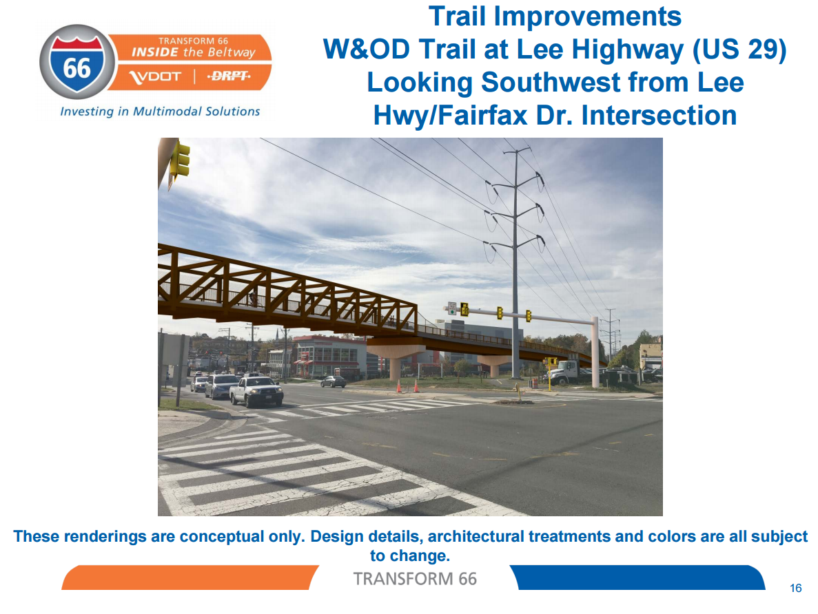
5. Visual Impact to the Area – This bridge, at nearly a fifth of a mile in length and approaching three stories in height presents a massive visual and functional barrier to the sights and activity of East Falls Church area, particularly the pedestrian oriented design of the highway at this location.
What is the vision for EFC in Arlington? – For the past two years we have endured the VDOT Spot 2 project near this location (which is still not complete) and are now faced with this proposed impending overhead structure as part of the I-66 Tolling/Widening Project. We do not need more structures along with the additional billboard signs to advertise dynamic tolling. This area should be planned for as the inviting Western entrance to Arlington County, not a “truck stop” feel where cars race through to access I-66. How does this bridge impact the discussion around a true connective solution for our community? Why is there no conversation about the crumbling sidewalk on the narrow bridge that is unsafe to walk on to cross over I-66 to get children safely to and from Tuckahoe Elementary School? How does this impact the large scale renovation of the near by Benjamin Banneker Park that has trail improvements as part of its project plan?
Sample of Alternate Suggestions Include:
1. A trail alignment that proceeds from the west along Four Mile Run
behind the Fire House, under Lee Highway (using existing box culvert) and behind the West Lee condominium and live work units where it returns immediately to Westmoreland Street, whence as a bike lane or side path it follows Westmoreland to 19th Street to Van Buren Street to reconnect this the existing trail in Benjamin Banneker Park.2. Taking the W&OD across Fairfax Drive at the same intersection, going under the
Lee Highway overpass, and following the I-66 right of way across Sycamore St, across or under the eastbound I-66 onramp and reconnecting with the W&OD trail at the landmark known as Brandymore Castle.We ask that you take a step back from this bridge and evaluate with the many groups involved to look at sound and BETTER solutions than this band-aid bridge that does not position ARLINGTON for success. Please note, the neighborhood only learned about this bridge in October. I would ask that VDOT provide you with data specific to Arlington residents on their thoughts about the inside the beltway project for your review when after their public comment period on January 30th.
January 25, 2017 at 11:08 pm #1064722KLizotte
Participant@thucydides 153519 wrote:
Note that the Arlington-East Falls Church neighborhood association (or least its president) has come out against the project in a letter to the council. It’s cloaked in “let’s slow down and study this language” but the clear intent is to kill it. She cites a hodge-podge of “let’s see if something sticks” reasons. Many if not most are pure non-sequitur, e.g., there are flaws in other parts of the trail so let’s not fix this if we can’t fix it all. A real doozy complaint is that a bridge, “presents a massive visual and functional barrier to the sights and activity of East Falls Church area.”
So people complain when government tries to fix a problem and they complain when government does nothing. Which is it people?!!!!???? Please make up your mind because I’m getting dizzy!
Even if they don’t like cyclists what about kids, the elderly and disabled trying to cross that intersection??
Massive visual barrier? Ummmm, it’s a ten lane intersection next to a major highway that bisects the area. It’s pretty hard to get uglier than that. We promise to put up a pretty bridge. Really. Trust me!
Between this and what is happening in the WH and the Hill at the moment my head is gonna explode.
Adding it to my list of outrage emails I have to send, I’ll send a note to the county this weekend.
January 26, 2017 at 12:51 am #1064728 lordofthemarkParticipant
hmmm. I suppose it would be better for all to have a solution that completely takes the W&OD off the neighborhoods streets there. Not sure if their alternatives are viable though. Anyone know about that culvert, is it really a feasible place to put in a trail? As for a big bridge/connection all the way to the castle, that sounds very expensive. Not sure how much the I66 project is actually making available for bike/ped improvements, and how many competing projects there are. Since this has apparently been on the County Master Plan for a while, I would imagine that the alternatives have been examined.
January 26, 2017 at 1:31 am #1064732 chris_sParticipant
@EasyRider 153537 wrote:
Chris, you wrote that the design is up in the air. It sounds like aesthetics matter to those who are opposed to it … as if they’ve got some image in their mind about what it will look like, or have seen one is the area that bothers them. Are there any preliminary sketches or existing models that they might be reacting to? (“a massive visual and functional barrier”)
Yeah, VDOT’s concept rendering is about as bulky as can be.
 January 26, 2017 at 2:00 am #1064734JuddParticipant
@chris_s 153569 wrote:
Yeah, VDOT’s concept rendering is about as bulky as can be.
I actually agree that it’s not a very attractive bridge.
Sent from my iPhone using Tapatalk
January 26, 2017 at 2:29 am #1064735DrP
Participant@Judd 153571 wrote:
I actually agree that it’s not a very attractive bridge.
Sent from my iPhone using Tapatalk
It is hideous. VDOT clearly only designs giant highway interchanges. I can understand why they are complaining if that is the option. They need something more like what is across route 7.
I think I know the culvert the letter mentions – 4MR (the stream) goes under Washington St about where that traffic light for the fire station is. There is no trail of any kind there. They would need to take land from other places (e.g., car repair, fire station, etc.) to get the re-routing I think the letter is implying – which would be continue 4MRT into Issac Crossman Park and then continue the trail until about where the bridge over the stream is near the fire station. That isn’t going to happen either. Too much land needs to be taken from others and I am sure there are folks who will complain about bicycles in the park – they are prohibited at present. Also, we do not need another under-road crossing next to 4MR that will flood in the rain – because then we will need to go to the road to cross and piss everyone off.
January 26, 2017 at 2:48 am #1064739JuddParticipantI took a look at Google Street View images of a couple of bike trail bridges that I’ve traveled.
West Orange Trail Bridge in Apopka, FL – I like the look of this bridge (except the concrete palm trees).
https://www.google.com/maps/place/Apopka,+FL/@28.67314,-81.5069873,3a,60y,270h,90t/data=!3m6!1e1!3m4!1sSk3oABIe8cPaIsAOD-ISrg!2e0!7i13312!8i6656!4m5!3m4!1s0x88e77739cc157c19:0xd71d0f8ffc80e888!8m2!3d28.6934076!4d-81.5322149!6m1!1e1Metro BikeLink bridge in Belleville, IL – I hate the color scheme of this bridge and the font used, but I like the concept of wording/signage.
https://www.google.com/maps/@38.5298305,-89.9841671,3a,75y,71.01t/data=!3m6!1e1!3m4!1sWtPhTYuEhi3nMulkHm9pDA!2e0!7i13312!8i6656!6m1!1e1January 26, 2017 at 2:58 am #1064744mstone
ParticipantIt’s not the bike users that decided to ban themselves from crossman park…
January 26, 2017 at 3:53 am #1064750JuddParticipantLet me be the first voice for abandoning the idea of a bridge and instead creating a tunnel. This is a video of a ride I did on the Seminole Wekiva Trail in Florida. The trail has two underpasses, both of which are at the intersection of major multi-lane highways.
January 26, 2017 at 4:23 am #1064751dkel
ParticipantI feel like I’ve heard this before:
1. A trail alignment that proceeds from the west along Four Mile Run behind the Fire House, under Lee Highway (using existing box culvert) and behind the West Lee condominium and live work units where it returns immediately to Westmoreland Street, whence as a bike lane or side path it follows Westmoreland to 19th Street to Van Buren Street to reconnect this the existing trail in Benjamin Banneker Park.
Did someone discuss this option—or something very similar—on the forum before? Steve O maybe? I like this much better than a bridge over the existing crossing, but would prefer an actual bridge to a proposed trail alignment lost in endless community/committee debate.
January 26, 2017 at 4:25 am #1064752ParticipantWhy does VDOT’s bridge have to be so long? I know they are trying to minimize the gradient but why? All I can think of is ADA requirements. There are steeper gradients along the trail due to hills. Perhaps because they have to build the bridge high enough so trucks can get through. Perhaps spirals could be used at both ends to get up to the top of the bridge. I agree that the bridge over Rte 7 is unobtrusive.
How about a tunnel instead?
January 26, 2017 at 1:30 pm #1064758huskerdont
ParticipantIt’s not lovely, but it’s no uglier than the Metro lines in Tyson’s. The W&OD bridge over 28 is kind of ugly too, but no uglier than 28 itself; this bridge is exactly as ugly as its surroundings. It really should be more like the one over Route 7 though.
Rerouting is just a bait and switch. Once the bridge was dead, the rerouting would be opposed by the same people, plus some others.
A tunnel would have to be well done or some folks (like me) would just stick to the at-grade crossings. Tunnels can be expensive too, which is the reason Metro at Tyson’s is above ground.
January 26, 2017 at 1:41 pm #1064759chris_sParticipant@KLizotte 153589 wrote:
Why does VDOT’s bridge have to be so long? I know they are trying to minimize the gradient but why? All I can think of is ADA requirements. There are steeper gradients along the trail due to hills. Perhaps because they have to build the bridge high enough so trucks can get through. Perhaps spirals could be used at both ends to get up to the top of the bridge. I agree that the bridge over Rte 7 is unobtrusive.
How about a tunnel instead?
I’ prefer a tunnel, but it’s a false choice. If they don’t build the bridge, they aren’t going to build a tunnel. They’re going to do nothing except dump more cars across the intersection and maybe study a tunnel in 5 years and maybe build it in 15 and if they do it’ll be Arlington money not State money.
January 26, 2017 at 1:43 pm #1064760chris_sParticipantAnd to be clear, the bridge hasn’t been designed. That’s a concept, but the bridge could look completely different.
January 26, 2017 at 1:51 pm #1064763Tim Kelley
ParticipantMaybe they can put in a tunnel at Lee Highway after they put in a tunnel under Lynn Street??
-
AuthorPosts
- You must be logged in to reply to this topic.