Southwest Waterfront redevelopment, Water St. to be closed
- This topic has 109 replies, 21 voices, and was last updated 9 years, 11 months ago by
.
-
Topic
-
The Wharf is a $2 billion multi-building redevelopment of the Southwest Waterfront. (Not a security officer aboard the USS Enterprise.) Groundbreaking is scheduled for March 19. Construction could continue for the next 4 years. The new development will include apartments, offices, condos, hotels, a movie theater, a jazz club, a piano bar, a country-western bar and a 6,000-seat concert hall. The developer also wants to add LED lighting to the nearby Case Bridge (I-395).
Of particular note for cyclists is the removal of much or all of Water Street. The new buildings will be constructed up to Maine Ave. (A cycle track is planned for Maine Ave. See the next post below.)
One of the JDLand pictures shows the Kastles team tennis stadium torn down. That was only built in 2011. I think the new development includes another Kastles stadium, but I haven’t looked at the plans recently. It shouldn’t take that long to build a new stadium. The old one wasn’t that large (maybe 1,000 capacity?) and it was made of scaffolding and bench seating for the most part. I hope they improve the drainage system. When it rained during a match last summer, the entire pedestrian area got flooded, even though it was only a typical summer rain shower.
I’m not sure of the exact construction schedule, but expect Water Street to be closed at some point in the near future.
According to the project website, there will be 1,750 bicycle parking spaces throughout the development:
http://www.thewharfdc.com/office/office_numbers.htm
======
According to the following blog, there will be a 10-ft. wide “bike lane” and a 15-ft. wide sidewalk along Maine Ave., separated by a row of street trees. Sounds more like a cycle track to me. If so, good.http://southwestquadrant.blogspot.com/p/southwest-waterfront-redevelopment.html
A wide Wharf Street will replace Water Street. A 20-ft. wide section will be reserved for seating. The middle 20 ft. will have limited vehicular travel and possibly a street car. The other 20 ft., closest to the shoreline, will be reserved for pedestrians.
======
June/July 2015
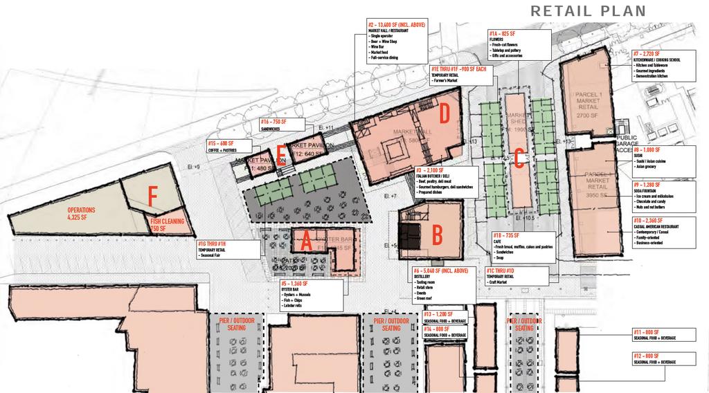
MAINE AVENUE FISH MARKET PLAN
Hoffman-Madison Waterfront, the developer of The Wharf, also holds a 99-year lease on the Maine Avenue Fish Market. They have essentially combined the market with The Wharf in their planning.
They have just revealed plans for an extensive renewal of the fish market. I’m not sure if I heard about this before. I thought they might skip over the fish market, but it makes sense to do some work there too. The parking lots and access lanes are in poor shape and the plot looks run-down and just plain ugly. It’s the first thing that visitors see when traveling from the Tidal Basin to the future Wharf.
In this video, the CEO of PN Hoffman (one of the partners in Hoffman-Madison Waterfront) says that they will add a rum distillery, a pavilion, outdoor seating and a large market hall with a beer/wine shop, a restaurant, and an Italian butcher. (I don’t know why they specify an Italian butcher, but that’s what the article says.) The fish market will be retained but spruced up a bit. The CEO says that they are working with the people who live aboard the boats in the nearby marina to address concerns that they may have.
The U.S. Commission of Fine Arts is looking at the proposal. They seem cautiously optimistic about the plans.
The article includes a slideshow of concept renderings, plus a site plan. The text of the plan document is too small to read clearly. You can open the image in a new tab to get a slightly larger display:
http://media.bizj.us/view/img/6382722/fish-market-site-plan.jpg
There is no specific mention of cycling accommodations. But given that the main Wharf development will include 1,750 bicycle parking spaces, I think they may include additional bike parking near the fish market where possible. Even if they don’t add many bike racks at the new fish market development, there should be plenty of bike racks at the nearby Wharf buildings, maybe within 50 feet.
They included cyclists in slides 4-6. They wouldn’t have done this if they were planning to keep bikes out of the new fish market area.
[ATTACH=CONFIG]9053[/ATTACH]
I also noticed that they will bury the overhead utility lines.
[ATTACH=CONFIG]9054[/ATTACH]
This is what the fish market looks like today:

")


- You must be logged in to reply to this topic.