Potomac Yard Metro and Mount Vernon Trail improvements
Our Community › Forums › General Discussion › Potomac Yard Metro and Mount Vernon Trail improvements
- This topic has 25 replies, 9 voices, and was last updated 8 years, 11 months ago by
GovernorSilver.
-
AuthorPosts
-
April 27, 2015 at 8:31 pm #1028917
 lordofthemarkParticipant
@PotomacCyclist 114603 wrote:
I’m not clear what the improvements to the MVT are. I’ll look at the Alexandria Potomac Yard website and see if they have the letter or the relevant staff report there. I think they could smooth out some of the blind turns near the marina. I’ve seen cyclists sitting on the side of the trail after getting involved in crashes there. The section of the trail along the boardwalk and the former coal plant could use some work. It’s a little farther away from Potomac Yard, but not too far.
I spoke to someone from City of Alexandria T&ES at the earth day event on Saturday. They said the improvements will be up to NPS. I assume there will be an opportunity for BPAC to have input with NPS.
I think the coal plant section will change with the new development anyway, but I am not that familiar with that.
April 27, 2015 at 9:05 pm #1028918Terpfan
ParticipantWhat land did the city give NPS? As for the $’s impact on the MVT that’s Daingerfield-specific, I can’t imagine what they would spend it on. That field everyone plays soccer on has poor drainage and the swamp next to the Metro isn’t in such great shape, but otherwise, that seems like a lot of money to me for a narrow area. My request list to NPS would be to straighten out the little C about halfway up the island, to either switch to plastic bridge or put real grippy paint on the boardwalk planks, to get rid of some of the ruts of roots before the C (couple of them there between island road access and C on slight hill), and switch the stop signs to face the cars on the marina access road rather than the bikes. Otherwise, I’m all for widening the path if that’s under consideration.
April 27, 2015 at 9:38 pm #1028920PotomacCyclist
Participanthttps://alexandriava.gov/uploadedFiles/2015-04-24%20Staff%20Report_w%20appendices.pdf
Alexandria staff report, dated April 24, 2015
Details on the GWMP/MVT agreement are not specified. There is a general description at Section 4.1. It only says that the city and NPS have developed a framework for the Net Benefits Agreement.
“City and NPS staff have worked together to develop the framework for a Net Benefits
Agreement to provide appropriate mitigation for impacts to the GWMP and Greens Scenic
Area Easement, and to provide for a property exchange to allow the release of NPS property
and interests (see Table 2 and Appendix") . Staff feels that these items not only provide the
. Staff feels that these items not only provide the
most benefit to the GWMP but are also a benefit to residents of the City of Alexandria. Benefits
include improvements to Daingerfield Island in Alexandria and the nearby Mount Vernon Trail,
which are used extensively by City residents, as well as measures to enhance the experience
of Parkway users such as eliminating stormwater ponding in the median of the GWMP and
additional landscaping between the station and the GWMP roadway.”Table 2. Mitigation Proposal for Impacts to GWMP Interests
Among the items:
– A stormwater management plan for Daingerfield Island and the GWMP
– Improvements to visitor services, facilities, recreation, and park amenities on the island
– Daingerfield Island Master Plan
– “Implement repairs and improvements to the Mount Vernon Trail in the
vicinity of the project area”Appendix B contains the April 20 letter from the NPS re the Net Benefits Agreement Framework.
The letter mentions a $12 million allocation to mitigate impacts to park resources through the following measures:
– Stormwater management improvements on Daingerfield Island and the GWMP
– Master Plan for improvements to Daingerfield Island
– Repairs and improvements to the MVT in the vicinity of the project area
– “Plans and studies that will address the acute planning needs for the south section of the GWMP (Four Mile Run to Mount Vernon), covering such topics as vegetation and landscape, cultural resources and archeology, viewshed protection, visitor use, resource stewardship, and facility management.”April 27, 2015 at 9:51 pm #1028921ParticipantIn a separate matter that could also affect the Potomac Yard/GWMP/MVT area, Dominion Virginia Power has delayed its plans to build a new power transmission line from the substation at S. Glebe Rd. & Eads St. in Arlington to the switching station on E. Abingdon Drive in Alexandria (next to the closed generating plant).
Dominion wants to build the new line to accommodate future increases in electricity demand in the area. They proposed several possible routes for the line last year. The line could run underwater, along Four Mile Run and the Potomac River. Or it could run through various routes in Potomac Yard and/or Del Ray. The company hasn’t provided too many details beyond the possible routes.
Some of the lines may not have much impact on the MVT. But I think if they ran the lines through Potomac Yard or Del Ray, they would have to cut across the GWMP and the Abingdon Dr. path of the MVT, but not the riverside MVT route. If they followed the Potomac River, they might have to cut across the riverside MVT.
None of this is imminent, but it’s something to keep in mind for the future. I posted a thread about it last year.
http://www.alexandriava.gov/dvp/default.aspx
April 28, 2015 at 12:44 am #1028925 chris_sParticipant
@Terpfan 114606 wrote:
What land did the city give NPS?
The proposal is to give NPS most of Potomac Greens Park – all of the City-owned land that is bound by the Potomac Greens Scenic Easement, except for the small piece that they need for the Metro Station.
April 28, 2015 at 1:23 am #1028926mstone
Participant@chris_s 114613 wrote:
The proposal is to give NPS most of Potomac Greens Park – all of the City-owned land that is bound by the Potomac Greens Scenic Easement, except for the small piece that they need for the Metro Station.
Well, if there’s one thing NPS knows how to do, it’s managing small local parks.
April 28, 2015 at 2:02 pm #1028934Rootchopper
ParticipantGiven the fact that the water level is now up to the underside of the boardwalk just north of Slaters, I’d say a new, higher trail might be in order. When they build it, maybe they could make it out of a surface that doesn’t eat bicyclists in the winter. Or maybe just use the money to plow and treat the trail. What a concept!
April 29, 2015 at 12:57 pm #1028981Participant@chris_s 114613 wrote:
The proposal is to give NPS most of Potomac Greens Park – all of the City-owned land that is bound by the Potomac Greens Scenic Easement, except for the small piece that they need for the Metro Station.
So basically they’re talking about the swamp to the right of the GWMP/left of Metro line? I presume their easement must go all the way down to 4MR, because if it’s just that little area behind the townhomes then there is no chance it’s 13.5 acres. When I used to live in those old garden style apartments next to it (off E Abingdon across from drycleaners), I just presumed that land was private with that little gravel path and small pond.
That’s a great trade then since nothing can ever be done to all of that land due to it’s status as basically all swamp.
April 29, 2015 at 12:59 pm #1028982chris_sParticipant@Terpfan 114674 wrote:
So basically they’re talking about the swamp to the right of the GWMP/left of Metro line? I presume their easement must go all the way down to 4MR, because if it’s just that little area behind the townhomes then there is no chance it’s 13.5 acres. When I used to live in those old garden style apartments next to it (off E Abingdon across from drycleaners), I just presumed that land was private with that little gravel path and small pond.
That’s a great trade then since nothing can ever be done to all of that land due to it’s status as basically all swamp.
Looking at it again, I think I’m misunderstanding something. Will need to take another look. For now assume I don’t know what I’m talking about.
April 29, 2015 at 1:26 pm #1028984ParticipantWhen looking at the map with North at the top, the Metro line is to the left, then the wetland area, then the GWMP. I think you have the left/right mixed up.
I don’t know if that wetland is the land that is being transferred or not. The transfer could involve that land, running north from the proposed Metro site to FMR. But it could also include the Potomac Greens park and/or the land running to the south from there. That’s wider than the strip that extends to the north. This is the land to the left of GWMP.
I just looked up the precise measurement of an acre. Dr. Google says one acre is 4840 square yards, or 69.57 yd x 69.57 yd. I’ll round that up to 70 yds or 210 ft.
With this imprecise measurement system, as I look at Google Maps, to get to 13.5 acres, the land transfer would have to include all the land in that strip from FMR, including the small Potomac Greens park, and down to the point where W. Abingdon Dr. bends into the parking lot here:
I’ve never walked through that park, but I’ve ridden close to it. There appear to be walking paths and a couple raised paths or pedestrian bridges over dips in the land.
I agree that that land would never have been developed because NPS would have been able to block any projects. It’s too close to the GWMP. The NPS would need to maintain the walking paths in the Potomac Greens park and the path running down to W. Abingdon Drive. If they don’t, the nearby residents of Potomac Greens would notice. But very few other people would notice.
The new Metro station would provide easier access to that park for non-residents. The park would also become federal property and no longer a Potomac Greens-only park. (The public can access it today, but I doubt very many non-residents of Potomac Greens travel to that park now.) This could provide more incentive to the NPS to maintain those paths. NPS would also have the $12 million allocation, part of which could go toward maintenance of that small park.
April 29, 2015 at 1:51 pm #1028988lordofthemarkParticipantThe way I read it, the $12 million is a one time payment, and will be used for capital expenditures or rehabs, not annual mtnce.
April 29, 2015 at 3:05 pm #1028996Participant@PotomacCyclist 114677 wrote:
When looking at the map with North at the top, the Metro line is to the left, then the wetland area, then the GWMP. I think you have the left/right mixed up.
I don’t know if that wetland is the land that is being transferred or not. The transfer could involve that land, running north from the proposed Metro site to FMR. But it could also include the Potomac Greens park and/or the land running to the south from there. That’s wider than the strip that extends to the north. This is the land to the left of GWMP.
I just looked up the precise measurement of an acre. Dr. Google says one acre is 4840 square yards, or 69.57 yd x 69.57 yd. I’ll round that up to 70 yds or 210 ft.
With this imprecise measurement system, as I look at Google Maps, to get to 13.5 acres, the land transfer would have to include all the land in that strip from FMR, including the small Potomac Greens park, and down to the point where W. Abingdon Dr. bends into the parking lot here:
I’ve never walked through that park, but I’ve ridden close to it. There appear to be walking paths and a couple raised paths or pedestrian bridges over dips in the land.
I agree that that land would never have been developed because NPS would have been able to block any projects. It’s too close to the GWMP. The NPS would need to maintain the walking paths in the Potomac Greens park and the path running down to W. Abingdon Drive. If they don’t, the nearby residents of Potomac Greens would notice. But very few other people would notice.
The new Metro station would provide easier access to that park for non-residents. The park would also become federal property and no longer a Potomac Greens-only park. (The public can access it today, but I doubt very many non-residents of Potomac Greens travel to that park now.) This could provide more incentive to the NPS to maintain those paths. NPS would also have the $12 million allocation, part of which could go toward maintenance of that small park.
Sorry, I should have clarified by direction. I was thinking of it by looking south rather than north. And yep, that’s exactly what I meant on the space part. I know it’s not much for the park portion as I’ve walked through the area a few times. Beyond it was just swamp.
I thought the park portion was private because midway through the swamp is a metal fence running sort of east-west. It doesn’t really connect to anything and I’m not really sure why it’s there since it’s literally mostly underwater, but it is there.
Anyway, yep, the land is definitely not 13.5 acres. Even going down to the FMR, I would be surprised if it were that much land.
April 29, 2015 at 3:36 pm #1028999peterw_diy
Participant13 acres? Sounds like the northern 2/3 of this parcel, then: http://realestate.alexandriava.gov/detail.php?accountno=50699220
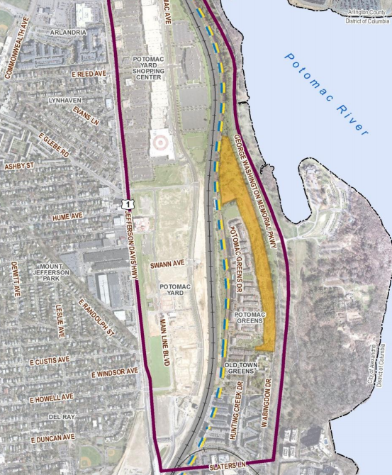
April 29, 2015 at 4:00 pm #1029001chris_sParticipantI looked at it again. I was basically right. They’re giving up all of the easement area except what they need for the metro station. The whole easement area is 15.27 acres. Easement area in orange:
 April 29, 2015 at 6:48 pm #1029019
scorchedearth
Participant@Terpfan 114674 wrote:
So basically they’re talking about the swamp to the right of the GWMP/left of Metro line? I presume their easement must go all the way down to 4MR, because if it’s just that little area behind the townhomes then there is no chance it’s 13.5 acres. When I used to live in those old garden style apartments next to it (off E Abingdon across from drycleaners), I just presumed that land was private with that little gravel path and small pond.
That’s a great trade then since nothing can ever be done to all of that land due to it’s status as basically all swamp.
The fact that it is a wetland does mean the land serves a purpose.
-
AuthorPosts
- You must be logged in to reply to this topic.