I was wondering…
Our Community › Forums › General Discussion › I was wondering…
- This topic has 19 replies, 10 voices, and was last updated 12 years, 3 months ago by
Tim Kelley.
-
AuthorPosts
-
February 25, 2013 at 8:42 pm #963272
Tim Kelley
ParticipantWe know the numbers for bikes and peds on the Custis, but not for other roads. I’d have to check in to see about general counts for certain roads in the area, but from what I understand our bike counting program is waaaay ahead of our car counting program.
February 25, 2013 at 8:46 pm #963274rcannon100
ParticipantIt’s a good question
February 25, 2013 at 8:50 pm #963278dasgeh
Participant@Tim Kelley 44681 wrote:
We know the numbers for bikes and peds on the Custis, but not for other roads. I’d have to check in to see about general counts for certain roads in the area, but from what I understand our bike counting program is waaaay ahead of our car counting program.
I heard that Arlington just got automatic counters for cars!
February 26, 2013 at 4:28 pm #963366Terpfan
Participanthttp://ddot.dc.gov/DC/DDOT/About+DDOT/Maps/Traffic+Volume+Maps/Traffic+Volume+Maps
There you go. 175,000 take the 14th St Bridge on average. Other counts for DC are on that map at the bottom, but it’s for 2010.
I don’t think we would win on that one although many trips are taken the neighboring George Mason Bridge.
February 26, 2013 at 4:48 pm #963374Tim Kelley
ParticipantHere’s some VDOT stuff if you want to wade into data: http://www.virginiadot.org/info/ct-trafficcounts.asp
And here’s some Arlington specific numbers that are easier to digest that were passed along to me:
- N Barton St north of Pershing Dr – 3,965 vehicles (2011)
- N Quincy St between 20th St N & 18th Rd N – 10,100 vehicles (2011)
- Washington Blvd west of N Randolph St – 14,000 vehicles (2009)
- Lee Hwy WB between N Lynn St & Ft Myer Dr – 7,950 vehicles (2011)
- Lee Hwy EB between Ft Myer Dr & N Lynn St – 21,820 vehicles (2011)
February 26, 2013 at 5:11 pm #963377dasgeh
ParticipantThanks, Tim.
Are the Arlington numbers avg. per day?
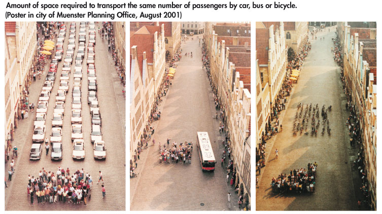
What about the space issue? I guess the real question is how much wider is a regular road (say Barton) than the Custis. Looking very quickly for Custis data, it looks like at the highest month (last June) there were an average of 66 bikes an hour at the “Rosslyn” counter. From above, Barton sees an average of 165 cars an hour. I’m guessing that the Barton is more than 2.5 times as wide as the Custis, so by measure of “Vehicle”/hour/sqft of asphalt, the Custis is more dense than Barton Street. I don’t know if it reaches the “density” of Quincy (hey! that count is right near me!)
Anyway, thanks.
February 26, 2013 at 5:15 pm #963378Tim Kelley
ParticipantSorry, I should have included that those numbers are 24-hour weekday averages.
February 26, 2013 at 5:28 pm #963379creadinger
Participant@dasgeh 44793 wrote:
I’m guessing that the Barton is more than 2.5 times as wide as the Custis, so by measure of “Vehicle”/hour/sqft of asphalt, the Custis is more dense than Barton Street.
It wouldn’t be sqft because you’re just looking at trail and road width correct? So just vehicle/hour/ft (width). Either way, I think this is a very interesting question and well worth it to go through the math to figure out how the Custis actually stacks up against actual roads. Maybe a strong case could be made for trail widening in the future.
February 26, 2013 at 5:32 pm #963380dasgeh
Participant@creadinger 44795 wrote:
It wouldn’t be sqft because you’re just looking at trail and road width correct? So just vehicle/hour/ft (width). Either way, I think this is a very interesting question and well worth it to go through the math to figure out how the Custis actually stacks up against actual roads. Maybe a strong case could be made for trail widening in the future.
That’s a good point. I was originally envisioning data that would cover a stretch of asphalt, but since the counters are at one point (at least on the trails), that doesn’t make sense. Also, if I understand road construction correctly, there’s a lot more going on (asphalt and other junk) under the top level of a road than of a trail.
February 26, 2013 at 5:35 pm #963381OutsideTheLaw
ParticipantVery interesting thread.
February 26, 2013 at 5:42 pm #963382Tim Kelley
ParticipantGillian–let me know if you want some hard numbers to work from. I may ask you to write a blog post though!
February 26, 2013 at 5:43 pm #963383creadinger
ParticipantThis, as with every other great scientific question is always limited by the quality of data unfortunately…. trying to sound philosophical, but not coming out right.
Yeah, in order to support trucks and other large vehicles roads are usually underlain with lots of compacted gravel. I would bet paved trails have some gravel, but a significantly thinner layer. If the data show that bike ‘density’ is far lower than neighboring roads we’ll of course have to suppress the results right? Haha.
Next step is someone needs to get their tape measure out and measure these roads/trails.
February 26, 2013 at 5:51 pm #963385dbb
ParticipantYou can get a view behind the drapes from some of the photos in this thread
It appears to be about 6 inches (maybe less) of compacted base (AKA gravel) topped with about 4 inches of asphalt.
If the trail was used like a road (with cars and stuff), it wouldn’t last long.
February 26, 2013 at 6:16 pm #963389mstone
ParticipantThis is why the trails have tree root problems more often than roads do.
February 26, 2013 at 6:30 pm #963391dbb
Participant@mstone 44805 wrote:
This is why the trails have tree root problems more often than roads do.
Yup. Because of motorist safety requirements (the steel boxes are not invincable) the trees are cleared back a couple of lane widths from the roadway. Would be a pretty special tree that could extend its roots that far just under the surface. Roadway runoff (salt, oil, etc) also contributes to the lack of trees. A 10 foot wide trail can probably be built in a 15 foot wide space. All in all, I can live with the roots in exchange for the trees and shade.
The depth of excavation for a roadway is much deeper as well, leaving no growing media for the roots within 12-18 inches of the bottom of the pavement. Not where you would want to live if you were a tree!
-
AuthorPosts
- You must be logged in to reply to this topic.