February 2015 Trail Conditions
Our Community › Forums › Road and Trail Conditions › February 2015 Trail Conditions
- This topic has 520 replies, 89 voices, and was last updated 10 years, 5 months ago by
consularrider.
-
CreatorTopic
-
February 1, 2015 at 8:05 pm #916422
PotomacCyclist
ParticipantThe weather isn’t that bad today. A slight chance of ice pellets, but nothing right now.
Rain all day on Monday. 40s most of the day. However, temperatures will drop off in the evening, below freezing. The rain is supposed to end by then, but the earlier rainfall could freeze over on Mon. night and Tue. morning.
The rest of the week looks clear with a high in the mid to upper 40s on Wed. and minimal chance of additional precipitation.
-
CreatorTopic
-
AuthorReplies
-
February 25, 2015 at 4:58 pm #1024034
S. Arlington Observer
Participant@Yggdrasil 109410 wrote:
[ATTACH=CONFIG]7937[/ATTACH]
W&OD just northwest of Columbia Pike. I was hoping that some of it had cleared and would allow us to pass to Bluemont Junction just fine — nope. Looks like the backroads and a Rt.50 crossing to Custis from the 4MR area are still necessary to get to DC from around here.
This is a huge help (especially the picture, I know the area well.) Looks like I’ll take an alternative at least to Columbia Pike. Dang. Was hoping to at least get today in before the next snow. Very much appreciate the insight.
February 25, 2015 at 4:59 pm #1024035hozn
Participant@vern 109411 wrote:
So, if I by-pass Park St. to Gallows, and then by-pass the WOD from Shreve to 29 I’m ok on slicks (but for maybe a few short portages)?
Saw you this a.m. on Van Buren.
Well, there was more snow on the trail in Reston than I remembered. E.g. along the golf course before Whiele, in other shady areas, that big stretch before Hunter Mill. From Hunter Mill to Vienna was almost completely passable (with at minimum a narrow strip of pavement).
From Park St. to Gallows there were the usual sections, so probably best to skip those, yeah. From Shreve to 29 I think the only real significant portion that was all ice was that first little hill near the tennis courts there. Generally through Falls Church there is was least a strip of pavement.
It’s hard to say with confidence; for some reason it’s hard to remember the trail conditions despite having just ridden it
") I guess despite best intentions, if it doesn’t disrupt my ride I’m unlikely to remember the significance of the ice/snow/etc.
I guess despite best intentions, if it doesn’t disrupt my ride I’m unlikely to remember the significance of the ice/snow/etc.Of course this may all be moot tomorrow due to snow.
Ah, that was you this AM. Makes sense now!
February 25, 2015 at 5:00 pm #1024036dasgeh
Participant@PStokes 109403 wrote:
Any recommendations on an ice free way into DC from the Custis Trail? The MVT and Roosevelt Bridge are not ridable. How is the 14th Street Bridge and MVT to the Four Mile Run trail?
@dasgeh 109357 wrote:
My normal commute is over the TR Bridge, but in the snow, I take the Memorial Bridge — > 110 Trail –> Marshall –> Meade, which becomes Lynn and takes you to the Intersection of Doom, as shown on this map.
No GWMP crossings, just one on-ramp, but I haven’t had problems with it (it’s worse on the Lincoln side of the bridge).
February 25, 2015 at 5:17 pm #1024041Yggdrasil
Participant@S. Arlington Observer 109414 wrote:
This is a huge help (especially the picture, I know the area well.) Looks like I’ll take an alternative at least to Columbia Pike. Dang. Was hoping to at least get today in before the next snow. Very much appreciate the insight.
Definitely impassable unless you’re rocking a fat bike and a really good health insurance plan. The whole trail was razor sharp ice daggers for as far as the eye could see. The rest of the roads and Custis are beautiful however.
February 25, 2015 at 5:29 pm #1024044Dickie
Participant@Tania 109396 wrote:
Dickie – how is the mile from Gallows to Virginia Lane (skinny slicks)? If I can get to Virginia Lane, then I can take Boomer2U’s route to the Custis. Otherwise I’d have to take Shreve from Gallows/29 and there’s zero shoulder…
Hey Tania, yeah, pretty much what Boomer said. I generally skip the Gallows intersection and take Lliff to Sandburg and then hit the WOD skipping about 100 yards of the trail and making for a much easier transition to the trail. The section from Sandburg to the 495 bridge is a bit dodgy with only a narrow strip of pavement showing. From there you have a decent amount of clear and dry pavement until you hit the top at Virginia Lane.
February 25, 2015 at 5:51 pm #1024045komorebi
Participant@worktheweb 109250 wrote:
I did this today, from pretty much where you’re starting, and it went well. I started out at the path from Rt 1 that connects to Washington Street by Hunting Towers — it is plowed and quite clear. From there I hung a left on the sidewalk (also cleared) and went left on Church Street then Right on Columbus. I took that all the way to the end, making a left on Powhattan then a left on Slaters and a right on the path on the Monroe Ave bridge (cleared). From there I stayed on the path going alongside Potomac Avenue, which is plowed all the way to E. Glebe. From there onto the road taking Potomac Ave to Crystal Drive (making a right) and taking that until it ends at 12th St South. Take that then the right at Long Bridge Drive until that ends at Boundary Channel. Take that under 395 (a bit past that there is a plowed sidewalk for most of the way) until the sidewalk on the access ramp to 27 (S Washington Blvd) — get on that sidewalk, if you go under a bridge, you went too far. From there you take the trail and after the first bridge, it gets icy, it might be best to walk, even with my studs I dismounted this morning, but it is only about 1/4 mile. You have a few at grade crossings to get to Memorial Bridge (which is cleared). From there you’re in DC. With the exception of that 1/4 mile section in ice, it is all plowed, and all on road. Not as pleasant as the MVT in normal conditions, but much nicer today.
Thanks for the detailed route description! Hearing that the Monroe Avenue bridge and the Potomac Avenue path had been cleared gave me the confidence to resume my morning commute today, after more than a week off. Actually, my colleagues should be the ones thanking you, because I’m much more focused and productive when I can bike to work.
In case anyone’s wondering: that 1/4 mile section is still hard-packed ice or crunchy ice shards. I saw one intrepid rider taking an alternate route on the grass next to the trail, but I walked it.
February 25, 2015 at 6:29 pm #1024049brendan
ParticipantRiding west of Gallows report (studded tires):
The segment from Cedar Lane up to just past Adahi Rd was more treacherous than it looked. The ice was just super slippery and I had to put my feet down several times. As was the segment right before the curve for the crossing of Park St. in Vienna. Got passed by a runner while flintstoning. Twice.
Also, obviously, Buckthorn Hill is problematic. I should have shifted lower heading up the hill so I ended up having to flintstone near the top, which took weight off the rear wheel, which made for some hilarity with all that bike. Almost a catastrophe, but still would have been a funny one.
I also wanted to take the downhill slow so I stopped at the top and realized I really didn’t want to go down at all on that ice. So I just flintstoned in the snow to the north of the trail. Really really slowly. All the way down.
Oddly enough, the segments through Reston into Herndon were good and bad but even the completely crusted over sections were pretty reasonable on studded tires.
Pedestrians were kind.
The ride back will be interesting tonight.
February 25, 2015 at 6:48 pm #1024051GB
Participant@brendan 109430 wrote:
Riding west of Gallows report (studded tires)
What was your total riding time and distance?
February 25, 2015 at 6:56 pm #1024052Participant@GB 109432 wrote:
What was your total riding time and distance?
Shaw -> Herndon, about 24 miles. 2:45 or so (ish? Forgot to check the clock when I left). Cargo bike, heavyish bags.
February 25, 2015 at 7:14 pm #1024058 GreenbeltParticipant
So finally there’s a way to get from Greenbelt/North College Park to DC on pavement and without riding in traffic. But it’s pretty convoluted! And there are a couple icy patches and some narrow bare trail areas where you have to slow way down or Flintstone a bit, on the MNCPPC (of course) maintained sections of the College Park trolley trail between Paint Branch parkway and Lakeland Ave. The trolley trail north of Lakeland and south of Paint Branch has been plowed by the City of College Park.
Here was my commute route this morning: https://www.strava.com/activities/259702774
February 25, 2015 at 9:03 pm #1024077Tom H
ParticipantFebruary 25, 2015 at 10:57 pm #1024090dbb
ParticipantLeft work a bit early and decided to try the MVT. It appears that spring may be nigh.
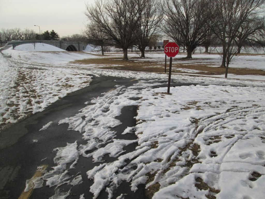
The turnoff from the bridge to the MVT
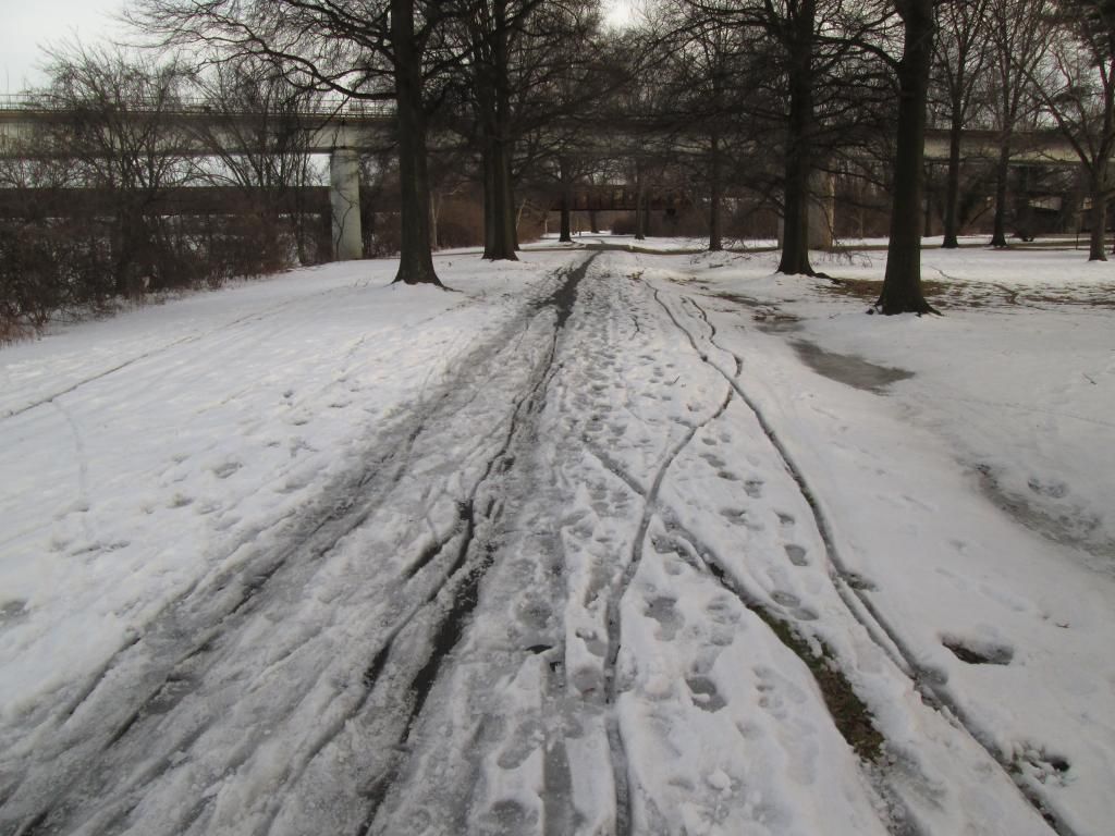
Under the bridges, the trail isn’t clear but it is getting better.
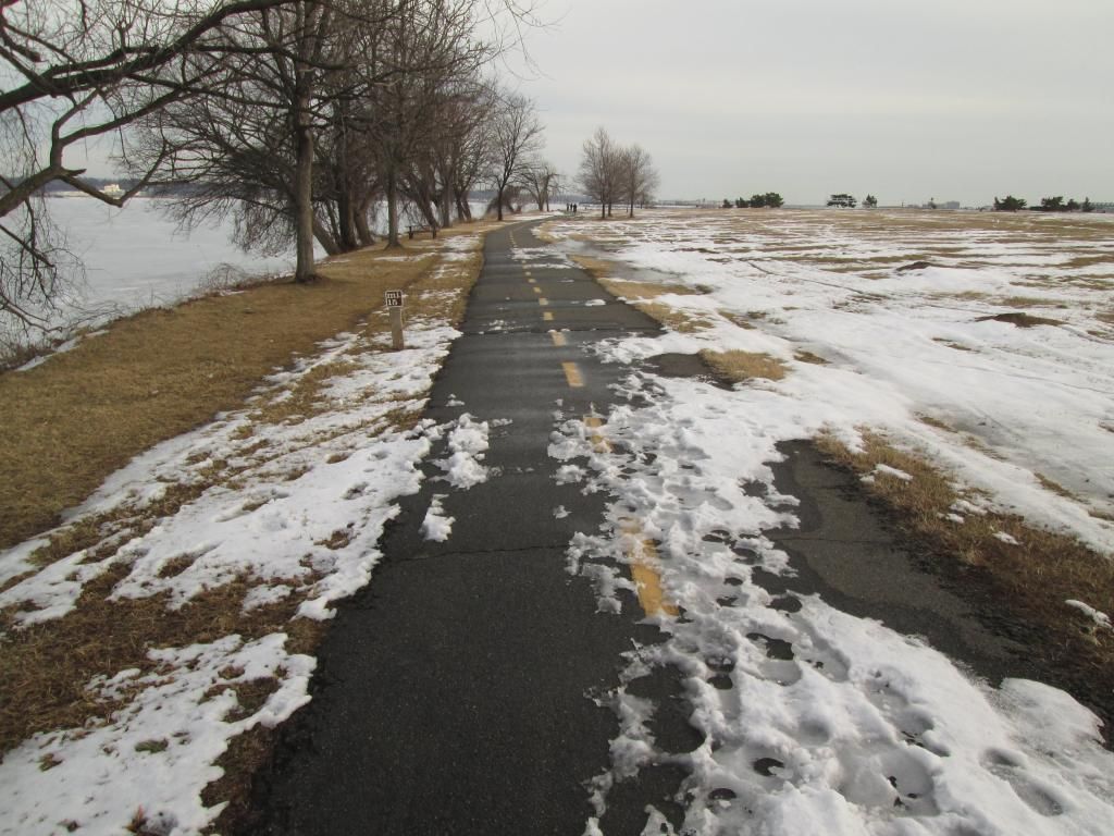
This is at MM 15 approaching Gravelly Point
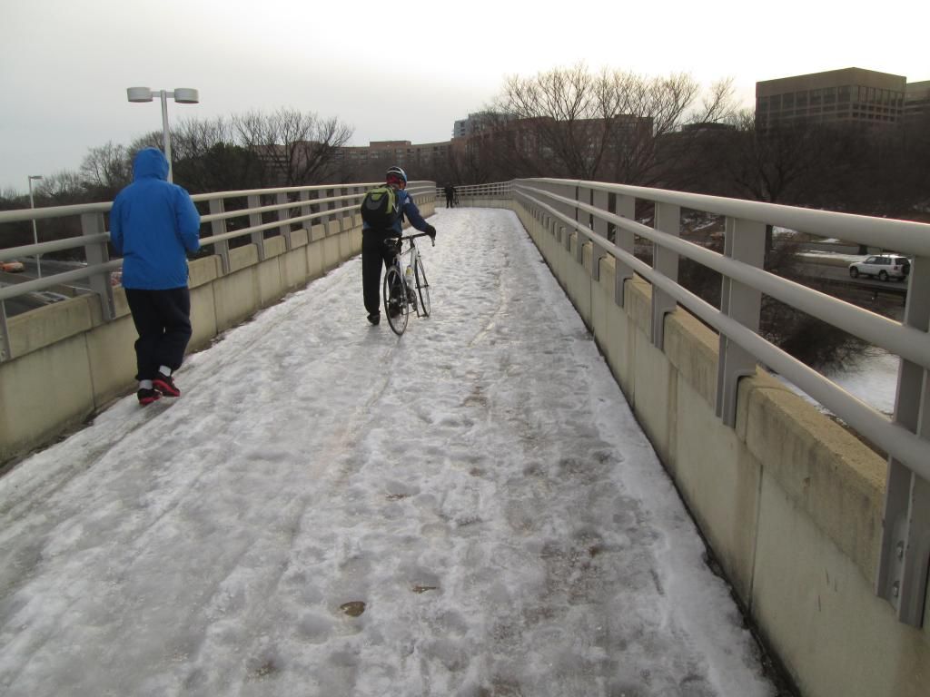
The ice on the north airport bridge was treacherous. The cyclist in the photo had narrow slicks and his bike was all over the place even though he was walking it.
Bottom line, if you are willing to walk a bit and flintstone some, the MVT may be open for business.
February 25, 2015 at 11:44 pm #1024092PStokes
ParticipantFrom North Arlington, the Custis trail is in good shape (thank you Arlington County), but the MVT is an icy mess and so was the Roosevelt Bridge, I had to walk the bike for 3/4 to 1 mile (with another intrepid commuter). I came back through Georgetown (not fun at rush hour) but the Key Bridge is clear and a good alternative to the Roosevelt.
February 26, 2015 at 12:22 am #1024096ParticipantPoof
February 26, 2015 at 1:03 am #1024097Ron
ParticipantMany thanks for the photos of the trails – a picture is truly worth a thousand words!!!!!!
-
AuthorReplies


- You must be logged in to reply to this topic.