Encourage NPS to fix the Trollheim & Maybe Do Other Stuff on and around TR Island
Our Community › Forums › General Discussion › Encourage NPS to fix the Trollheim & Maybe Do Other Stuff on and around TR Island
- This topic has 20 replies, 10 voices, and was last updated 8 years ago by
 chris_s.
-
CreatorTopic
-
August 3, 2017 at 3:04 pm #919609chris_sParticipant
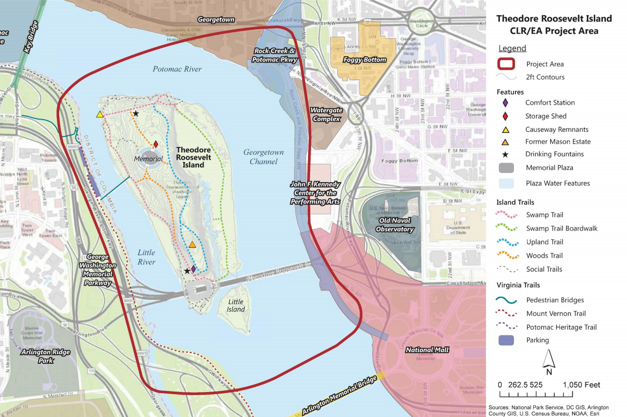
The National Park Service is starting the Environmental Review Process for doing potential upgrades to TR Island and the area directly surrounding it. One of the potential improvements: Rehabilitate Bridge 31 on Mt. Vernon Trail of
the George Washington Memorial Parkway for safer pedestrian/bicycle travel. What NPS calls “Bridge 31” you may know as: The Trollheim.NPS is accepting comments here on their website through September 8th. They’re also (bizarrely) holding an Open House TODAY from 12:30pm-4:00pm on TR Island itself. So you know, if you’ve got nothing better to do this afternoon, feel free to roll on over.
I encourage everyone to share their comments here as well so that folks can crib from eachother. I’ll be taking a “Yes fix Bridge 31 and ALSO do all of these other things” approach to my comments. Anything inside this lovely red box is fair game:
-
CreatorTopic
-
AuthorReplies
-
August 3, 2017 at 3:24 pm #1074104
huskerdont
Participant@chris_s 163639 wrote:
The National Park Service is starting the Environmental Review Process for doing potential upgrades to TR Island and the area directly surrounding it. One of the potential improvements: Rehabilitate Bridge 31 on Mt. Vernon Trail of
the George Washington Memorial Parkway for safer pedestrian/bicycle travel. What NPS calls “Bridge 31” you may know as: The Trollheim.NPS is accepting comments here on their website through September 8th. They’re also (bizarrely) holding an Open House TODAY from 12:30pm-4:00pm on TR Island itself. So you know, if you’ve got nothing better to do this afternoon, feel free to roll on over.
I encourage everyone to share their comments here as well so that folks can crib from eachother. I’ll be taking a “Yes fix Bridge 31 and ALSO do all of these other things” approach to my comments. Anything inside this lovely red box is fair game:
The TR Bridge itself is inside that box; is that also fair game? Because if it is, there’s a pony out there I want.
i will comment either way.
August 3, 2017 at 3:33 pm #1074106chris_sParticipant@huskerdont 163643 wrote:
The TR Bridge itself is inside that box; is that also fair game? Because if it is, there’s a pony out there I want.
i will comment either way.
You can comment on it, but I suspect the NPS response will be “that’s DDOT’s jurisdiction”. It can’t hurt.
August 3, 2017 at 3:48 pm #1074109 bentbike33Participant
How about connecting the pedestrian/bike facility on the SOUTH side of the TR bridge (raise your hand if you knew such a thing existed) to something, anything, on the Virginia side, like maybe the MVT (which should be inside the red box). Now if you get on that path, easily accessible from the DC side, it dumps you into a wilderness on the wrong side of the GW Parkway. With better access, making the TR bridge bike/ped crossings one-way corresponding to the flow of cars could be considered as a way to reduce mid-bridge conflicts and encourage more use.
August 3, 2017 at 3:57 pm #1074110creadinger
ParticipantSomeone should post a link to the Trollheim crash thread, so they can start getting an idea of how many victims there are. I’ll leave the honors for someone who has actually laid down hard on the slippery boards wondering “WTF?!”
August 3, 2017 at 5:01 pm #1074116ginacico
Participant@bentbike33 163647 wrote:
How about connecting the pedestrian/bike facility on the SOUTH side of the TR bridge (raise your hand if you knew such a thing existed) to something, anything, on the Virginia side, like maybe the MVT (which should be inside the red box). Now if you get on that path, easily accessible from the DC side, it dumps you into a wilderness on the wrong side of the GW Parkway.
???
Well, I’ll be damned.
[ATTACH=CONFIG]15305[/ATTACH]
August 3, 2017 at 5:12 pm #1074118 ShawnoftheDreadParticipant
@bentbike33 163647 wrote:
How about connecting the pedestrian/bike facility on the SOUTH side of the TR bridge (raise your hand if you knew such a thing existed) to something, anything, on the Virginia side, like maybe the MVT (which should be inside the red box). Now if you get on that path, easily accessible from the DC side, it dumps you into a wilderness on the wrong side of the GW Parkway. With better access, making the TR bridge bike/ped crossings one-way corresponding to the flow of cars could be considered as a way to reduce mid-bridge conflicts and encourage more use.
One, I’m not sure I’d characterize the south side as “easily accessible” in DC. Randomly, surprisingly, sure.
Two, one way for each side would be terrible, as the D.C. sides are in very different locations.
Sent from my iPhone using Tapatalk
August 3, 2017 at 5:34 pm #1074119ParticipantDone, though I just realized I failed to mention the “trail” between the Kennedy Center and the river. I did mention that the entire MVT except for that section newly redone by the TR Island parking lot is bumpy, divoted, and too narrow to be safe for a heavily used recreational/commuter corridor.
If the Memorial Bridge underpass were in that red box, I would have asked for another pony.
August 3, 2017 at 5:34 pm #1074120bentbike33Participant@ShawnoftheDread 163658 wrote:
One, I’m not sure I’d characterize the south side as “easily accessible” in DC. Randomly, surprisingly, sure.
While it is no biketopia, at least there is a paved trail on the DC side that connects the southside bridge path to other infrastructure.
@ShawnoftheDread 163658 wrote:
Two, one way for each side would be terrible, as the D.C. sides are in very different locations.
A thought experiment. Not really my neighborhood.
My real point is: we have a perfectly serviceable (although admittedly not ideal) piece of segregated infrastructure built and paid for, but it is useless and unused because somebody forgot to connect the other end to anything.
August 3, 2017 at 7:06 pm #1074127ursus
Participant@huskerdont 163659 wrote:
Done, though I just realized I failed to mention the “trail” between the Kennedy Center and the river. I did mention that the entire MVT except for that section newly redone by the TR Island parking lot is bumpy, divoted, and too narrow to be safe for a heavily used recreational/commuter corridor.
If the Memorial Bridge underpass were in that red box, I would have asked for another pony.
FWIW, I also think that they did an excellent job of redoing the Humpback Bridge and its approaches a few years ago. Remember how narrow the bridge itself was and how steep the western approach was?
August 3, 2017 at 7:26 pm #1074129 Steve OParticipant
@bentbike33 163647 wrote:
How about connecting the pedestrian/bike facility on the SOUTH side of the TR bridge (raise your hand if you knew such a thing existed)
Hand raised.
In fact, one of my all-time favorite signs–shown here–is on that facility. For years I had hoped to take its picture, and then at Obama’s first inauguration, we walked across the TR Bridge, which was closed to cars, and I made sure I did.I do wonder exactly how one is supposed to “Begin” your ride here. Dropped in by helicopter?
[ATTACH=CONFIG]15306[/ATTACH]August 3, 2017 at 7:30 pm #1074130Steve OParticipant@creadinger 163648 wrote:
Someone should post a link to the Trollheim crash thread, so they can start getting an idea of how many victims there are. I’ll leave the honors for someone who has actually laid down hard on the slippery boards wondering “WTF?!”
If not you, then you are in the minority. I would guess at least 75% of bicyclists who have ridden regularly on that bridge, and that I have asked, have gone down at least once. Including me.
August 3, 2017 at 7:35 pm #1074131bentbike33Participant@Steve O 163669 wrote:
I do wonder exactly how one is supposed to “Begin” your ride here. Dropped in by helicopter?
Easy-peasy: take the lane on eastbound 50 anywhere in Arlington, take the TR bridge ramp (means taking a left lane on 50 at some point prior) and when you get to the sign, stop, dismount, hoist bike over guardrail and place on sidewalk, climb over the railing, remount, and proceed into DC.
August 3, 2017 at 8:01 pm #1074133scoot
Participant@bentbike33 163671 wrote:
Easy-peasy: take the lane on eastbound 50 anywhere in Arlington, take the TR bridge ramp (means taking a left lane on 50 at some point prior) and when you get to the sign, stop, dismount, hoist bike over guardrail and place on sidewalk, climb over the railing, remount, and proceed into DC.
If the merge across 50 sounds a little scary, simply use the left entrance from 10th or N Courthouse.
August 3, 2017 at 8:31 pm #1074137chris_sParticipant@bentbike33 163647 wrote:
How about connecting the pedestrian/bike facility on the SOUTH side of the TR bridge (raise your hand if you knew such a thing existed) to something, anything, on the Virginia side, like maybe the MVT (which should be inside the red box). Now if you get on that path, easily accessible from the DC side, it dumps you into a wilderness on the wrong side of the GW Parkway. With better access, making the TR bridge bike/ped crossings one-way corresponding to the flow of cars could be considered as a way to reduce mid-bridge conflicts and encourage more use.
The Rosslyn Sector plan calls for connecting the South Side of the TR bridge to a trail to Rosslyn and to Iwo Jima. It’d be great to get NPS onboard with that.
[ATTACH=CONFIG]15307[/ATTACH]
August 3, 2017 at 8:54 pm #1074140zsionakides
Participant@bentbike33 163647 wrote:
How about connecting the pedestrian/bike facility on the SOUTH side of the TR bridge (raise your hand if you knew such a thing existed) to something, anything, on the Virginia side, like maybe the MVT (which should be inside the red box). Now if you get on that path, easily accessible from the DC side, it dumps you into a wilderness on the wrong side of the GW Parkway. With better access, making the TR bridge bike/ped crossings one-way corresponding to the flow of cars could be considered as a way to reduce mid-bridge conflicts and encourage more use.
I would rather see one the pedestrian paths re-purposed as space for the highway and the other side doubled in size. If you took away the “shoulder” space as well, you could probably fit about a 9-10′ wide trail across most the bridge. Raise the barriers up on either side and it’s a comparable facility to the 14th st bridge. If we’re going to spend money on an approach to the south side, which isn’t cheap, it would be better to get a better trail instead.
Having one-way facilities doesn’t deal with passing pedestrians on such a narrow path.
-
AuthorReplies
- You must be logged in to reply to this topic.