DC Area Regional Bike Map
Our Community › Forums › Where to ride? › DC Area Regional Bike Map
- This topic has 27 replies, 11 voices, and was last updated 9 years, 5 months ago by
 chris_s.
-
AuthorPosts
-
December 22, 2015 at 4:02 pm #1043267
 lordofthemarkParticipant
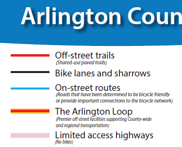
Even these jurisdictions are not completely consistent as to format
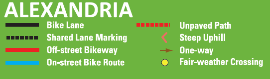
Dotted black lines appear to be sharrows in Alexandria (following DC practice, I guess, distinguishing them from both bike lanes and designated bike routes with no on road paint) but in Arlington sharrows are still solid black lines, same as the bike lanes.
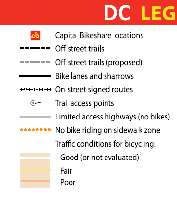
Also DC marks PBLs with extra thick black lines (at least 15th street – L and M and Pa do not show because downtown details are not shown on the District wide map) but in Arlington the PBLs are the same width as regular bike lanes. This does not come up for Alexandria, which does not yet have any PBL’s.
December 22, 2015 at 4:59 pm #1043278S. Arlington Observer
Participant@chris_s 130158 wrote:
I finally got sick of their not being a regional bike map, so I hacked together my own. Behold, Frankenmap – a combination of the Arlington, Alexandria, DC & Takoma Park bike maps, all laid over top of an OpenStreetMaps base. Let me know: 1) what you think 2) if it is useful to you 3) any suggestions for improvement.
Wow. Thanks.
December 22, 2015 at 6:01 pm #1043289Arlingtonrider
ParticipantChris, this is great. Thanks! It would be awesome if they could all agree on color keys (my vote would be with Arlington’s, fwiw.)
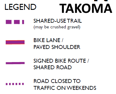
December 22, 2015 at 6:36 pm #1043293chris_sParticipantArlington & Alexandria are reasonably consistent, but DC & Takoma are very different.
 December 22, 2015 at 6:38 pm #1043295
Tim Kelley
Participant@chris_s 130189 wrote:
The lack of standardization is really quite something:
Arlington and Alexandria use the same color scheme, which is what the Capital Bikeshare station kiosk maps use. We lobbied DC to use the same scheme but they refused.
December 22, 2015 at 6:43 pm #1043297chris_sParticipant@lordofthemark 130164 wrote:
(at least 15th street – L and M and Pa do not show because downtown details are not shown on the District wide map)
I’m pretty sure L and M just aren’t shown because DC’s bike map is crazy out-dated. I’m showing the downtown detail version of the map in the areas where it exists.
December 22, 2015 at 6:45 pm #1043299chris_sParticipantIf any Android users are feeling adventurous: Frankenmap App DL (you’ll need to have “allow installation of apps from unknown sources” enabled on your phone to be able to install)
December 22, 2015 at 7:13 pm #1043305chris_sParticipantFairfax and Montgomery Counties now included. I have removed Takoma Park now because the Montgomery County data seems to completely duplicate it.
December 22, 2015 at 7:42 pm #1043312CaseyKane50
ParticipantYou did a nice job of bringing all of the maps together – thank you!
One glitch I noted with the base Arlington map – it shows the Holmes Run Trail west of Chambliss as being unpaved. The Alexandria map just notes that the trail runs for another 1.5 miles to Columbia Pike and the Fairfax map notes that it is a secondary route, which may contain fair-weather crossings.
[ATTACH=CONFIG]10282[/ATTACH]
In fact, the trail is paved from Chambliss to Columbia Pike with several fair-weather crossings. Probably need Arlington to update their map
December 22, 2015 at 7:47 pm #1043314ParticipantDecember 22, 2015 at 8:17 pm #1043315 kwarkentienParticipant
This is great Chris! Thanks for taking the initiative to pull this all together.
December 22, 2015 at 8:52 pm #1043318chris_sParticipantA couple more updates:
1) Now that Fairfax and Montgomery County bike facility data is on there, I’ve wiped out the other jurisdictions minimalist basemap from beneath them. This should take care of the Holmes Run unpaved problem, among others.
2) I’ve switch to MapBox streets as the default basemap which is a lot prettier than the standard OSM basemap.None of the above have made it into the test android app yet.
December 29, 2015 at 3:00 am #1043528chris_sParticipantVERSION 2, complete re-write:
No more panning over the paper version of maps, this version is entirely based off of the jurisdictions’ GIS data. This allows me to (mostly) create a consistent color scheme:GREEN = cycletracks (protected bike lanes)
BLACK = bike lanes
DASHED BLACK = sharrows
RED = trails
DASHED RED = unpaved trails
BLUE = suggested streetsCaveats:
1) Fairfax provides on-street facility data that is very different from everyone elses. Instead of facility information, they provide a grade for “bicycle level of service” (BLOS). I am showing anything that has a BLOS of A or B as a blue “suggested street” and ignore everything else.
2) I’m probably showing some unpaved trails that aren’t worth showing at all.December 29, 2015 at 7:42 am #1043529 cvcalhounParticipant
A few picky comments on what is a great project, from the perspective of a Montgomery County resident:
Any chance of getting more street names on here? In my neighborhood, the main street (Old Georgetown Road) has the name of the road on it. However, most of the streets that have sharrows on them do not have names on the map. This makes it hard for even a neighborhood resident like me to figure out which streets have sharrows, and the problem would be even worse for someone not from this area.
You may also want to add trail names. If someone is close to a trail but not sure exactly where it is, it’s a lot easier to ask for the Georgetown Branch Trail than for “that trail that goes from downtown Bethesda to somewhere in the vicinity of Silver Spring.”
Also, where there are sharrows on a one-way street (e.g., on Woodmont Avenue south of Old Georgetown), it would be helpful to indicate this. We really don’t want to encourage salmoning!
Finally, I’m noticing that Woodglen Drive between Edson Lane and Nicholson Lane is shown as having a sharrow on Woodglen and a paved trail to the east of Woodglen. It was apparently at one point supposed to get both, but they were never actually put in place. Instead, it has a cycle track/protected bike lane on the west side of Woodglen that connects the paved Bethesda Trolley Trail south of Edson to the paved trail/sidewalk north of Nicholson. I’m not sure whether you are working from a slightly out-of-date map or whether something else is going on. However, since it is Montgomery County’s only cycle track, we have to publicize it!
Again, I think this map is a great idea. I’d just like to see a few improvements to make it more useful.
December 29, 2015 at 1:42 pm #1043536chris_sParticipant@cvcalhoun 130455 wrote:
A few picky comments on what is a great project, from the perspective of a Montgomery County resident:
THANK YOU!
@cvcalhoun 130455 wrote:
Any chance of getting more street names on here?
DONE!
@cvcalhoun 130455 wrote:
You may also want to add trail names.
DONE!
@cvcalhoun 130455 wrote:
Also, where there are sharrows on a one-way street (e.g., on Woodmont Avenue south of Old Georgetown), it would be helpful to indicate this. We really don’t want to encourage salmoning!
Hmmm…let me see what I can do.
@cvcalhoun 130455 wrote:
I’m not sure whether you are working from a slightly out-of-date map or whether something else is going on. However, since it is Montgomery County’s only cycle track, we have to publicize it!
I’m working from the latest on MoCo’s GIS website, so I’m guessing they haven’t uploaded an updated GIS file (clearly they’ve updated their GIS as their own online bikemap has the cycletrack on it). I’ve worked around the bad data so that the cycletrack displays and the non-existent trail and sharrows are hidden.
-
AuthorPosts
- You must be logged in to reply to this topic.