Bike trail at Jefferson – Part 3 of 3
Our Community › Forums › Road and Trail Conditions › Bike trail at Jefferson – Part 3 of 3
- This topic has 18 replies, 10 voices, and was last updated 12 years, 6 months ago by
mstone.
-
CreatorTopic
-
February 2, 2013 at 12:07 pm #912813
dbb
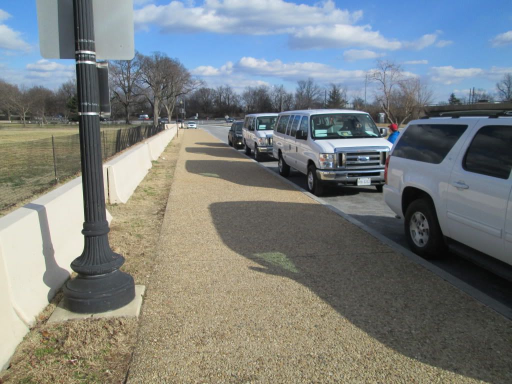
ParticipantThe two crosswalks (the first is by the CaBi docks and the second is further east) have straight box style curb cuts. We discussed the potential for replacing them with a flared curb cut similar to the ones across East Basin Drive. Thoughts?

If you’ve not noticed, as you come down from the bridge you see no signs or notices that tell you that East Basin Drive is a one-way street. I’d hazard a guess the lack of signs would be grounds for dismissing any tickets for salmoning to the east. They may take the existing signs (that tell the two park police officers that park across the street the road is one-way) and install signs facing the cyclists. Look at the first photo in the “1 of 3” posting in this series.

I highlighted the challenges with crossing East Basin Drive and getting on the sidewalk during tourist season. We discussed the possibility for converting the “no standing or stopping” parking area into a 15th Street cycletrack style bike lanes. The cycletrack would extend for the block and would deliver cyclists to the curb cut east of the Jefferson driveway. For that to work would require active enforcement regarding the “No stopping or standing” prohibition.
Another idea to deconflict the trail in front of the Jefferson (that one block) was to extend the asphalt trail on the point of land between East Basin Drive and the I-395 on ramp. While it would reduce salmoning in front of the memorial, it would push the crosswalk to a location with slightly reduced sightlines. It is shown in the Google sat photo as a crudely drawn line.

-
CreatorTopic
-
AuthorReplies
-
February 2, 2013 at 12:44 pm #961649
Hancockbs
ParticipantI agree that the curbing/transition and parked vehicles are the worst hazards here. The transitions are also very slick when wet. I would like to see a two way bike lane from that transition all the way to the crosswalk near the entrance to Hains Point, continuing to the Case bridge path, but I don’t expect that to happen. Thanks for tackling this and fir asking for input.
February 2, 2013 at 12:58 pm #961651mstone
ParticipantThose square curb cuts are getting very popular, which is annoying. Whatever agency approved them nationally really needs to go back to the drawing board. I think they’re the cheapest option, which it’s why the road people like them, but they just don’t work well.
February 2, 2013 at 2:52 pm #961641bobco85
ParticipantThis is what I had in mind, a modification of dbb’s design.
Here’s what I came up with:[ATTACH=CONFIG]2387[/ATTACH]
Considering that the path would be mostly used by cyclists who would inevitably cross the street diagonally, I changed the crosswalk with that in mind. There would also be no reason to have the middle crosswalk, so I photoshopped that out. I also sent the path around the tree, whatever that weird gas line looking thing is, and the gutter drain. My only concern would be with the sight lines for people traveling westward.
February 2, 2013 at 2:58 pm #961642Participant@bobco85 42976 wrote:
This is what I had in mind, a modification of dbb’s design.
Here’s what I came up with:
Ladies and gentlemen of the forum. I stand humbled before you at the awesomeness of Bobco85’s drawing prowess! He captured the idea far more elegantly than my earlier attempt.
February 2, 2013 at 5:32 pm #961628eminva
ParticipantI am only an occasional Jefferson Memorial area rider so I defer to the wisdom of others. However, HUGE THANKS to dbb for his persistence, patience and attention to this longstanding and thorny problem.
Liz
February 3, 2013 at 3:30 pm #961603NickBull
Participant@bobco85 42976 wrote:
This is what I had in mind, a modification of dbb’s design.
Here’s what I came up with:[ATTACH=CONFIG]2387[/ATTACH]
Considering that the path would be mostly used by cyclists who would inevitably cross the street diagonally, I changed the crosswalk with that in mind. There would also be no reason to have the middle crosswalk, so I photoshopped that out. I also sent the path around the tree, whatever that weird gas line looking thing is, and the gutter drain. My only concern would be with the sight lines for people traveling westward.
I think this increases the hazard for people heading westward. You still have oncoming pedestrians & cyclists coming along the sidewalk next to the concrete barrier. Now instead of being able to check that the near lane of the parkway is clear, then ride a block where you can double-check that second lane, instead you have to check that both lanes are clear because you are forced across right at that point. As you mention the sight lines are bad there. Thus, coming westward, I would still want to use the “middle crosswalk” that you are “removing”. Coming eastward I would take your proposed new route. It solves the problem of choosing between getting on the sidewalk or salmoning, and as you ride eastward you have plenty of time to check that the oncoming parkway is clear (and can check for pedestrians and bikes on the other side of the road as you ride along).
I never noticed that there is no signage indicating that it’s a one-way road, but that’s probably a good idea to have.
Nick
February 3, 2013 at 6:14 pm #961599Participant@NickBull 43021 wrote:
I think this increases the hazard for people heading westward. You still have oncoming pedestrians & cyclists coming along the sidewalk next to the concrete barrier. Now instead of being able to check that the near lane of the parkway is clear, then ride a block where you can double-check that second lane, instead you have to check that both lanes are clear because you are forced across right at that point. As you mention the sight lines are bad there. Thus, coming westward, I would still want to use the “middle crosswalk” that you are “removing”. Coming eastward I would take your proposed new route. It solves the problem of choosing between getting on the sidewalk or salmoning, and as you ride eastward you have plenty of time to check that the oncoming parkway is clear (and can check for pedestrians and bikes on the other side of the road as you ride along).
I never noticed that there is no signage indicating that it’s a one-way road, but that’s probably a good idea to have.
Nick
Maybe there could be sharrows in the right lane from the Maine/15th intersection (that is in dire need of road work) to East Basin Dr to account for people heading west like this: Bike sharrows.
It might make it easier for westbound cyclists to get into the left part of the lane to be in position to get on the trail.
That said, the part I hate about this is that eastbound cyclists are still going to end up on the sidewalk going opposite vehicular traffic a few feet away.
P.S. – @dbb, thank you for your kind words. I will try and continue this for other projects because, really, playing in Photoshop is fun for me, and I like to help in the ways I can.
February 3, 2013 at 7:21 pm #961591KLizotte
Participant@dbb 42962 wrote:
The two crosswalks (the first is by the CaBi docks and the second is further east) have straight box style curb cuts. We discussed the potential for replacing them with a flared curb cut similar to the ones across East Basin Drive. Thoughts?
No brainer. NPS please fix!!!
February 3, 2013 at 7:22 pm #961592Participant@dbb 42962 wrote:
If you’ve not noticed, as you come down from the bridge you see no signs or notices that tell you that East Basin Drive is a one-way street. I’d hazard a guess the lack of signs would be grounds for dismissing any tickets for salmoning to the east. They may take the existing signs (that tell the two park police officers that park across the street the road is one-way) and install signs facing the cyclists. Look at the first photo in the “1 of 3” posting in this series.
Another no brainer. I’ve seen tourists accidentally go the wrong way.
February 3, 2013 at 7:23 pm #961593Participant@dbb 42962 wrote:
I highlighted the challenges with crossing East Basin Drive and getting on the sidewalk during tourist season. We discussed the possibility for converting the “no standing or stopping” parking area into a 15th Street cycletrack style bike lanes. The cycletrack would extend for the block and would deliver cyclists to the curb cut east of the Jefferson driveway. For that to work would require active enforcement regarding the “No stopping or standing” prohibition.
I guess I’ve never noticed any signs stating it’s a no standing/stopping area but does that mean the vans are parked illegally above?! Wow. And all those tour buses that stop there? And cyclists get ticketed for not putting a foot down at the stop signs at Hain’s Pt. Does not compute…
Anyway….
February 3, 2013 at 7:39 pm #961590ParticipantMost motorists don’t appear to have noticed them either.
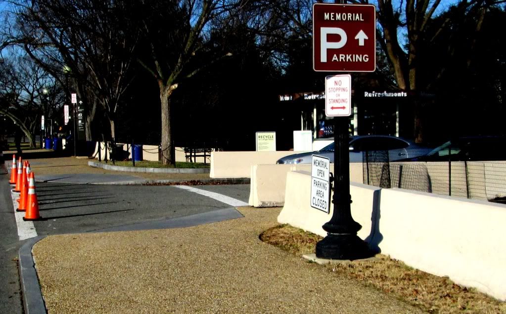
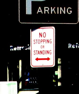
Here are a couple of photos that show the front of the signs you can see in the previous post
February 3, 2013 at 7:48 pm #961588Participant@dbb 42962 wrote:
Another idea to deconflict the trail in front of the Jefferson (that one block) was to extend the asphalt trail on the point of land between East Basin Drive and the I-395 on ramp. While it would reduce salmoning in front of the memorial, it would push the crosswalk to a location with slightly reduced sightlines. It is shown in the Google sat photo as a crudely drawn line.
Hmmmm….the only thing I don’t like about your’s or bobcat’s proposals is the poor sight lines since cars are coming pretty quickly around that curve, esp if they didn’t mean to take that exit and think they are heading to the bridge.
As another poster noted above, heading eastbound the sightlines are good. Heading westbound is more tricky because you would need to look over your shoulder to look for cars, and pay attention to oncoming cyclists since you would need to cross their lane to get into the crosswalk. And then there is the issue of all the pedestrians along that sidewalk. There aren’t many peds now but in a few months…..
Perhaps NPS could try to put in signs and markings to direct peds to the inner trail by the Jefferson Memorial?
A potential way to improve sightlines and cut down on conflicts is to put in a turning “bump out” (not sure what the technical term is for these things). In a way, we already have one with the driveway there. Ideally cyclists heading westbound would be directed to pull into the bump out so that they become perpendicular to the street and can safely stop out of the way of eastbound cyclists and pedestrians before going into the crosswalk to get to the newly extended trail on the other side. Again, the trail may have to bifurcated to force cyclists to do this as some will try to cut across diagonally at high speeds putting other users at risk. If I’m gonna cross there I want to have a good place to slow down/stop and be able to check both directions without having to look over my shoulder. Also remember that Cabi riders probably don’t have the best riding skills either.
Unfortunately I’m unable to find a photo of a “bump out” in the real world; I know they have them in Montreal. Here’s a crudely edited pic of what I mean.
[ATTACH=CONFIG]2390[/ATTACH]
February 3, 2013 at 10:04 pm #961585Participant@KLizotte 43036 wrote:
Hmmmm….the only thing I don’t like about your’s or bobcat’s proposals is the poor sight lines since cars are coming pretty quickly around that curve, esp if they didn’t mean to take that exit and think they are heading to the bridge.
As another poster noted above, heading eastbound the sightlines are good. Heading westbound is more tricky because you would need to look over your shoulder to look for cars, and pay attention to oncoming cyclists since you would need to cross their lane to get into the crosswalk. And then there is the issue of all the pedestrians along that sidewalk. There aren’t many peds now but in a few months…..
Perhaps NPS could try to put in signs and markings to direct peds to the inner trail by the Jefferson Memorial?
A potential way to improve sightlines and cut down on conflicts is to put in a turning “bump out” (not sure what the technical term is for these things). In a way, we already have one with the driveway there. Ideally cyclists heading westbound would be directed to pull into the bump out so that they become perpendicular to the street and can safely stop out of the way of eastbound cyclists and pedestrians before going into the crosswalk to get to the newly extended trail on the other side. Again, the trail may have to bifurcated to force cyclists to do this as some will try to cut across diagonally at high speeds putting other users at risk. If I’m gonna cross there I want to have a good place to slow down/stop and be able to check both directions without having to look over my shoulder. Also remember that Cabi riders probably don’t have the best riding skills either.
Unfortunately I’m unable to find a photo of a “bump out” in the real world; I know they have them in Montreal. Here’s a crudely edited pic of what I mean.
[ATTACH=CONFIG]2390[/ATTACH]
Hi, from your bump out, you can’t really see very well to the left, and you’ve got pedestrians and bikes potentially going both directions — the oncoming ones for obvious reasons, plus the ones coming up from behind you and don’t want to get slowed down into a bump out, so they just jump the curb or go in the wrong lane. So from the bump-out, you have to look four directions at once–the parkway, oncoming pedestrians and cyclists, pedestrians and cyclists coming up from behind, and pedestrians and cyclists crossing in the new crosswalk from the other side of the parkway. From my perspective, the bump-out just makes things more dangerous.
I’ve gone through this intersection every work day for a decade, both directions. The biggest hazards in my experience are the orange cones, which appeared only about two years ago. Next most dangerous: when you are going westbound, oncoming bikes, either on the bikepath or in the “salmon” lane. But the oncoming bikes have right of way, so you just have to slow down and let them through. The main thing that makes them actively dangerous is that I’ve had a number of near-misses with cyclists at night who had no lights on. Anyway, once you’ve made the crossing from the sidewalk to the “near” lane of the parkway, then there is plenty of time to look for traffic in the second lane before moving over to the path to the bridge. Well, except for cherry blossom season when the parked buses mean there is little room to move over. But now that we all know that it’s illegal to stop or stand there, I’m sure that that lane will be clear for this year’s cherry blossom season
")
I guess what I’m saying is: Let’s not spend a vast amount of money to extend the bike trail, only to make the whole exercise more difficult and accident prone.
The “sharrows” idea has some merit since maybe it would help remind motorists that bikes have the right to use that stretch of road. But I think I’d still generally rather stick to the sidewalk. Drivers are intent on getting home at maximum speed, and I’ve had a number of them pass me very aggressively when I’ve gone in the road along there. Frankly, I don’t think those drivers would be the slightest bit intimidated by the sharrows unless there was some serious enforcement
So if money is to be spent, I would favor widening the section heading up to the bridge, as discussed elsewhere. And a second priority would be making a pedestrian walkway on the “inside” of the concrete barrier and routing the pedestrians that way. Or make a clear bike path with divider lines and “no pedestrians” signs. Separating pedestrians and cyclists in that section would be helpful.
Oh, and fix the square curb cuts with the slick slopes, those are dangerous, too.
Nick
February 3, 2013 at 11:55 pm #961584Participant@NickBull 43039 wrote:
Hi, from your bump out, you can’t really see very well to the left, and you’ve got pedestrians and bikes potentially going both directions — the oncoming ones for obvious reasons, plus the ones coming up from behind you and don’t want to get slowed down into a bump out, so they just jump the curb or go in the wrong lane. So from the bump-out, you have to look four directions at once–the parkway, oncoming pedestrians and cyclists, pedestrians and cyclists coming up from behind, and pedestrians and cyclists crossing in the new crosswalk from the other side of the parkway. From my perspective, the bump-out just makes things more dangerous. Nick
I don’t see why you would have to be concerned with what is going on behind you. Just ahead and both sides which isn’t any different than it is now.
I finally found some pics of what other cities have so hopefully what I’m proposing is clearer:
[ATTACH=CONFIG]2391[/ATTACH]
[ATTACH=CONFIG]2392[/ATTACH]
February 4, 2013 at 12:05 am #961583Participant@KLizotte 43040 wrote:
I don’t see why you would have to be concerned with what is going on behind you. Just ahead and both sides which isn’t any different than it is now.
I finally found some pics of what other cities have so hopefully what I’m proposing is clearer:
[ATTACH=CONFIG]2391[/ATTACH]
[ATTACH=CONFIG]2392[/ATTACH]
By “behind you” I mean coming up the path that was behind you, though once you’re in the bump out it is now on your left. So you have to look left for the guy who was coming down the path behind you; look right for the pedestrians and bicycle coming down the sidewalk; don’t forget to look for bike salmon coming around illegally parked cars; look left down the parkway for the car that thinks it is merging onto the bridge at 50mph when in fact he’s in the wrong lane and coming down the parkway by mistake; and look across the street to see that someone is coming flying down the path on the other side and will be trying to make that turn, then making an S curve to get lined up to merge onto the sidewalk. So the S curve will be crossing into your side of the crosswalk.
So you have to look for five possible hazards.
Alternatively, if you you ignore the guy who was coming up behind you fast, who jumps the curb rather than wasting time going into the bump out, then when you start to cross the street you get T-boned. That’s why you have to be concerned about what’s going on behind you.
Nick
-
AuthorReplies
- You must be logged in to reply to this topic.