Bethesda to Rosslyn/Foggy Bottom
Our Community › Forums › General Discussion › Bethesda to Rosslyn/Foggy Bottom
- This topic has 21 replies, 12 voices, and was last updated 13 years, 3 months ago by
Rocaka.
-
AuthorPosts
-
March 8, 2012 at 3:17 pm #937277
vvill
Participant@dasgeh 15969 wrote:
So I’ll throw another question to the group — what do you think the best way to get from the CCT/K Street “Downunder” to the Key Bridge. My commute is going to change this summer, and I’ll likely end up needing to make that trip…
Good question! I don’t know that I have a good answer, but these are the two ways I’ve gone when I go that way. They will probably horrify some readers here.
– up Potomac St, go up the kerb, take a left, then shoulder your bike and go up the stairs to cross the bridge at 33rd St NW. Go up 33rd St NW a little bit, take a left at Big Wheel bikes, go through Cady’s Alley (slowly) and take a right to go up 34th St NW, on the sidewalk… cross 34th St NW at the pedestrian light and you’re on the east side of Key Bridge. This way requires one bike dismount and zero unpaved sections but you do have to go slow and weave around/through cobblestones on Cady’s Alley (which I find sorta fun). If you’re brave you can ride up 34th St NW which has BIG cobblestones, but I don’t dare hence the sidewalk usage.
– Take 33rd St NW, and cross at the next bridge which goes directly to 34th St NW. This is unpaved and there’s a rut on the ramp up. If you’re good at maneuvring your bike you could ride up it. After you cross the bridge there are two steps before you can ride onto Key Bridge. So this way is either one or two dismounts (unless you have a fatbike or have good enough bike handling skills to hop down those steps), and includes an unpaved section.
I used to go home that way a lot, but now I’ve taken to the Roosevelt bridge. Although this afternoon I may go Key Bridge if there’s high winds.
If you want to invest in more shouldering and more unpaved sections you can go further west under the bridge and take the longer stairs and paths to get to the coveted west side of the Key Bridge so you can actually ride on the bridge instead of dodging people.
March 8, 2012 at 3:26 pm #937278dasgeh
Participantfile under pipe dream:
What if we could build a ped/bike bridge from the CCT to the Kay Bridge Marriott… (West side of the bridge, lower than the bridge on the DC side, rising up to street level on the Arlington side)…
I know, I know, as likely as changing M Street to one-way eastbound with a cycletrack and N Street one-way westbound, but a gal can dream…
March 8, 2012 at 3:39 pm #937284DaveK
Participant@dasgeh 15977 wrote:
file under pipe dream:
What if we could build a ped/bike bridge from the CCT to the Kay Bridge Marriott… (West side of the bridge, lower than the bridge on the DC side, rising up to street level on the Arlington side)…
I know, I know, as likely as changing M Street to one-way eastbound with a cycletrack and N Street one-way westbound, but a gal can dream…
It’s too bad they demolished the aqueduct…
Back in the day looking west –
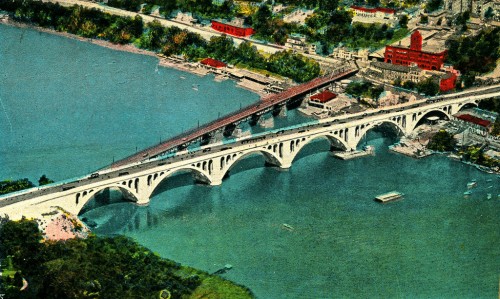
Today –
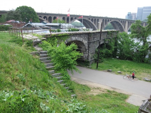
One of those things everyone should go check out sometime.
March 8, 2012 at 4:25 pm #937286consularrider
Participant@DaveK 15983 wrote:
It’s too bad they demolished the aqueduct…
Back in the day looking west –
Today –
One of those things everyone should go check out sometime.
But no direct connection from the CCT? Maybe a long ramp where those stairs are?
") March 8, 2012 at 4:52 pm #937288
March 8, 2012 at 4:52 pm #937288MCL1981
Participant@dasgeh 15969 wrote:
So I’ll throw another question to the group — what do you think the best way to get from the CCT/K Street “Downunder” to the Key Bridge. My commute is going to change this summer, and I’ll likely end up needing to make that trip…
Super easy. Don’t bother going to Wisconsin. You can go right up the path across from the end of the waterfront trail where the trucks always park. There is a ped bridge over the canal and a walkway right up the Key Bridge.
http://maps.google.com/?ll=38.904209,-77.068268&spn=0.001998,0.004128&t=k&z=19
March 21, 2012 at 8:45 pm #938159Rocaka
ParticipantThanks again for all the advice, all! I made the run twice last weekend to make sure I knew my route, and I think I’m really going to enjoy this (I say this now, of course, in August I might be saying something different).
With any luck, I might actually be able to make it all the way to Mason in a few months!
-
AuthorPosts
- You must be logged in to reply to this topic.