August 2016 Road and Trail Conditions
Our Community › Forums › Road and Trail Conditions › August 2016 Road and Trail Conditions
- This topic has 67 replies, 27 voices, and was last updated 8 years, 7 months ago by
 chris_s.
-
AuthorPosts
-
August 4, 2016 at 2:45 pm #1055965
ginacico
ParticipantSweet!
[ATTACH=CONFIG]12230[/ATTACH]
As of this morning, there was still some equipment on the east end, but I would expect it to be gone soon.
August 4, 2016 at 3:32 pm #1055966consularrider
ParticipantEven better is that from your photo it looks like they finally cut back the encroaching vegetation on the north side of the street!
August 4, 2016 at 3:57 pm #1055967 Steve OParticipant
@ginacico 143865 wrote:
N Four Mile Run Drive is being repaved. This is the section of road parallel to the W&OD trail just east of Ohio St / McKinley Rd, which you ride on if you take that exit into Dominion Hills.
[ATTACH=CONFIG]12229[/ATTACH]
Pete’s Tuesday morning hill riders who have noted how ratty it is can rejoice that it’s being resurfaced.
As of today, old pavement has been ground down to rough corduroy, half dozen trucks are milling around, and they’re just starting to lay down new asphalt. Give it another day or so, it’ll be a smoooooooth ride!
I think the county missed a good opportunity to reduce impermeable surface. Given how little this road is used, it could have easily been reduced in width and 1/4 acre of land returned to permeable surface. Right by the stream, too.
August 4, 2016 at 4:30 pm #1055970ParticipantSince my house is on Montana St, I must respectfully disagree. With any amount of snowfall/ice, both Montana and Manchester are too steep for normal cars and we had to rely on 4MR and going out Madison. The narrow road width was very dangerous given the number of walkers and runners in the street there. It’s still very narrow and almost impossible for cars to pass in opposite directions when anyone was parked curbside. Just because you lived on the uphill side … or did you forget your emoticon?
August 4, 2016 at 7:09 pm #1055972Steve OParticipant@consularrider 143880 wrote:
Since my house is on Montana St, I must respectfully disagree. With any amount of snowfall/ice, both Montana and Manchester are too steep for normal cars and we had to rely on 4MR and going out Madison. The narrow road width was very dangerous given the number of walkers and runners in the street there. It’s still very narrow and almost impossible for cars to pass in opposite directions when anyone was parked curbside. Just because you lived on the uphill side … or did you forget your emoticon?
The width of the street after a snowstorm is the width of the plow, not the actual street. They don’t plow it curb to curb. If they narrowed the impermeable surface, the width after a snowstorm would still be the same–the width of the plow.
The cul-de-sac at the west end is 3x as big as necessary, though. Good for unicycle practice I suppose.I would disagree with the “very dangerous” part, too. In conditions that make it impossible to go up the street, I would assume drivers would be traveling dead slow, and both people in cars and on foot would be behaving accordingly. In all the time I’ve lived there I’ve certainly seen people get stuck, but I’ve never seen any “danger” caused by the narrow street after snowstorms.
Lastly, on the four occasions per year that cars might want to pass and someone is parked curbside, one of them could wait 4 seconds to allow the other through first. This sort of things happens on other narrow streets all over the county (I used to live on one that was too narrow to pass when cars were parked, and they always were), and is actually a nice traffic calming device.
August 4, 2016 at 11:27 pm #1055979chris_sParticipantConnector trail from Arlington Blvd Trail >> Washington Blvd Trail is closed. Looks like Gas Line construction maybe? No idea. Haven’t seen any notice from Arlington or VDOT.
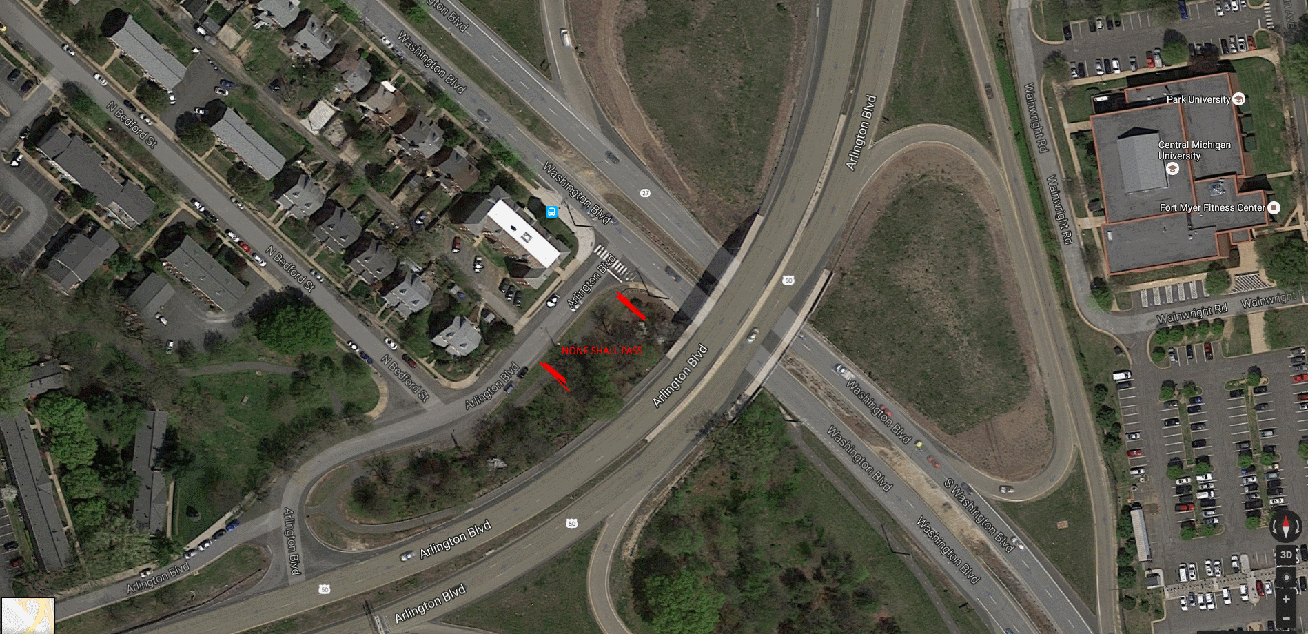 August 5, 2016 at 1:25 pm #1055982
elbows
Participant@chris_s 143889 wrote:
Connector trail from Arlington Blvd Trail >> Washington Blvd Trail is closed. Looks like Gas Line construction maybe? No idea. Haven’t seen any notice from Arlington or VDOT.
I thought I read on the sign that it would be closed through August 12.
August 5, 2016 at 10:47 pm #1055994 bentbike33Participant
Good news! Arlington County has figured out a permanent fix for the Custis Moguls at the Bridge-to-Nowhere!
[ATTACH=CONFIG]12241[/ATTACH]
August 6, 2016 at 12:24 am #1055997DrP
Participant@bentbike33 143907 wrote:
Good news! Arlington County has figured out a permanent fix for the Custis Moguls at the Bridge-to-Nowhere!
According to Webster “Bump” is singular. Did they add a sign before each mogul?
August 6, 2016 at 2:27 am #1055999bentbike33Participant@DrP 143910 wrote:
According to Webster “Bump” is singular. Did they add a sign before each mogul?
No, but there is an identical sign on the other side of the hill for eastbound riders.
August 7, 2016 at 8:20 pm #1057356Overtone
ParticipantAnacostia Riverwalk trail to Bladensburg
Went up the trail today. The builder is making good progress but the conditions N of Benning are worse than when I rode it at the end of June (trip report). Many places that were clean fresh pavement in June now have washes of fine gravel or dirt over them, from construction work beside the trail. The crews have clearly been getting interfered with by people trying to use the trail, so it has sprouted fences across the trail and “construction zone – no trespassing” signs in a couple places. Plenty of people were using the trail on a Sunday morning by going around the fences and ignoring the signs. The one gap in the trail remaining is just N of Benning, but cranes are on site and the framework of the bridge over the marsh has been laid.
Recommend avoiding during work hours until the official opening this fall, and only attempting on weekends if you can tolerate poor surface conditions. My wife and I had a lot of fun – it was a beautiful morning – so certainly worth checking out.
August 8, 2016 at 12:18 pm #1058745bobco85
ParticipantI posted this back on July 1:
@bobco85 142441 wrote:Arlington, VA: The repaving on Walter Reed Dr between King St/Route 7 and Arlington Mill Dr is now complete. It is nice and smooth but lacks any markings other than small dashed lane separators. This stretch has only sharrows except for the intersection of Walter Reed Dr/Arlington Mill Dr which has bike lanes.
It’s been over a month since they finished the paving, yet still there are no markings other than the small dashed line separators and crosswalk outlines. Does anyone know when the final markings (lane separators and bike sharrows) will be painted?
August 8, 2016 at 12:33 pm #1058747 SunyataParticipant
@bobco85 144215 wrote:
I posted this back on July 1:
It’s been over a month since they finished the paving, yet still there are no markings other than the small dashed line separators and crosswalk outlines. Does anyone know when the final markings (lane separators and bike sharrows) will be painted?
They will be painting the lines on Four Mile Run Drive between today and tomorrow, so my guess is they will do that section of Walter Reed at/about the same time.
August 8, 2016 at 1:00 pm #1058749chris_sParticipant@bobco85 144215 wrote:
I posted this back on July 1:
It’s been over a month since they finished the paving, yet still there are no markings other than the small dashed line separators and crosswalk outlines. Does anyone know when the final markings (lane separators and bike sharrows) will be painted?
We’ve been waiting for the southbound bike lane on South Courthouse Road to be striped for over 10 months, so simmer down buddy.
August 8, 2016 at 1:24 pm #1058670 -
AuthorPosts
")
- You must be logged in to reply to this topic.