Desire path between Humpback bridge and Mason bridge
Our Community › Forums › Road and Trail Conditions › Desire path between Humpback bridge and Mason bridge
- This topic has 24 replies, 11 voices, and was last updated 10 years, 1 month ago by
Rod Smith.
-
CreatorTopic
-
May 12, 2014 at 1:08 pm #915295
 lordofthemarkParticipant
I’ve come to rely on it to make my commute easier. Has there been any discussion with NPS about paving it? Wouln’t cost to much. Are there safety and liability issues with doing that?
-
CreatorTopic
-
AuthorReplies
-
May 12, 2014 at 2:52 pm #1000907
KLizotte
ParticipantIt isn’t an NPS issue, the hold up is the Pentagon stopping it for “security reasons” since it is their property. I see quite a few cyclists heading that way in the morning. What kind of condition is the path in? I always take the Columbia Island route but a shorter route may come in handy during bad weather.
May 12, 2014 at 3:06 pm #1000910lordofthemarkParticipant@KLizotte 84982 wrote:
It isn’t an NPS issue, the hold up is the Pentagon stopping it for “security reasons” since it is their property. I see quite a few cyclists heading that way in the morning. What kind of condition is the path in? I always take the Columbia Island route but a shorter route may come in handy during bad weather.
I’m not talking about that awful path through the weeds to the Pentagon. I’m talking about that maybe 10 foot long dirt rut in the grass between the bottom of the Humpback and the beginning of the rise up to the Mason. It’s not much shorter, than going to the proper trail intersection, but it makes a lot of difference in terms of momentum. The only problem with it not being paved is that, even on a hybrid, the bump down to the dirt and back up is uncomfortable.
edit – I guess when I said between I was not clear. Its not merely located between, its what I ride after I’ve gone Columbia Island to Humpback, and then am heading up to the 14th Street bridge (and also in the reverse direction.)
May 12, 2014 at 3:18 pm #1000913ParticipantOh duh. Didn’t read your original post closely enough. dbb, I believe, mentioned some time ago that it used to be paved but NPS “unpaved” it in hopes grass would grow there. I think there is a general reluctance to pave any more along the Potomac due to environmental reasons which I can understand. I do not expect to see that shortcut paved any time soon.
May 12, 2014 at 3:46 pm #1000922cyclingfool
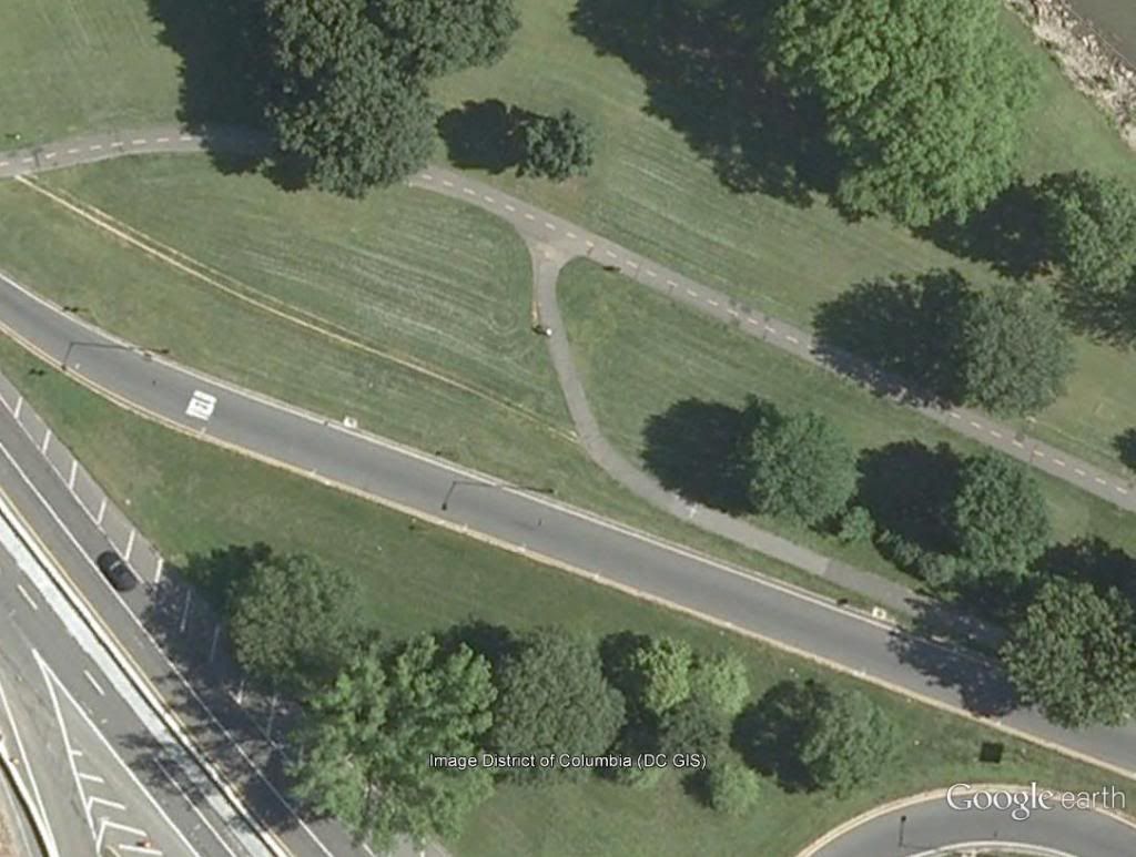
ParticipantWhile concerns about impermeable surfaces along the river have their place, the amount of new asphalt involved would be trivial. We’re talking about 12 feet wide by 100 feet long max. Given the asphalt jungle at this spot (see screen capture below), I can’t see how this small addition would be an issue. Just a few hundred feet away, by comparison, the GWP as it passes under the CSX tracks is 100 ft of uninterrupted pavement from fog line to fog line (according to measure tool in Google maps). Just to give some perspective.
[ATTACH=CONFIG]5576[/ATTACH]
If the NPS is so concerned about runoff into the river, maybe they could also do something about the places where the runoff from the 14th St bridges is channeled to and literally dumped straight down onto heads of cyclists riding along the MVT… like adding additional pipe and diverting the storm water runoff from the bridges into a small swale west of the trail, for instance.
IOW, if this is really NPS’ position, they’re either disingenuous or handcuffed by environmental/runoff regulations that can’t see the forest for the trees, or both.
All of that is to say, I think the NPS should at least look into (re)formalizing the desire path here. While they’re at it, paving the desire path at the Crystal City Connector intersection with the MVT would also be nice.
But none of this is likely to happen, which is just one more reason I happily roll with 2″ tires on my touring/commuter bike. Bump? There was a bump there?
") May 12, 2014 at 4:29 pm #1000928
May 12, 2014 at 4:29 pm #1000928dasgeh
ParticipantI happened to have been right there, talking to dbb just last week, as we finished a conversation before riding off in different directions.
Honestly, it don’t think it’s a safe option for people coming downhill off the bridge. While we were there (~5 min), we saw people do all sorts of dumb stuff at the intersection, but the dumbest were the people bombing down the hill from the bridge, taking the desire line full speed, and continuing on to the main MVT with no regard for who is already on it.
Of course, I’ve also seen people do similar, staying on the asphalt and turning right SUPER wide. In fact, I had one almost ride into me one lovely day last year when I was biking that way with the kids. So it’s not a perfect solution. Maybe they could put up a sign telling people it’s a crowded area and they need to STFD!
May 12, 2014 at 4:34 pm #1000929ParticipantI happened to have been right there, talking to dbb just last week, as we finished a conversation before riding off in different directions.
Honestly, it don’t think it’s a safe option for people coming downhill off the bridge. While we were there (~5 min), we saw people do all sorts of dumb stuff at the intersection, but the dumbest were the people bombing down the hill from the bridge, taking the desire line full speed, and continuing on to the main MVT with no regard for who is already on it.
Of course, I’ve also seen people do similar, staying on the asphalt and turning right SUPER wide. In fact, I had one almost ride into me one lovely day last year when I was biking that way with the kids. So it’s not a perfect solution. Maybe they could put up a sign telling people it’s a crowded area and they need to STFD!
May 12, 2014 at 4:47 pm #1000930jhr
Participant@dasgeh 85006 wrote:
Honestly, it don’t think it’s a safe option for people coming downhill off the bridge. While we were there (~5 min), we saw people do all sorts of dumb stuff at the intersection, but the dumbest were the people bombing down the hill from the bridge, taking the desire line full speed, and continuing on to the main MVT with no regard for who is already on it.
I think the solution would be to mark it as one-way only (in the direction toward the 14th st bridge).
May 12, 2014 at 4:51 pm #1000932dbb
ParticipantThere appears to only have been a desire path there. Prior to the Humpback reconstruction the trails weren’t as close together and the desire path was much longer and may have been used less. Other than the appearance issues, my objections to the desire path is that folks bombing down the slopes from the Humpback or 14th Street Bridges end up with a fair amount of speed and that may result in conflicts with other trail users.
From an engineering perspective, we are riding one of the most efficient forms of transport (in terms of cal/kg/km) so taking shortcuts that damage the surrounding terrain seems, well, wrong. Were I king, I would plant sticker bushes or install stones. The cutoff to the Crystal City Connector got moved about 6-7 years ago, from where the desire line is to the current location.
May 12, 2014 at 5:05 pm #1000934Participant@dbb 85009 wrote:
Were I king, I would plant sticker bushes or install stones.
How about planting berries, so we can enjoy a trail side snack every now and then?
") May 12, 2014 at 5:13 pm #1000937lordofthemarkParticipant
May 12, 2014 at 5:13 pm #1000937lordofthemarkParticipant@dasgeh 85006 wrote:
I happened to have been right there, talking to dbb just last week, as we finished a conversation before riding off in different directions.
Honestly, it don’t think it’s a safe option for people coming downhill off the bridge. While we were there (~5 min), we saw people do all sorts of dumb stuff at the intersection, but the dumbest were the people bombing down the hill from the bridge, taking the desire line full speed, and continuing on to the main MVT with no regard for who is already on it.
Of course, I’ve also seen people do similar, staying on the asphalt and turning right SUPER wide. In fact, I had one almost ride into me one lovely day last year when I was biking that way with the kids. So it’s not a perfect solution. Maybe they could put up a sign telling people it’s a crowded area and they need to STFD!
Okay, well I can guarantee I apply my brakes coming down from Mason, but that still leaves me momentum that helps (I also glance for through traffic on the MVT.) I guess I have reached the point I could manage without the help going up the humpback, but the momemntum in the other direction, up to the Mason bridge, really helps – note while I am getting better and my weight is down, I’m still not that strong and do suffer from aerophagia on upgrades, and my bike is a decent but not that light hybrid, not a light road bike. I know, rule number 5, I’m trying.
Also I only take the desire path because it’s already so well established. I avoid some others (like the ones around the Jefferson.)
May 12, 2014 at 6:09 pm #1000946 Steve OParticipant
Pave it. Or expand the current intersection to make it easier to turn in all directions.
The argument that the current intersection is somehow safer does not hold water IMO. There are already people bombing down, so whether it is paved or not makes no dif. Blocking it with something–unless it’s a stone wall–will likely get defeated, and then there will be some sort of pathway through the bushes. Instead of trying to force people (peds, too) to follow the pathway that has been arbitrarily placed in the first place, give them the pathway they have clearly indicated they want. With good sightlines (which we have), I don’t anticipate it being a problem.
May 12, 2014 at 8:16 pm #1000965Participant@jhr 85007 wrote:
I think the solution would be to mark it as one-way only (in the direction toward the 14th st bridge).
That crossed my mind, too, which would actually mean that a paved path could be narrower, say 5-6 ft, so NPS concerns about runoff could allayed even further. It would be something akin to traffic engineers’ beloved right turn slip lane.
May 12, 2014 at 9:28 pm #1000971Steve OParticipant@jhr 85007 wrote:
I think the solution would be to mark it as one-way only (in the direction toward the 14th st bridge).
That’ll work.
(hahahahahahaha)
May 13, 2014 at 1:38 am #1000985Steve OParticipant@dbb 85009 wrote:
From an engineering perspective, we are riding one of the most efficient forms of transport (in terms of cal/kg/km) so taking shortcuts that damage the surrounding terrain seems, well, wrong. Were I king, I would plant sticker bushes or install stones. . I might agree with this only if there were some logical reason for the existing location of the path. However, my guess is that the path is where it is because someone happened to draw it on a piece of paper once upon a time. So now cyclists are supposed to follow the paved path just because some anonymous person, who may not have even had sufficient coffee that day, drew a line on a sheet of paper? Sorry. (I don’t recall the BAC being consulted on the design of this intersection. Were any cyclists at all?) If the cyclists and pedestrians have voted with their feet and wheels that there is a better design, then why would we ignore their expressed opinion and favor the arbitrary current design?
How about a quick thought experiment? Imagine that the desire path had been paved from the beginning and now NPS were proposing to remove it to create a little more permeable surface. Would you favor and support that?
May 13, 2014 at 2:20 am #1000987ParticipantI suppose my fingerprints are sort of on the existing ramp down from the 14th Street Bridge. As the Federal Highway Administration was doing the work in conjunction with the Humpback Bridge construction, I offered a running critique of the trail modifications. I think I helped to get the tight corner at the stop sign softened a bit. Unfortunately it was after the fact and they eased the corners well after they paved the trail. It would have been better if they had paved it all at once.
I don’t think there was any formal coordination between the NPS and the BAC and that is something I’m trying to work on. I think we can provide input to the NPS in a manner that works and doesn’t get the NPS into trouble with the Federal Advisory Committee Act. Cyclist engagement during the construction would have reduced the number of fixes that would have been needed.
I doubt that it was designed any more than any other part of the cycling infrastructure we use every day – I’m thinking of the blind turn on the Custis under I66, the s turn of doom, and myriad others. These are trails that I ride frequently and I’ve learned where to slow down. I doubt a formal design of the stretch of trail between the Humpback and the 14th Street Bridge would have resulted in anything significantly different. What would we have done, move the intersection 30 feet upstream or down? A couple of years ago, I worked wtih the NPS on the redesign of the trail between Memorial Circle and the GWMP crosswalk and we walked it and discussed the alignment. At some level, it was four or five folks and a can of spray paint.
I think trail intersections are almost always a challenge because we disrupt the half of the riders going your direction and half the riders going the opposite direction. This begs caution and it seems to me that riders freeforming the route increases the risk of collision. Probably more of an irritant than full fledged safety issue but it still bothers me.
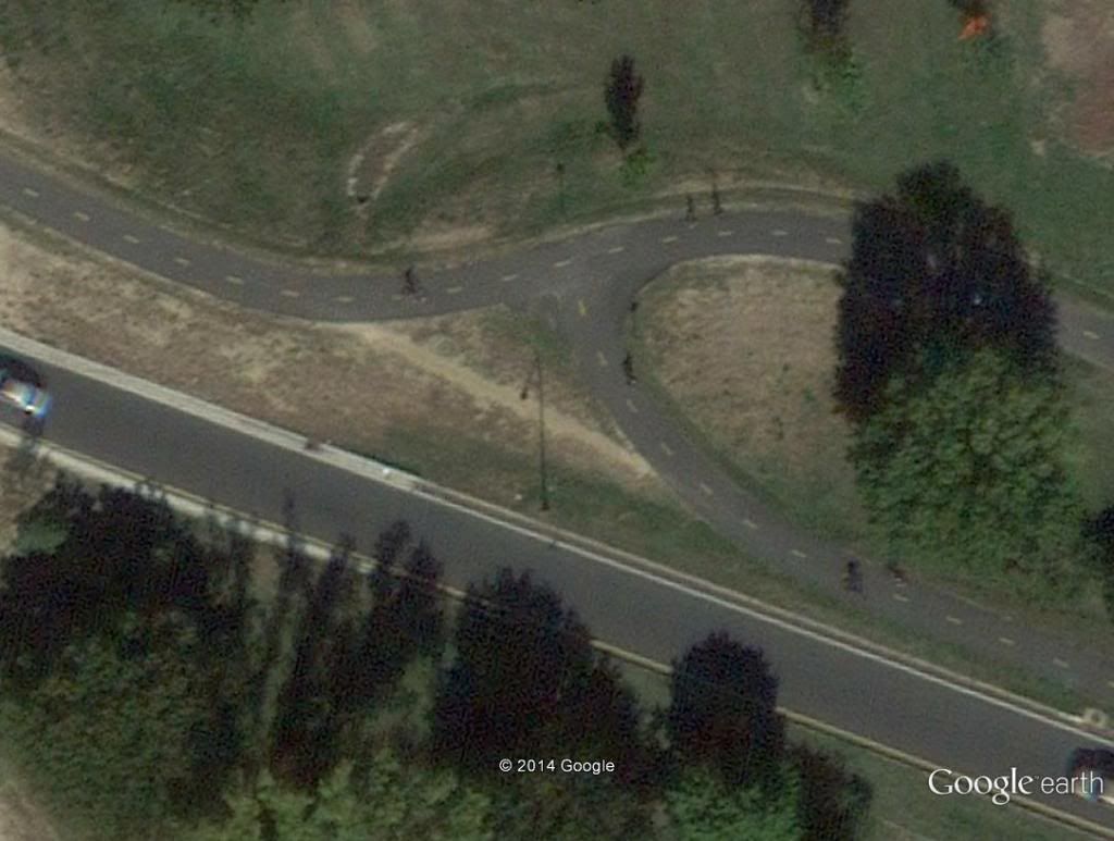
Here is what the trail looked like in 2007
and this is what it looks like now
I was a facilities engineer in the Army and tried to keep people from creating desire lines on the base with posts and chains (too much painting) and sticker bushes (which took no painting). It just kind of annoys me that we complain the NPS isn’t spending enough to maintain the trails (which I consider to be a real treasure) and then we take actions (through the use of desire lines) that tend to increase the trail maintenance cost (or decrease the beauty of the trails).
-
AuthorReplies


- You must be logged in to reply to this topic.