Issue on 4 Mille Run trail just before Mount Vernon
Our Community › Forums › Road and Trail Conditions › Issue on 4 Mille Run trail just before Mount Vernon
- This topic has 135 replies, 27 voices, and was last updated 11 years, 5 months ago by
PotomacCyclist.
-
AuthorPosts
-
July 9, 2013 at 4:24 pm #974921
bobco85
ParticipantThere are plans to build that desire path into an actual trail, but they’re not going to be doing it anytime soon. I know it’s been mentioned on this forum before, but I will update my post when I find the thread about the plans.
(EDIT) Okay, found it! Here’s the thread with more details: http://bikearlingtonforum.com/showthread.php?2052-4MR-trail-access-to-Potomac-Ave-and-such-plans-in-the-works
July 9, 2013 at 6:59 pm #974939chris_s
ParticipantSome updates to that thread that bobco linked:
When the railroad viaduct comes down this year, the contractor will be installing a temporary connection. The temporary connection will, I understand, definitely involve a ridiculous and convoluted set of ADA-compliant ramps and may also include a bicycle staircase. *crosses fingers*
The actual, permanent, for reals trail connection is beginning design and won’t be built until probably 2016.
July 11, 2013 at 3:03 pm #975152elvis313
ParticipantHello Jasen,
The situation at this location is actually about to get improved. Probably before the end of the year. As part of a redevelopment project on the south side of the run, one of the bridges over Four Mile Run is being demolished, which will likely put this section of the Four Mile Run trail out of service for part of that time. Their approved detour involves construction of a temporary ADA compliant switchback ramp, along with a set of stairs at the location of the current eroding footpath. The stairs will also include a rail installed along the steps to facilitate rolling bikes up and down that slope. As Kevin mentioned, these improvements will be located within the City of Alexandria, which is responsible for permitting and oversight of the project.David J Goodman – RA, AICP
Bicycle & Pedestrian Programs Manager
2100 Clarendon Boulevard, suite 900
Arlington, VA 22201
703.228.3709From: Kevin Stalica On Behalf Of Trails
Sent: Thursday, July 11, 2013 10:33 AM
To: Farmer, Jasen (US – Arlington)
Cc: Raynard Clemons; Jason Papacosma; David Goodman; David Patton (dpatton@i-c.net); Lisa.jaatinen@alexandriava.gov
Subject: RE: Trail issue, erosionJasen,
Thank you for writing about the hill near the Four Mile Run Trail perpendicular to Potomac Avenue. This area has been problematic for a long time as you have observed. Increased density in the area has exacerbated the issue with increased foot traffic over the last few years. You may be surprised to learn that this site is not Arlington County property. It is officially in the City of Alexandria. Although Arlington maintains the trail through this section, any alterations to the area would be primarily a function of Alexandria or possibly a coordination between the two jurisdictions. New construction of steps or ramps requires that they be ADA accessible. The topography at this location is so extreme that ADA access may not be practical. Funding would also need to be found. The most expeditious solution may be blocking existing footpaths to let vegetation grow back and stop erosion. There are existing connections but not in the same spot. If a new connection is made, a different entry point is recommended. I have copied my colleagues on this message in case they have other information to share.
I hope we will eventually find a solution to this problem. Meanwhile, my crew will continue to clean the trail of any debris.
Kevin Stalica
Park Service Area Manager / Trails Manager / CPSI
Arlington County Parks and Natural ResourcesA 2700 S Taylor St, Arlington, VA 22206
T 703-228-7743
F 703-228-6507
E kstalica@arlingtonva.us
W http://www.arlingtonva.us
W http://www.bikearlington.comJuly 16, 2013 at 5:35 pm #975528chris_s
ParticipantSpeaking of bridge/viaduct demolition…
“The Four Mile Run Joint Task Force cordially invites you to a ceremonial start of bridge demolition at Four Mile Run as part of the Four Mile Run Restoration Plan on Monday, July 22, 2013 at 10:00 a.m. The event will be held on the north side of the westernmost bridge between Route One and Potomac Avenue. Please park along Potomac Avenue and walk to the event site. This event will be held rain or shine.”
http://www.novaregion.org/index.aspx?NID=216
Progress!
July 22, 2013 at 9:53 pm #976125dbb
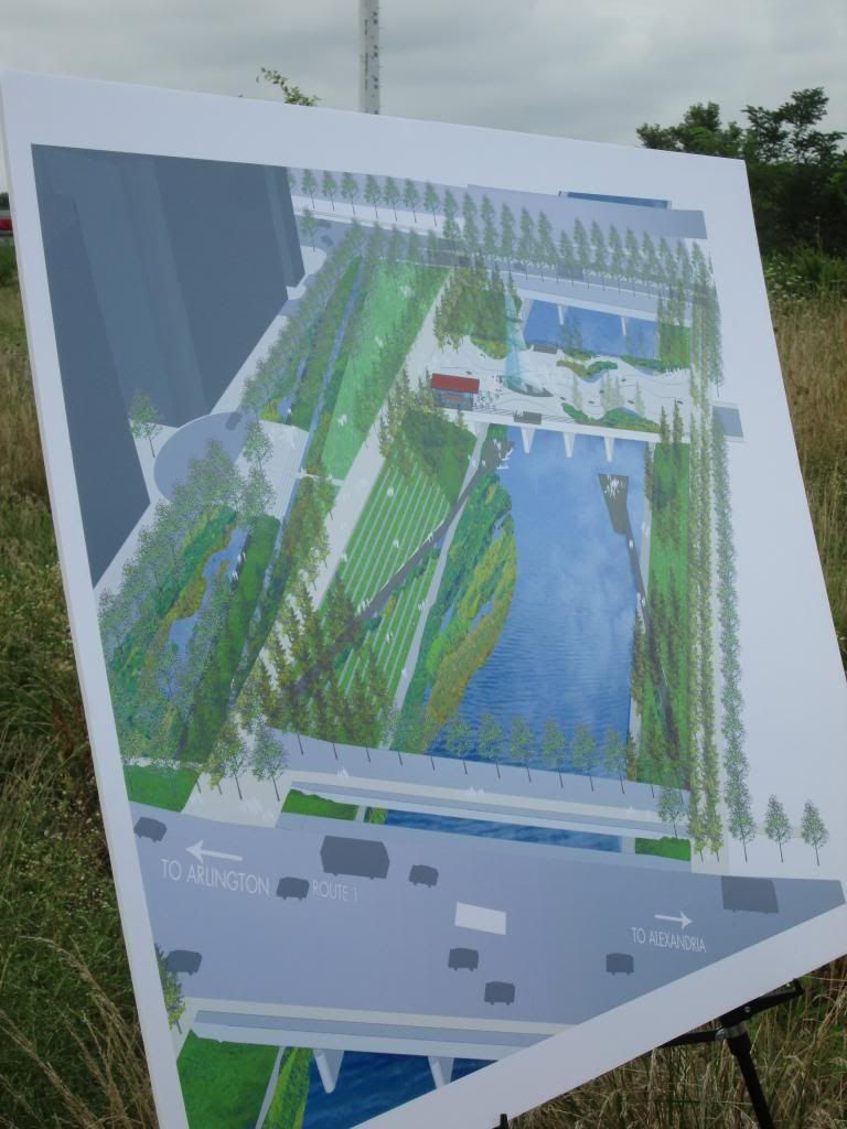
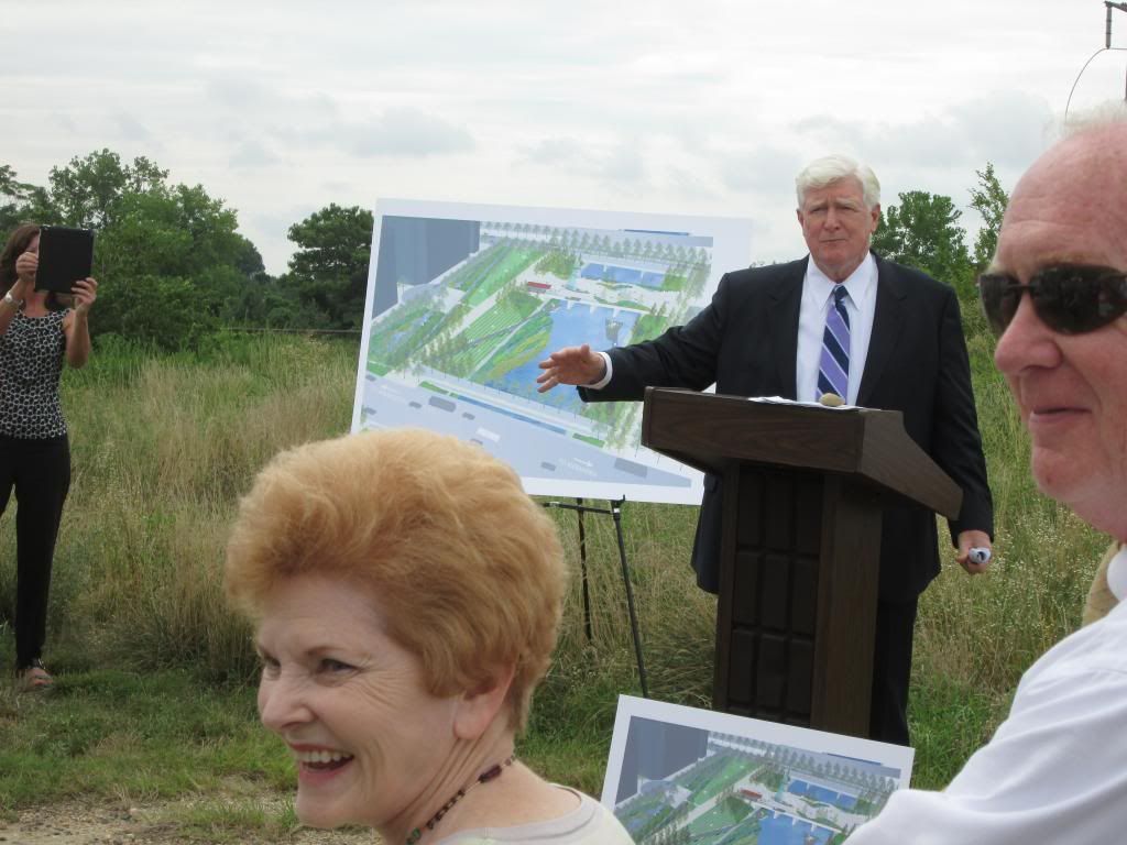
ParticipantArlington and Alexandria had a joint ceremonial beginning of the bridge demolition for one of the abandoned railroad bridges across Four Mile Run. The plan is to take the big RR bridge out that is closest to US Route 1. The schedule was not announced today but it will be happening soon.
This rendering is looking east towards the river.
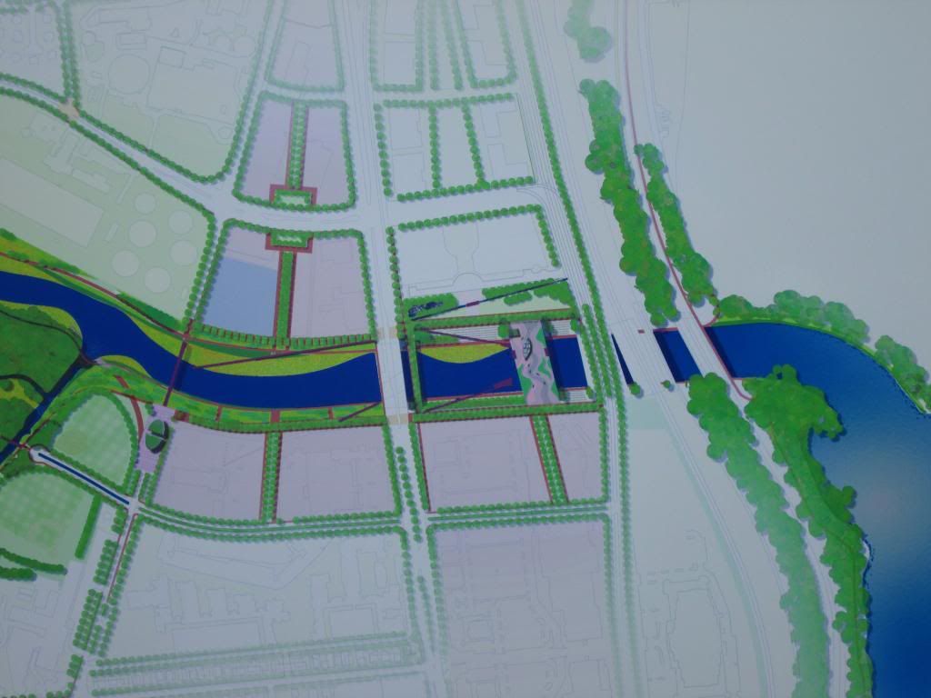
This shows the US Route 1 bridge on the left and the Potomac on the right. The bridges (from left to right) are US Route 1, a ped bridge that will remain, a RR bridge that will become a over the water park, Potomac Ave (with the trees), the remaining operational RR and WMATA bridge “blended” together (I’d suggest that is an artifact of the rendering and not a plan) and the GWMP bridge.
The rendering shows a bike path from the upper level down to the trail on the east side of Route 1, a feature that will make travel to/from the Crystal City area much easier.
Congressman Moran helped with attention and funding. The Mayor of Alexandria and Jay Fisette also attended. All indicated the biking facilities along FMR were a key aspect of the project.
Additional details at: http://www.arlnow.com/2013/07/22/demolition-begins-on-four-mile-run-bridge/#more-80774
August 4, 2013 at 4:29 pm #977472CaseyKane50
ParticipantOn Friday a contractor was installing a fence along the 4MRT perhaps in preparation for the planned demolition of the bridge and the construction of the new path connecting Potomac Avenue to the 4MRT. The fence blocks the desire path, but has not stopped users of the path. This morning, I saw a woman climbing over the fence to get on to the 4MRT.
[ATTACH=CONFIG]3409[/ATTACH][ATTACH=CONFIG]3410[/ATTACH]
August 6, 2013 at 7:26 pm #977589consularrider
Participant@CaseyKane50 59977 wrote:
…The fence blocks the desire path, but has not stopped users of the path. This morning, I saw a woman climbing over the fence to get on to the 4MRT…
Yeah, the fence was bent even more flat there as of yesterday evening. This morning the crew had straightened it back up and strung red tape between taller fence posts. There was also a backhoe starting to do something along the side of the bridge.
August 9, 2013 at 3:21 pm #977816CaseyKane50
ParticipantThis morning the contractor was finishing up installing a taller fence. I stopped to take a couple of pictures and got a chance to speak to one of the crew. Work will start either later today or Monday to install the bike path and staircase He thought that the work would take 4 weeks to complete. The bike path will zigzag up the hill and the staircase will come down along the Potomac Avenue bridge.
[ATTACH=CONFIG]3434[/ATTACH]
[ATTACH=CONFIG]3435[/ATTACH]
August 9, 2013 at 3:24 pm #977817consularrider
ParticipantSo is the path going to be like the S Curve of Doom on the Custis at the Lyon Village Shopping Center?
August 9, 2013 at 3:37 pm #977819CaseyKane50
ParticipantHe described it as a z pattern. It might be similar to the Clermont Connector, but without as many switchbacks.
[ATTACH=CONFIG]3436[/ATTACH]
August 9, 2013 at 4:13 pm #977821bobco85
Participant@CaseyKane50 60449 wrote:
He described it as a z pattern. It might be similar to the Clermont Connector, but without as many switchbacks.
[ATTACH=CONFIG]3436[/ATTACH]
I call it either the Eisenhower Connector or “our Lombard Street.” Still, I think it will be a lot nicer than what was there before.
August 9, 2013 at 5:06 pm #977824consularrider
ParticipantLooks like more for runners than cyclists.
August 10, 2013 at 3:19 pm #977869CaseyKane50
ParticipantLooking down from Potomac Avenue to the construction site
[ATTACH=CONFIG]3443[/ATTACH]
[ATTACH=CONFIG]3444[/ATTACH]
August 10, 2013 at 6:35 pm #977872JimK
ParticipantTwo questions: How long do you think the 4MRT will be closed when the bridge is demolished? What is the best detour from the 4MRT to the MVT?
August 10, 2013 at 8:52 pm #977875DismalScientist
Participant@JimK 60507 wrote:
What is the best detour from the 4MRT to the MVT?
From 4MRT to northbound MVT (and vice versa): Eads Street North at the Sewage plant to some street crossing US 1 (either 23rd or 18th). East (right) on that street to Crystal drive and then left (north) on Crystal Drive to the Water Park. Right on the connector trail to MVT.
-
AuthorPosts
- You must be logged in to reply to this topic.